Overview
The Qatar oil concession, granted to the Anglo-Persian Oil Company by the Ruler of Qatar, Shaikh Abdullah bin Jasim Al Thani in 1935, ushered in a new era for relations between London and Doha. The negotiations had been helped in no small part by the British offer of military protection, in exchange for exclusive rights to bid for the concession. In fact, as early as spring 1934, the British Government had begun investigating how it would provide such protection. An aerial reconnaissance of the Qatar Peninsula, to be undertaken by the RAF, was scheduled for 9 May 1934, mainly to identify suitable landing grounds, but also to impress Shaikh Abdullah.
Archive items in this article


The Aerial Reconnaissance
In the preparations for the aerial reconnaissance, it was noted that oblique photographs would be required of all landing-ground sites and water wells, which included a potential site west of Doha and wells in the vicinity of Doha Town.
The reconnaissance went ahead as planned, commencing at 2:05am GMT on 9 May 1934. Four Wapiti aircraft from the RAF’s No. 84 Squadron departed from Muharraq, Bahrain, along with two flying boats from the No. 203 Squadron. The reconnaissance lasted a total of four hours and twenty minutes.


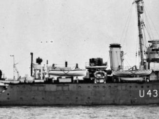
In command was Group Captain Richard Ernest Saul, working in close cooperation with the Political Agent A mid-ranking political representative (equivalent to a Consul) from the diplomatic corps of the Government of India or one of its subordinate provincial governments, in charge of a Political Agency. at Bahrain, Lieutenant-Colonel Percy Gordon Loch, who was also on board one of the flying boats. Once the mission was complete the flying boats landed at Doha, where they were met by HMS Shoreham and HMS Bideford. On the morning of 10 May, Group Captain Saul accompanied Loch and the commanding officer of HMS Bideford on a visit to Shaikh Abdullah.

The Findings: Large Mounds and Landing Grounds
The RAF Command in Iraq produced a report of the reconnaissance later that month, and initially sent it to the Air Ministry, which forwarded copies to the India Office The department of the British Government to which the Government of India reported between 1858 and 1947. The successor to the Court of Directors. , Foreign Office, War Office, and Admiralty, as well as to the Committee of Imperial Defence.
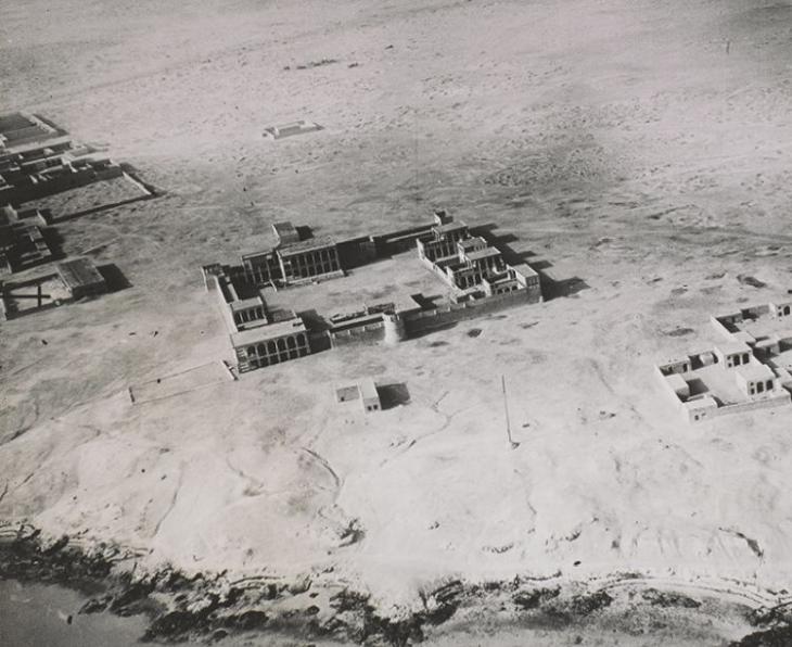
The report states that a ‘fairly satisfactory site’ for a landing ground existed near the Shaikh’s palace at Fort Raiyan [Al Wajbah Fort in Al Rayyan], about seven miles west of Doha. It also notes potential sites near Karasna [al-Kir’ānah] and Salwa, but advises that reconnaissance on the ground will be needed to confirm whether or not they are suitable (IOR/L/PS/12/1956, f. 25r). In addition, although the ground in the immediate vicinity of Doha had been searched, ‘no area fit for landing on was noted’ (f. 28r). The report remarks that elsewhere ‘soft sand had formed mounds large enough to prevent a safe landing over almost the entire stretch of country’ (f. 27r).
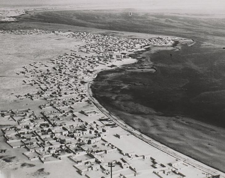
A Very Different Doha
The India Office’s copy of the report includes fifteen photographs taken during the reconnaissance, as well as a tracing of the whole Qatar Peninsula which suggests amendments to an earlier chart of the coastline. These photographs are some of the earliest images of Qatar from the air. Among the notable landmarks captured are Fort Raiyan and Doha Palace, with the latter appearing in remarkably sharp detail.
Most intriguing though are two photographs of Doha Town, which seems to bear little resemblance to today’s ultra-modern metropolis.
Related Articles


A Turning Point
There would be further aerial surveys of Qatar. Another reconnaissance was carried out in October 1935, albeit for rather different reasons. However, it is the small collection of photographs from May 1934, taken just over a year before the granting of the oil concession, that contains the most striking images. These pictures offer a rare glimpse of a country approaching a defining moment in its history, one that would eventually transform both its fortunes and its landscape beyond recognition.
