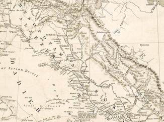
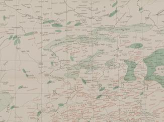
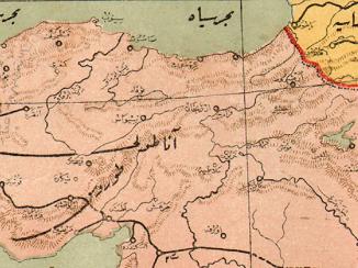
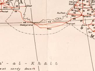
'Map 1. Map to illustrate the Agreements of 1916 in regard to Asia Minor, Mesopotamia, &c.'
Mss Eur F112/570, f 26

2 items in this record
Search within this record
The record is made up of 1 map sheet. It was created in 1918. It was written in English. The original is part of the British Library: India Office The department of the British Government to which the Government of India reported between 1858 and 1947. The successor to the Court of Directors. Records and Private Papers Documents collected in a private capacity. .
About this record
- Content
Classified 'Secret'.
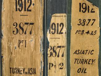
Map forms a part of Mss Eur F112/570, ff 24-30.
The original map bears the secondary title 'A Map of Turkey in Asia'. A small paper sheet has been pasted over this and bears a later secondary title 'Map 1. Areas referred to in the Agreements between Great Britain, France, Russia, and Italy.'
Map bears the printed designation 'Map 1'. Depicts a proposed division of the Ottoman Empire into spheres of influence and protection by the Allied powers. The division is based on agreements reached between 1916 and 1918. Portrays hydrology, relief by spot heights A point on a map at which the height of the land is recorded. and hachures Lines drawn on a map to indicate the direction and steepness of slope. , roads and tracks, railways, submarine telegraph lines, settlements, place names and international boundaries. Various blocks of overprinted colour shading correspond to French, British, Italian, Russian and International spheres of influence, including provision for an independent Arab state within the French and British spheres.
The base map A map portraying background detail. bears the imprint 'London: Edward Stanford, 12, 13 & 14, Long Acre, W.C.' The printer's imprint 'Harrison & Sons, Lith. St. Martins Lane, W.C.' and print code '(155.11/18.6423) F[oreign].O[ffice].238.' have been added later.
Another copy of this map is at Mss Eur F112/570, f 19.
- Extent and format
- 1 map sheet
- Area map covers
- Map loading...
- Scale
- Scale approximately 1:6,969,600
- Scale designator
- Horizontal
- Orientation
- North
- Degree coordinates
- Top-left: 44° 3' 41.4" N, 21° 7' 39.72" E
Top-right: 44° 3' 41.4" N, 53° 57' 26.64" E
Bottom-left: 28° 12' 55.44" N, 21° 7' 39.72" E
Bottom-right: 28° 12' 55.44" N, 53° 57' 26.64" E - It is part of
- 90 imagesRef: Mss Eur F112/570
- Physical characteristics
Materials: Printed in colour on paper
Dimensions: 243 x 388mm, on sheet 287 x 449mm
- Written in
- English in Latin script
- Type
- Map
Archive information for this record
- Original held at
- British Library: India Office The department of the British Government to which the Government of India reported between 1858 and 1947. The successor to the Court of Directors. Records and Private Papers Documents collected in a private capacity.
- Access conditions
Unrestricted
- Archive reference
- Mss Eur F112/570, f 26
- Date(s)
- 1918 (CE, Gregorian)
- Related primary sources
An online version of the document which the volume Mss Eur F/112/570, ff 24-30 accompanies can be found at:
- Political Intelligence Department, Foreign Office, Memorandum respecting the Settlement of Turkey and the Arabian Peninsula (1918) - http://filestore.nationalarchives.gov.uk/pdfs/small/cab-24-72-GT-6506-2.pdf [accessed 11 December 2019]
Access & Reference
History of this record
Related material
Related search terms
- Places
- MesopotamiaAsia Minor
- People & organisations
- Edward Stanford and CoForeign OfficeHarrison and Sons Ltd
Use and share this record
- Share this record
- Cite this record in your research
'Map 1. Map to illustrate the Agreements of 1916 in regard to Asia Minor, Mesopotamia, &c.', British Library: India Office Records and Private Papers, Mss Eur F112/570, f 26, in Qatar Digital Library <https://www.qdl.qa/archive/81055/vdc_100140102009.0x00001a> [accessed 18 July 2026]
- Link to this record
https://www.qdl.qa/en/archive/81055/vdc_100140102009.0x00001a
- IIIF details
This record has a IIIF manifest available as follows. If you have a compatible viewer you can drag the icon to load it.https://www.qdl.qa/en/iiif/81055/vdc_100000001491.0x0002da/manifestOpen in Universal viewerOpen in Mirador viewerMore options for embedding images
Copyright: How to use this content
- Reference
- Mss Eur F112/570, f 26
- Title
- 'Map 1. Map to illustrate the Agreements of 1916 in regard to Asia Minor, Mesopotamia, &c.'
- Pages
- 26r:26v
- Author
- Foreign Office
- Usage terms
- Public Domain
- Reference
- Mss Eur F112/570, f 26
- Title
- 'Map 1. Map to illustrate the Agreements of 1916 in regard to Asia Minor, Mesopotamia, &c.'
- Pages
- 26r:26v
- Author
- Foreign Office, Political Intelligence Department
- Usage terms
- Public Domain
- Reference
- Mss Eur F112/570, f 26
- Title
- 'Map 1. Map to illustrate the Agreements of 1916 in regard to Asia Minor, Mesopotamia, &c.'
- Pages
- 26r:26v
- Author
- Harrison and Sons Ltd
- Usage terms
- Public Domain
- Reference
- Mss Eur F112/570, f 26
- Title
- 'Map 1. Map to illustrate the Agreements of 1916 in regard to Asia Minor, Mesopotamia, &c.'
- Pages
- 26r:26v
- Author
- Edward Stanford & Co, publishers and stationers
- Copyright
- ©Edward Stanford Limited
- Usage terms
- Creative Commons Non-Commercial Licence