Maps and Associated Documents Relating to the Post-war Realignment of Boundaries in the Former Ottoman Empire
Mss Eur F112/570


90 items in this record
Search within this record
The record is made up of 42 map sheets and 8 folios. It was created in Early 1890s-1920?. It was written in English, French and Italian. The original is part of the British Library: India Office The department of the British Government to which the Government of India reported between 1858 and 1947. The successor to the Court of Directors. Records and Private Papers Documents collected in a private capacity. .
About this record
- Content
Maps and documents prepared for the re-alignment of boundaries in the former Ottoman Empire in the aftermath of the First World War. As follows:
- f 1 'Sketch Map of Asia Minor, showing approximate course of Roads and Railways'. With boundary additions. Engraved by Emery Walker Ltd. [1915-17]
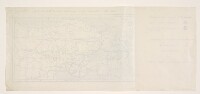
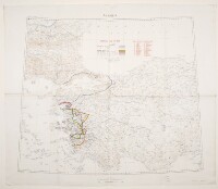
- f 2 Western Turkey, showing the Zone of the High Commissioner and areas ceded to Greece and Italy. [Early 1890s-1920?]
- ff 3-4 'Boundary of Demilitarized Zone about Constantinople [Istanbul]. (Meeting of Allied Naval & Military Advisors, London 16.2.20.)' Created by the Geographical Section, General Staff
- f 5 'Izmir (Smyrna)'. With boundaries and population statistics added in manuscript. 1916-20
- f 6 ' Anatolia Peninsula that forms most of modern-day Turkey. '. Created by the War Office August 1919 with boundaries and population statistics added to 20 February 1920
- f 7 ' Anatolia Peninsula that forms most of modern-day Turkey. '. Created by the War Office August 1919 with boundaries and proposed boundaries added to 30 March 1920
- f 8 'Map No. 1. Turkey in Europa. Zone of the Straits, Smyrna, the [Aegean] Islands'. Created by 'S[ervice].G[éographique de l'].A[rmée]. 28.7.20.'
- f 9 'A Map of Turkey in Asia'. Proposed division of Ottoman Empire after the First World War. [1918?]
- f 10 'Map to illustrate the Agreements of 1916 in regard to Asia Minor, Mesopotamia, &c.' Created by Edward Stanford. [1918?]
- f 11 'Map to illustrate the Agreements of 1916 in regard to Asia Minor, Mesopotamia, &c.' Created by Edward Stanford and the Foreign Office, October 1918
- ff 12-14 'Map to illustrate the Agreements of 1916 in regard to Asia Minor, Mesopotamia, &c.' Created by Edward Stanford and the Foreign Office, January 1919
- ff 15-16 'Map to illustrate the Agreements of 1916.' Turkey in Asia. Created by Edward Stanford, October 1919
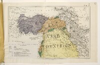
- ff 17-23 'Maps illustrating Memorandum respecting the Settlement of Turkey and the Arabian Peninsula.' [Published by the Political Intelligence Department, Foreign Office, 21 November 1918]
- ff 24-30 'Maps illustrating Memorandum respecting the Settlement of Turkey and the Arabian Peninsula.' [Published by the Political Intelligence Department, Foreign Office, 21 November 1918]
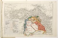
- f 31 'Map of Eastern Turkey in Asia, Syria and Western Persia [Iran]'. With international boundary annotations. 1917-20?
- f 32 'Map of Eastern Turkey in Asia, Syria and Western Persia'. With repatriation annotations. 1917-20?
- ff 33-34 'Map of Eastern Turkey in Asia, Syria and Western Persia'. With overprints Additional information printed on to an existing map. showing ethnic information, boundaries and communications. 1917-20?
- ff 35-35a 'Map of Eastern Turkey in Asia, Syria and Western Persia (Ethnographical)' with attached key. 1917-19
- f 36 [Map of Eastern Turkey in Asia, Syria and Western Persia]. Fragment of south-east corner, with additional railway information. 1917-18
- f 37 'Arménie. Dressèe par le Capitaine de Corvette Z. Khanzadian' [1919]
- f 38 'Map to show territory which was Turkish prior to War 1914-'18 which it is proposed to include within Northern, Western and Southern Boundaries of Armenia.' Created by the Geographical Section, General Staff, 1920
- f 39 'Persia and Afghanistan'. With manuscript additions showing 'Persian Territorial Claims'. 1919-1919?
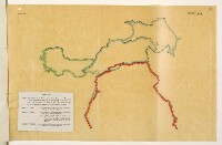
- ff 40-40a 'Caucasus Boundaries' with attached note. [1919]
- f 41 'Tabriz'. Created by the Royal Geographical Society and the War Office. With manuscript additions. 1916-20
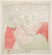
- f 42 'The Middle East'. Published by 'Admiralty War Staff I[ntelligence].D[ivision].' With manuscript additions showing Arabic language areas. [1917]
- f 43 'The Middle East'. Published by 'Admiralty War Staff I[ntelligence].D[ivision].' With manuscript additions showing areas of British direct control and spheres of special political influence. [1917]
- f 44 'Syria. Jaffa – Damascus'. Published by the War Office. With manuscript additions showing boundary information. 1916-[1920?].
- Extent and format
- 42 map sheets and 8 folios
- It is grouped into
- 2 imagesRef: Mss Eur F112/570, f 12 imagesRef: Mss Eur F112/570, f 24 imagesRef: Mss Eur F112/570, ff 3-42 imagesRef: Mss Eur F112/570, f 52 imagesRef: Mss Eur F112/570, f 62 imagesRef: Mss Eur F112/570, f 72 imagesRef: Mss Eur F112/570, f 82 imagesRef: Mss Eur F112/570, f 92 imagesRef: Mss Eur F112/570, f 102 imagesRef: Mss Eur F112/570, f 116 imagesRef: Mss Eur F112/570, ff 12-144 imagesRef: Mss Eur F112/570, ff 15-1614 imagesRef: Mss Eur F112/570, ff 17-232 imagesRef: Mss Eur F112/570, f 192 imagesRef: Mss Eur F112/570, f 202 imagesRef: Mss Eur F112/570, f 212 imagesRef: Mss Eur F112/570, f 2216 imagesRef: Mss Eur F112/570, ff 24-302 imagesRef: Mss Eur F112/570, f 262 imagesRef: Mss Eur F112/570, f 272 imagesRef: Mss Eur F112/570, f 282 imagesRef: Mss Eur F112/570, f 292 imagesRef: Mss Eur F112/570, f 312 imagesRef: Mss Eur F112/570, f 324 imagesRef: Mss Eur F112/570, ff 33-343 imagesRef: Mss Eur F112/570, ff 35-35a2 imagesRef: Mss Eur F112/570, f 362 imagesRef: Mss Eur F112/570, f 372 imagesRef: Mss Eur F112/570, f 382 imagesRef: Mss Eur F112/570, f 393 imagesRef: Mss Eur F112/570, ff 40-40a2 imagesRef: Mss Eur F112/570, f 412 imagesRef: Mss Eur F112/570, f 422 imagesRef: Mss Eur F112/570, f 432 imagesRef: Mss Eur F112/570, f 44
- Written in
- English, French and Italian in Latin script
- Type
- Archival file
Archive information for this record
- Original held at
- British Library: India Office The department of the British Government to which the Government of India reported between 1858 and 1947. The successor to the Court of Directors. Records and Private Papers Documents collected in a private capacity.
- Access conditions
Unrestricted
- Archive reference
- Mss Eur F112/570
- Date(s)
- Early 1890s-1920? (CE, Gregorian)
- Related primary sources
A political background to the re-alignment of boundaries in this region is given in:
- David Fromkin, A Peace to End all Peace: Creating the Modern Middle East 1914-22 (London: André Deutsch, 1989).
Access & Reference
History of this record
Related material
Related search terms
- Subjects
- Boundaries
- Places
- Ottoman Empire
Use and share this record
- Share this record
- Cite this record in your research
Maps and Associated Documents Relating to the Post-war Realignment of Boundaries in the Former Ottoman Empire, British Library: India Office Records and Private Papers, Mss Eur F112/570, in Qatar Digital Library <https://www.qdl.qa/archive/81055/vdc_100000001491.0x0002da> [accessed 15 July 2026]
- Link to this record
https://www.qdl.qa/en/archive/81055/vdc_100000001491.0x0002da
- IIIF details
This record has a IIIF manifest available as follows. If you have a compatible viewer you can drag the icon to load it.https://www.qdl.qa/en/iiif/81055/vdc_100000001491.0x0002da/manifestOpen in Universal viewerOpen in Mirador viewerMore options for embedding images
Copyright: How to use this content
- Reference
- Mss Eur F112/570, f 1
- Title
- 'Sketch Map of Asia Minor, showing approximate course of Roads and Railways'. With boundary additions
- Pages
- 1r:1v
- Author
- Emery Walker Ltd
- Usage terms
- The copyright status is unknown. Please contact [email protected] with any information you have regarding this item.
- Reference
- Mss Eur F112/570, f 2
- Title
- Western Turkey, Showing the Zone of the High Commissioner and Areas Ceded to Greece and Italy
- Pages
- 2r:2v
- Author
- Unknown
- Usage terms
- The copyright status is unknown. Please contact [email protected] with any information you have regarding this item.
- Reference
- Mss Eur F112/570, ff 3-4
- Title
- 'Boundary of Demilitarized Zone about Constantinople. (Meeting of Allied Naval & Military Advisors, London 16.2.20.)'
- Pages
- 3r:4v
- Author
- War Office
- Usage terms
- Open Government Licence
- Reference
- Mss Eur F112/570, f 5
- Title
- 'Izmir (Smyrna)'. With boundaries added in manuscript
- Pages
- 5r:5v
- Author
- Royal Geographical Society
- Usage terms
- Public Domain
- Reference
- Mss Eur F112/570, f 5
- Title
- 'Izmir (Smyrna)'. With boundaries added in manuscript
- Pages
- 5r:5v
- Author
- War Office
- Usage terms
- Public Domain
- Reference
- Mss Eur F112/570, f 5
- Title
- 'Izmir (Smyrna)'. With boundaries added in manuscript
- Pages
- 5r:5v
- Author
- Unknown annotator
- Usage terms
- The copyright status is unknown. Please contact [email protected] with any information you have regarding this item.
- Reference
- Mss Eur F112/570, f 6
- Title
- 'Anatolia'. With boundaries added to 20 February 1920
- Pages
- 6r:6v
- Author
- War Office
- Usage terms
- Public Domain
- Reference
- Mss Eur F112/570, f 7
- Title
- 'Anatolia'. With boundaries and proposed boundaries added to 30 March 1920
- Pages
- 7r:7v
- Author
- War Office
- Usage terms
- Public Domain
- Reference
- Mss Eur F112/570, f 8
- Title
- 'Map No. 1. Turkey in Europa. Zone of the Straits, Smyrna, the [Aegean] Islands'
- Pages
- 8r:8v
- Author
- France, Institut Géographique National xx France, Service Géographique de l'Armée
- Usage terms
- Public Domain
- Reference
- Mss Eur F112/570, f 8
- Title
- 'Map No. 1. Turkey in Europa. Zone of the Straits, Smyrna, the [Aegean] Islands'
- Pages
- 8r:8v
- Author
- Unknown annotator
- Usage terms
- The copyright status is unknown. Please contact [email protected] with any information you have regarding this item.
- Reference
- Mss Eur F112/570, f 8
- Title
- 'Map No. 1. Turkey in Europa. Zone of the Straits, Smyrna, the [Aegean] Islands'
- Pages
- 8r:8v
- Author
- War Office
- Usage terms
- Public Domain
- Reference
- Mss Eur F112/570, f 9
- Title
- 'A Map of Turkey in Asia'. Proposed division of Ottoman Empire after the First World War
- Pages
- 9r:9v
- Author
- Unknown
- Usage terms
- The copyright status is unknown. Please contact [email protected] with any information you have regarding this item.
- Reference
- Mss Eur F112/570, f 10
- Title
- 'Map to illustrate the Agreements of 1916 in regard to Asia Minor, Mesopotamia, &c.'
- Pages
- 10r:10v
- Author
- Edward Stanford & Co, publishers and stationers
- Copyright
- ©Edward Stanford Limited
- Usage terms
- Creative Commons Non-Commercial Licence
- Reference
- Mss Eur F112/570, f 10
- Title
- 'Map to illustrate the Agreements of 1916 in regard to Asia Minor, Mesopotamia, &c.'
- Pages
- 10r:10v
- Author
- Unknown annotator
- Usage terms
- The copyright status is unknown. Please contact [email protected] with any information you have regarding this item.
- Reference
- Mss Eur F112/570, f 11
- Title
- 'Map to illustrate the Agreements of 1916 in regard to Asia Minor, Mesopotamia, &c.'
- Pages
- 11r:11v
- Author
- Foreign Office
- Usage terms
- Public Domain
- Reference
- Mss Eur F112/570, f 11
- Title
- 'Map to illustrate the Agreements of 1916 in regard to Asia Minor, Mesopotamia, &c.'
- Pages
- 11r:11v
- Author
- Harrison and Sons Ltd
- Usage terms
- Public Domain
- Reference
- Mss Eur F112/570, f 11
- Title
- 'Map to illustrate the Agreements of 1916 in regard to Asia Minor, Mesopotamia, &c.'
- Pages
- 11r:11v
- Author
- Unknown annotator
- Usage terms
- The copyright status is unknown. Please contact [email protected] with any information you have regarding this item.
- Reference
- Mss Eur F112/570, f 11
- Title
- 'Map to illustrate the Agreements of 1916 in regard to Asia Minor, Mesopotamia, &c.'
- Pages
- 11r:11v
- Author
- Edward Stanford & Co, publishers and stationers
- Copyright
- ©Edward Stanford Limited
- Usage terms
- Creative Commons Non-Commercial Licence
- Reference
- Mss Eur F112/570, ff 12-14
- Title
- 'Map to illustrate the Agreements of 1916 in regard to Asia Minor, Mesopotamia, &c.'
- Pages
- 12r:14v
- Author
- Foreign Office
- Usage terms
- Public Domain
- Reference
- Mss Eur F112/570, ff 12-14
- Title
- 'Map to illustrate the Agreements of 1916 in regard to Asia Minor, Mesopotamia, &c.'
- Pages
- 12r:14v
- Author
- Harrison and Sons Ltd
- Usage terms
- Public Domain
- Reference
- Mss Eur F112/570, ff 12-14
- Title
- 'Map to illustrate the Agreements of 1916 in regard to Asia Minor, Mesopotamia, &c.'
- Pages
- 12r:14v
- Author
- Unknown annotator
- Usage terms
- The copyright status is unknown. Please contact [email protected] with any information you have regarding this item.
- Reference
- Mss Eur F112/570, ff 12-14
- Title
- 'Map to illustrate the Agreements of 1916 in regard to Asia Minor, Mesopotamia, &c.'
- Pages
- 12r:14v
- Author
- Edward Stanford & Co, publishers and stationers
- Copyright
- ©Edward Stanford Limited
- Usage terms
- Creative Commons Non-Commercial Licence
- Reference
- Mss Eur F112/570, ff 15-16
- Title
- 'Map to illustrate the Agreements of 1916.' Turkey in Asia
- Pages
- 15r:16v
- Author
- Edward Stanford & Co, publishers and stationers
- Usage terms
- Public Domain
- Reference
- Mss Eur F112/570, ff 17-23
- Title
- 'Maps illustrating Memorandum respecting the Settlement of Turkey and the Arabian Peninsula.'
- Pages
- 17r:23v
- Author
- Foreign Office, Political Intelligence Department
- Usage terms
- Public Domain
- Reference
- Mss Eur F112/570, ff 17-23
- Title
- 'Maps illustrating Memorandum respecting the Settlement of Turkey and the Arabian Peninsula.'
- Pages
- 19r:19v
- Author
- Harrison and Sons Ltd
- Usage terms
- Public Domain
- Reference
- Mss Eur F112/570, ff 17-23
- Title
- 'Maps illustrating Memorandum respecting the Settlement of Turkey and the Arabian Peninsula.'
- Pages
- 19r:19v
- Author
- Foreign Office
- Usage terms
- Public Domain
- Reference
- Mss Eur F112/570, ff 17-23
- Title
- 'Maps illustrating Memorandum respecting the Settlement of Turkey and the Arabian Peninsula.'
- Pages
- 19r:19v, 21r:22v
- Author
- Edward Stanford & Co, publishers and stationers
- Copyright
- ©Edward Stanford Limited
- Usage terms
- Creative Commons Non-Commercial Licence
- Reference
- Mss Eur F112/570, f 19
- Title
- 'Map 1. Map to illustrate the Agreements of 1916 in regard to Asia Minor, Mesopotamia, &c.'
- Pages
- 19r:19v
- Author
- Foreign Office
- Usage terms
- Public Domain
- Reference
- Mss Eur F112/570, f 19
- Title
- 'Map 1. Map to illustrate the Agreements of 1916 in regard to Asia Minor, Mesopotamia, &c.'
- Pages
- 19r:19v
- Author
- Harrison and Sons Ltd
- Usage terms
- Public Domain
- Reference
- Mss Eur F112/570, f 19
- Title
- 'Map 1. Map to illustrate the Agreements of 1916 in regard to Asia Minor, Mesopotamia, &c.'
- Pages
- 19r:19v
- Author
- Edward Stanford & Co, publishers and stationers
- Copyright
- ©Edward Stanford Limited
- Usage terms
- Creative Commons Non-Commercial Licence
- Reference
- Mss Eur F112/570, f 19
- Title
- 'Map 1. Map to illustrate the Agreements of 1916 in regard to Asia Minor, Mesopotamia, &c.'
- Pages
- 19r:19v
- Author
- Foreign Office, Political Intelligence Department
- Usage terms
- Public Domain
- Reference
- Mss Eur F112/570, f 20
- Title
- 'Map 2A. Areas in which it is hoped that the Peoples of Turkey, Arabia, and the Caucasus, if they group themselves on the lines indicated in Map 2, will subsequently opt for the respective assistance of the Allied Powers.'
- Pages
- 20r:20v
- Author
- Foreign Office, Political Intelligence Department
- Usage terms
- Public Domain
- Reference
- Mss Eur F112/570, f 21
- Title
- 'Map 2. Possible Redistribution of Ottoman and Arabian Territory on the Principle of Self-Determination.'
- Pages
- 21r:21v
- Author
- Edward Stanford & Co, publishers and stationers
- Usage terms
- Public Domain
- Reference
- Mss Eur F112/570, f 21
- Title
- 'Map 2. Possible Redistribution of Ottoman and Arabian Territory on the Principle of Self-Determination.'
- Pages
- 21r:21v
- Author
- Foreign Office, Political Intelligence Department
- Usage terms
- Public Domain
- Reference
- Mss Eur F112/570, f 22
- Title
- 'Map 3. Possible Settlement of Arab Countries.'
- Pages
- 22r:22v
- Author
- Edward Stanford & Co, publishers and stationers
- Usage terms
- Public Domain
- Reference
- Mss Eur F112/570, f 22
- Title
- 'Map 3. Possible Settlement of Arab Countries.'
- Pages
- 22r:22v
- Author
- Foreign Office, Political Intelligence Department
- Usage terms
- Public Domain
- Reference
- Mss Eur F112/570, ff 24-30
- Title
- 'Maps illustrating Memorandum respecting the Settlement of Turkey and the Arabian Peninsula.'
- Pages
- 24r:30v
- Author
- Foreign Office, Political Intelligence Department
- Usage terms
- Public Domain
- Reference
- Mss Eur F112/570, ff 24-30
- Title
- 'Maps illustrating Memorandum respecting the Settlement of Turkey and the Arabian Peninsula.'
- Pages
- 26r:26v
- Author
- Foreign Office
- Usage terms
- Public Domain
- Reference
- Mss Eur F112/570, ff 24-30
- Title
- 'Maps illustrating Memorandum respecting the Settlement of Turkey and the Arabian Peninsula.'
- Pages
- 26r:26v
- Author
- Harrison and Sons Ltd
- Usage terms
- Public Domain
- Reference
- Mss Eur F112/570, ff 24-30
- Title
- 'Maps illustrating Memorandum respecting the Settlement of Turkey and the Arabian Peninsula.'
- Pages
- 26r:26v, 28r:29v
- Author
- Edward Stanford & Co, publishers and stationers
- Copyright
- ©Edward Stanford Limited
- Usage terms
- Creative Commons Non-Commercial Licence
- Reference
- Mss Eur F112/570, f 26
- Title
- 'Map 1. Map to illustrate the Agreements of 1916 in regard to Asia Minor, Mesopotamia, &c.'
- Pages
- 26r:26v
- Author
- Foreign Office
- Usage terms
- Public Domain
- Reference
- Mss Eur F112/570, f 26
- Title
- 'Map 1. Map to illustrate the Agreements of 1916 in regard to Asia Minor, Mesopotamia, &c.'
- Pages
- 26r:26v
- Author
- Foreign Office, Political Intelligence Department
- Usage terms
- Public Domain
- Reference
- Mss Eur F112/570, f 26
- Title
- 'Map 1. Map to illustrate the Agreements of 1916 in regard to Asia Minor, Mesopotamia, &c.'
- Pages
- 26r:26v
- Author
- Harrison and Sons Ltd
- Usage terms
- Public Domain
- Reference
- Mss Eur F112/570, f 26
- Title
- 'Map 1. Map to illustrate the Agreements of 1916 in regard to Asia Minor, Mesopotamia, &c.'
- Pages
- 26r:26v
- Author
- Edward Stanford & Co, publishers and stationers
- Copyright
- ©Edward Stanford Limited
- Usage terms
- Creative Commons Non-Commercial Licence
- Reference
- Mss Eur F112/570, f 27
- Title
- 'Map 2A. Areas in which it is hoped that the Peoples of Turkey, Arabia, and the Caucasus, if they group themselves on the lines indicated in Map 2, will subsequently opt for the respective assistance of the Allied Powers.'
- Pages
- 27r:27v
- Author
- Foreign Office, Political Intelligence Department
- Usage terms
- Public Domain
- Reference
- Mss Eur F112/570, f 28
- Title
- 'Map 2. Possible Redistribution of Ottoman and Arabian Territory on the Principle of Self-Determination.'
- Pages
- 28r:28v
- Author
- Foreign Office, Political Intelligence Department
- Usage terms
- Public Domain
- Reference
- Mss Eur F112/570, f 28
- Title
- 'Map 2. Possible Redistribution of Ottoman and Arabian Territory on the Principle of Self-Determination.'
- Pages
- 28r:28v
- Author
- Edward Stanford & Co, publishers and stationers
- Usage terms
- Public Domain
- Reference
- Mss Eur F112/570, f 29
- Title
- 'Map 3. Possible Settlement of Arab Countries.'
- Pages
- 29r:29v
- Author
- Foreign Office, Political Intelligence Department
- Usage terms
- Public Domain
- Reference
- Mss Eur F112/570, f 29
- Title
- 'Map 3. Possible Settlement of Arab Countries.'
- Pages
- 29r:29v
- Author
- Edward Stanford & Co, publishers and stationers
- Usage terms
- Public Domain
- Reference
- Mss Eur F112/570, f 31
- Title
- 'Map of Eastern Turkey in Asia, Syria and Western Persia'. With international boundary annotations
- Pages
- 31r:31v
- Author
- Unknown annotator
- Usage terms
- The copyright status is unknown. Please contact [email protected] with any information you have regarding this item.
- Reference
- Mss Eur F112/570, f 31
- Title
- 'Map of Eastern Turkey in Asia, Syria and Western Persia'. With international boundary annotations
- Pages
- 31r:31v
- Author
- Royal Geographical Society
- Usage terms
- Public Domain
- Reference
- Mss Eur F112/570, f 32
- Title
- 'Map of Eastern Turkey in Asia, Syria and Western Persia'. With repatriation annotations
- Pages
- 32r:32v
- Author
- Unknown annotator
- Usage terms
- The copyright status is unknown. Please contact [email protected] with any information you have regarding this item.
- Reference
- Mss Eur F112/570, f 32
- Title
- 'Map of Eastern Turkey in Asia, Syria and Western Persia'. With repatriation annotations
- Pages
- 32r:32v
- Author
- Royal Geographical Society
- Usage terms
- Public Domain
- Reference
- Mss Eur F112/570, ff 33-34
- Title
- 'Map of Eastern Turkey in Asia, Syria and Western Persia'. With overprints showing ethnic information, boundaries and communications
- Pages
- 33r:34v
- Author
- Royal Geographical Society
- Usage terms
- Public Domain
- Reference
- Mss Eur F112/570, ff 35-35a
- Title
- 'Map of Eastern Turkey in Asia, Syria and Western Persia (Ethnographical)' showing additional frontiers with attached key
- Pages
- 35r:35v
- Author
- Royal Geographical Society
- Usage terms
- Public Domain
- Reference
- Mss Eur F112/570, ff 35-35a
- Title
- 'Map of Eastern Turkey in Asia, Syria and Western Persia (Ethnographical)' showing additional frontiers with attached key
- Pages
- 35ar
- Author
- War Office
- Usage terms
- Public Domain
- Reference
- Mss Eur F112/570, f 36
- Title
- Map of Eastern Turkey in Asia, Syria and Western Persia. Fragment of south-east corner, with additional railway information
- Pages
- 36r:36v
- Author
- Unknown annotator
- Usage terms
- The copyright status is unknown. Please contact [email protected] with any information you have regarding this item.
- Reference
- Mss Eur F112/570, f 36
- Title
- Map of Eastern Turkey in Asia, Syria and Western Persia. Fragment of south-east corner, with additional railway information
- Pages
- 36r:36v
- Author
- Royal Geographical Society
- Copyright
- ©Royal Geographical Society
- Usage terms
- Creative Commons Non-Commercial Licence
- Reference
- Mss Eur F112/570, f 37
- Title
- 'Arménie. Dressèe par le Capitaine de Corvette Z. Khanzadian'
- Pages
- 37r:37v
- Author
- A Gentil
- Usage terms
- Public Domain
- Reference
- Mss Eur F112/570, f 37
- Title
- 'Arménie. Dressèe par le Capitaine de Corvette Z. Khanzadian'
- Pages
- 37r:37v
- Author
- Délégation Nationale Arménienne
- Usage terms
- Public Domain
- Reference
- Mss Eur F112/570, f 37
- Title
- 'Arménie. Dressèe par le Capitaine de Corvette Z. Khanzadian'
- Pages
- 37r:37v
- Author
- Khanzadian, Zadig xx Xanzatean, Zatik
- Usage terms
- The copyright status is unknown. Please contact [email protected] with any information you have regarding this item.
- Reference
- Mss Eur F112/570, f 38
- Title
- 'Map to show territory which was Turkish prior to War 1914-'18 which it is proposed to include within Northern, Western and Southern Boundaries of Armenia.'
- Pages
- 38r:38v
- Author
- War Office
- Usage terms
- Public Domain
- Reference
- Mss Eur F112/570, f 39
- Title
- 'Persia and Afghanistan'. With manuscript additions showing 'Persian Territorial Claims'
- Pages
- 39r:39v
- Author
- Unknown annotator
- Usage terms
- The copyright status is unknown. Please contact [email protected] with any information you have regarding this item.
- Reference
- Mss Eur F112/570, f 39
- Title
- 'Persia and Afghanistan'. With manuscript additions showing 'Persian Territorial Claims'
- Pages
- 39r:39v
- Author
- War Office
- Usage terms
- Public Domain
- Reference
- Mss Eur F112/570, ff 40-40a
- Title
- 'Caucasus Boundaries'
- Pages
- 40r:40v
- Author
- Malby and Sons
- Usage terms
- Public Domain
- Reference
- Mss Eur F112/570, ff 40-40a
- Title
- 'Caucasus Boundaries'
- Pages
- 40r:40v
- Author
- War Office
- Usage terms
- Public Domain
- Reference
- Mss Eur F112/570, ff 40-40a
- Title
- 'Caucasus Boundaries'
- Pages
- 40r:40ar
- Author
- Unknown annotator
- Usage terms
- The copyright status is unknown. Please contact [email protected] with any information you have regarding this item.
- Reference
- Mss Eur F112/570, ff 40-40a
- Title
- 'Caucasus Boundaries'
- Pages
- 40ar:40ar
- Author
- Unknown
- Usage terms
- The copyright status is unknown. Please contact [email protected] with any information you have regarding this item.
- Reference
- Mss Eur F112/570, f 41
- Title
- 'Tabriz'. With manuscript additions
- Pages
- 41r:41v
- Author
- War Office
- Usage terms
- Public Domain
- Reference
- Mss Eur F112/570, f 41
- Title
- 'Tabriz'. With manuscript additions
- Pages
- 41r:41v
- Author
- Royal Geographical Society
- Usage terms
- Public Domain
- Reference
- Mss Eur F112/570, f 41
- Title
- 'Tabriz'. With manuscript additions
- Pages
- 41r:41v
- Author
- Unknown annotator
- Usage terms
- The copyright status is unknown. Please contact [email protected] with any information you have regarding this item.
- Reference
- Mss Eur F112/570, f 42
- Title
- 'The Middle East'. With manuscript additions showing Arabic language areas
- Pages
- 42r:42v
- Author
- Admiralty War Staff, Naval Intelligence Division
- Usage terms
- Public Domain
- Reference
- Mss Eur F112/570, f 42
- Title
- 'The Middle East'. With manuscript additions showing Arabic language areas
- Pages
- 42r:42v
- Author
- Unknown annotator
- Usage terms
- The copyright status is unknown. Please contact [email protected] with any information you have regarding this item.
- Reference
- Mss Eur F112/570, f 43
- Title
- 'The Middle East'. With manuscript additions showing areas of British direct control and spheres of special political influence
- Pages
- 43r:43v
- Author
- Admiralty War Staff, Naval Intelligence Division
- Usage terms
- Public Domain
- Reference
- Mss Eur F112/570, f 43
- Title
- 'The Middle East'. With manuscript additions showing areas of British direct control and spheres of special political influence
- Pages
- 43r:43v
- Author
- Unknown annotator
- Usage terms
- The copyright status is unknown. Please contact [email protected] with any information you have regarding this item.
- Reference
- Mss Eur F112/570, f 44
- Title
- 'Syria. Jaffa - Damascus'. With manuscript additions showing boundary information
- Pages
- 44r:44v
- Author
- War Office
- Usage terms
- Public Domain
- Reference
- Mss Eur F112/570, f 44
- Title
- 'Syria. Jaffa - Damascus'. With manuscript additions showing boundary information
- Pages
- 44r:44v
- Author
- Unknown annotator
- Usage terms
- The copyright status is unknown. Please contact [email protected] with any information you have regarding this item.