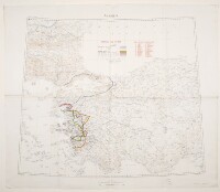
'Anatolia'. With boundaries added to 20 February 1920
Mss Eur F112/570, f 6
2 items in this record
Search within this record
The record is made up of 1 map sheet. It was created in 1919-1920. It was written in English. The original is part of the British Library: India Office The department of the British Government to which the Government of India reported between 1858 and 1947. The successor to the Court of Directors. Records and Private Papers Documents collected in a private capacity. .
About this record
- Content
Relates to the Treaty of Sèvres (1920)
Created by the War Office August 1919 with boundaries added to 20 February 1920. Geographical Section, General Staff No. 2931, Sheet ' Anatolia Peninsula that forms most of modern-day Turkey. '. Portrays hydrology, soundings Measurements of the depth of a body of water. , relief by spot heights A point on a map at which the height of the land is recorded. and contours, railways, settlements, place names, and international and internal boundaries. Base map A map portraying background detail. compiled from GSGS 2555 sheets NJ-35 (dated 1916), NJ-36 (1916), NK-35 (1919) and NK-36 (1916); projection Any method by which the earth’s curved surface may be transposed (or projected) on to a flat surface. information also derived from this source.
Colour overprints Additional information printed on to an existing map. , partly compiled from the information in folio 5, cover the Izmir (Smyrna) and Istambul [Istanbul] areas of western Turkey and depict boundaries of Vilayets, Sanjaks and Kazas; General Milne's Line; Line of Paris Greek Commission; Line of London Smyrna Commission; Line showing Greek claim of 19 February 1920; Line of Turkish Demilitarized Zone [Zone of the Straits]; and percentages of Races for complete Kazas, together with a list of Kazas.
Verso The back of a sheet of paper or leaf, often abbreviated to 'v'. bears the annotation 'Dardanelles'.
- Extent and format
- 1 map sheet
- Area map covers
- Map loading...
- Scale
- Scale 1:1,500,000
- Scale designator
- Horizontal
- Orientation
- North
- Degree coordinates
- Top-left: 44° 0' 0" N, 24° 0' 0" E
Top-right: 44° 0' 0" N, 36° 0' 0" E
Bottom-left: 36° 0' 0" N, 24° 0' 0" E
Bottom-right: 36° 0' 0" N, 36° 0' 0" E - It is part of
- 90 imagesRef: Mss Eur F112/570
- Physical characteristics
Materials: Printed in colour, with manuscript additions in pencil
Dimensions: 595 x 722mm, on sheet 713 x 830mm
- Written in
- English in Latin script
- Type
- Map
Archive information for this record
- Original held at
- British Library: India Office The department of the British Government to which the Government of India reported between 1858 and 1947. The successor to the Court of Directors. Records and Private Papers Documents collected in a private capacity.
- Access conditions
Unrestricted
- Archive reference
- Mss Eur F112/570, f 6
- Date(s)
- 1919-1920 (CE, Gregorian)
- Related primary sources
The Treaty of Sèvres can be found at:
- Treaty Series No. 11 (1920), Treaty of Peace with Turkey. Signed at Sèvres, August 10, 1920 (London: His Majesty’s Stationery Office, 1920) filed at OP-fCmd.964.
The Treaty of Sèvres and an analysis thereof can be found at:
- Carnegie Endowment for International Peace, The Treaties of Peace, 1919-1923 (New York: Carnegie Endowment for International Peace, 1924) filed at Ac.2297.h/4.
Access & Reference
History of this record
Related material
Related search terms
- Subjects
- Treaty of Sèvres (1920)
- Places
- TurkeyZone of the StraitsIzmirIstambulAnatoliaDardanelles
- People & organisations
- War Office
Use and share this record
- Share this record
- Cite this record in your research
'Anatolia'. With boundaries added to 20 February 1920, British Library: India Office Records and Private Papers, Mss Eur F112/570, f 6, in Qatar Digital Library <https://www.qdl.qa/archive/81055/vdc_100140102009.0x000002> [accessed 16 July 2026]
- Link to this record
https://www.qdl.qa/en/archive/81055/vdc_100140102009.0x000002
- IIIF details
This record has a IIIF manifest available as follows. If you have a compatible viewer you can drag the icon to load it.https://www.qdl.qa/en/iiif/81055/vdc_100000001491.0x0002da/manifestOpen in Universal viewerOpen in Mirador viewerMore options for embedding images
Copyright: How to use this content
- Reference
- Mss Eur F112/570, f 6
- Title
- 'Anatolia'. With boundaries added to 20 February 1920
- Pages
- 6r:6v
- Author
- War Office
- Usage terms
- Public Domain
