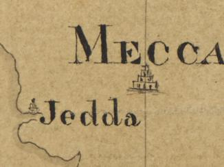
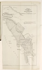
'Sketch Map schewing Tribal Districts between Arabistan and Bushire'
IOR/L/PS/10/485, f 135
2 items in this record
Search within this record
The record is made up of 1 map. It was created in Jul 1915. It was written in English. The original is part of the British Library: India Office The department of the British Government to which the Government of India reported between 1858 and 1947. The successor to the Court of Directors. Records and Private Papers Documents collected in a private capacity. .
About this record
- Content
The map shows the area between Arabistan and Bushire, indicating the regions inhabited by the following tribes: Lirawi, Hajat Daoud, Shabankareh, Zira, Borasju, Rudhilleh, Angali, Chahkutah, and Tangistan.
These districts are categorised as 'in cooperation with British Authorities', 'in alliance with Hayat Daoud [Ḥayāt-dāwudi]', and 'hostile to British'.
The map also shows the Zeidun district in the North, administered by the Sheikh of Maohammerah.
Hydrology, hachures, some roads and railway routes are also indicated.
The map was produced by General Staff, India.
Scale approximately 1:519,000
- Extent and format
- 1 map
- Area map covers
- Map loading...
- Scale
- 1:519,000 approx
- Scale designator
- Horizontal
- Orientation
- North
- Degree coordinates
- Top-left: 30° 43' 50.16" N, 49° 40' 23.88" E
Top-right: 30° 43' 50.16" N, 51° 32' 12.84" E
Bottom-left: 28° 21' 55.44" N, 49° 40' 23.88" E
Bottom-right: 28° 21' 55.44" N, 51° 32' 12.84" E - It is part of
- 434 imagesRef: IOR/L/PS/10/485
- Physical characteristics
Materials: Printed on paper
Dimensions: 591 x 360mm
- Written in
- English in Latin script
- Type
- Map
Archive information for this record
- Original held at
- British Library: India Office The department of the British Government to which the Government of India reported between 1858 and 1947. The successor to the Court of Directors. Records and Private Papers Documents collected in a private capacity.
- Access conditions
Unrestricted
- Archive reference
- IOR/L/PS/10/485, f 135
- Former external reference(s)
- W/LPS/21/B50 B50
- Date(s)
- Jul 1915 (CE, Gregorian)
Access & Reference
History of this record
Related search terms
- Places
- ArabistanBushire
- People & organisations
- Emir of Mohammerah
Use and share this record
- Share this record
- Cite this record in your research
'Sketch Map schewing Tribal Districts between Arabistan and Bushire', British Library: India Office Records and Private Papers, IOR/L/PS/10/485, f 135, in Qatar Digital Library <https://www.qdl.qa/archive/81055/vdc_100049434816.0x000001> [accessed 30 June 2024]
- Link to this record
https://www.qdl.qa/en/archive/81055/vdc_100049434816.0x000001
- IIIF details
This record has a IIIF manifest available as follows. If you have a compatible viewer you can drag the icon to load it.https://www.qdl.qa/en/iiif/81055/vdc_100000000419.0x00017c/manifestOpen in Universal viewerOpen in Mirador viewerMore options for embedding images
Copyright: How to use this content
- Reference
- IOR/L/PS/10/485, f 135
- Title
- 'Sketch Map schewing Tribal Districts between Arabistan and Bushire'
- Pages
- 135r:135v
- Author
- East India Company, the Board of Control, the India Office, or other British Government Department
- Usage terms
- Open Government Licence