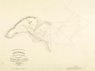
‘Trigonometrical Survey of the Arabian or Southern Side of the Persian Gulf By Lieutenants J.M. Guy & G.B. Brucks H.C. Marine. 1824. Drawn by Lieutt. M. Houghton Draughtsman H.C.M. Engraved by John Bateman. Sheet 3rd’
IOR/X/3630/20/5

2 items in this record
Search within this record
The record is made up of 1 map. It was created in 8 Jul 1826. It was written in English. The original is part of the British Library: Map Collections.
About this record
- Content
Imprint:
Published by James Horsburgh, Hydrographer to the East India Company.
Distinctive Features:
Relief shown by hachures. Depth shown by soundings Measurements of the depth of a body of water. .
Nautical chart of the western coast of the Persian Gulf The historical term used to describe the body of water between the Arabian Peninsula and Iran. showing the Qatar Peninsula compiled from the surveys carried out by the Bombay Marine’s officers between 1820 and 1829.
Shoals and rocks represented by crosses.
Includes notes on latitude and longitude variations and sources used in compilation of the map.
- Extent and format
- 1 map
- Area map covers
- Map loading...
- Scale
- Scale not given
- Scale designator
- Horizontal
- Orientation
- North
- Degree coordinates
- Top-left: 26° 11' 25.8" N, 50° 42' 51.48" E
Top-right: 26° 11' 25.8" N, 52° 24' 9.72" E
Bottom-left: 23° 52' 24.6" N, 50° 42' 51.48" E
Bottom-right: 23° 52' 24.6" N, 52° 24' 9.72" E - It is part of
- 60 imagesRef: IOR/X/3630
- Physical characteristics
Dimensions: 798 x 521 mm, on sheet 861 x 676 mm
- Written in
- English in Latin script
- Type
- Map
Archive information for this record
- Original held at
- British Library: Map Collections
- Access conditions
Unrestricted
- Archive reference
- IOR/X/3630/20/5
- Date(s)
- 8 Jul 1826 (CE, Gregorian)
Access & Reference
History of this record
Related search terms
- Places
- QatarShatt al ʻArab
- People & organisations
- George Edward BrucksJohn M. GuyMichael HoughtonJames HorsburghJohn Bateman
Use and share this record
- Share this record
- Cite this record in your research
‘Trigonometrical Survey of the Arabian or Southern Side of the Persian Gulf By Lieutenants J.M. Guy & G.B. Brucks H.C. Marine. 1824. Drawn by Lieutt. M. Houghton Draughtsman H.C.M. Engraved by John Bateman. Sheet 3rd’, British Library: Map Collections, IOR/X/3630/20/5, in Qatar Digital Library <https://www.qdl.qa/archive/81055/vdc_100024174406.0x00000e> [accessed 4 October 2024]
- Link to this record
https://www.qdl.qa/en/archive/81055/vdc_100024174406.0x00000e
- IIIF details
This record has a IIIF manifest available as follows. If you have a compatible viewer you can drag the icon to load it.https://www.qdl.qa/en/iiif/81055/vdc_100022840540.0x000001/manifestOpen in Universal viewerOpen in Mirador viewerMore options for embedding images
Copyright: How to use this content
- Reference
- IOR/X/3630/20/5
- Title
- ‘Trigonometrical Survey of the Arabian or Southern Side of the Persian Gulf By Lieutenants J.M. Guy & G.B. Brucks H.C. Marine. 1824. Drawn by Lieutt. M. Houghton Draughtsman H.C.M. Engraved by John Bateman. Sheet 3rd’
- Pages
- 20r:20v
- Author
- Please see item description
- Usage terms
- Public Domain