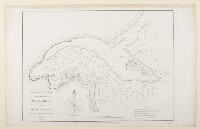
‘Trigonometrical Plan of the Harbour of Grane or Quade in the Gulf of Persia By Lieutts. J.M. Guy and G.B. Brucks H.E.I.C. Marine. 1825. Engraved by Bateman and Son’
IOR/X/3630/23
2 items in this record
Search within this record
The record is made up of 1 map. It was created in 1 Jan 1828. It was written in English. The original is part of the British Library: Map Collections.
About this record
- Content
Imprint:
Published by James Horsburgh, Hydrographer to the East India Company.
Distinctive Features:
Depth shown by soundings Measurements of the depth of a body of water. .
Nautical chart of the coast of the Kuwait Bay compiled from the surveys carried out by the Bombay Marine’s officers between 1820 and 1829.
Depicts positions for safe anchorage for shipping and boats. Contains a key and a note reporting the longitude of Grane in the lower right-hand corner.
- Extent and format
- 1 map
- Area map covers
- Map loading...
- Scale
- Scale approximately 1:130,000
- Scale designator
- Horizontal
- Orientation
- North
- Degree coordinates
- Top-left: 29° 35' 20.86" N, 47° 37' 37.03" E
Top-right: 29° 35' 20.86" N, 48° 25' 49.65" E
Bottom-left: 29° 15' 2.5" N, 47° 37' 37.03" E
Bottom-right: 29° 15' 2.5" N, 48° 25' 49.65" E - It is part of
- 60 imagesRef: IOR/X/3630
- Physical characteristics
Dimensions: 387 x 531 mm, on sheet 431 x 674 mm
- Written in
- English in Latin script
- Type
- Map
Archive information for this record
- Original held at
- British Library: Map Collections
- Access conditions
Unrestricted
- Archive reference
- IOR/X/3630/23
- Date(s)
- 1 Jan 1828 (CE, Gregorian)
Access & Reference
History of this record
Related search terms
- Places
- Kuwait Bay
- People & organisations
- George Edward BrucksJohn M. GuyJames HorsburghJohn Bateman
Use and share this record
- Share this record
- Cite this record in your research
‘Trigonometrical Plan of the Harbour of Grane or Quade in the Gulf of Persia By Lieutts. J.M. Guy and G.B. Brucks H.E.I.C. Marine. 1825. Engraved by Bateman and Son’, British Library: Map Collections, IOR/X/3630/23, in Qatar Digital Library <https://www.qdl.qa/archive/81055/vdc_100024174406.0x00000b> [accessed 12 October 2024]
- Link to this record
https://www.qdl.qa/en/archive/81055/vdc_100024174406.0x00000b
- IIIF details
This record has a IIIF manifest available as follows. If you have a compatible viewer you can drag the icon to load it.https://www.qdl.qa/en/iiif/81055/vdc_100022840540.0x000001/manifestOpen in Universal viewerOpen in Mirador viewerMore options for embedding images
Copyright: How to use this content
- Reference
- IOR/X/3630/23
- Title
- ‘Trigonometrical Plan of the Harbour of Grane or Quade in the Gulf of Persia By Lieutts. J.M. Guy and G.B. Brucks H.E.I.C. Marine. 1825. Engraved by Bateman and Son’
- Pages
- 23r:23v
- Author
- Please see item description
- Usage terms
- Public Domain