'Persia and Afghanistan. 7. Feb. 1919.'
Mss Eur F112/571, ff 1-1a

3 items in this record
Search within this record
The record is made up of 1 map sheet and 1 folio. It was created in 1919-1920. It was written in English. The original is part of the British Library: India Office The department of the British Government to which the Government of India reported between 1858 and 1947. The successor to the Court of Directors. Records and Private Papers Documents collected in a private capacity. .
About this record
- Content
Folio 1:
Classified 'Secret'.
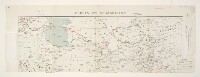
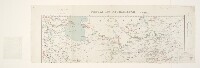
The northern half of map sheet Geographical Section, General Staff No. 2149, complete sheets bearing the imprint 'April 1912, Additions July 1918, Railways revised Jan 1919'. Sheet portrays hydrology, relief by spot heights, roads, railways, telegraphs, settlements, place names, water sources and international boundaries. This version has been printed without coloured relief plates; copies with coloured relief plates are at Maps 50970.(27.) and Maps MOD GSGS 2149.
Manuscript annotations provide details of British, Russ[ian]. and Turkoman Irregulars, and Enemy troops, a route objective, the date '7 Feb 1919', the classification 'Secret' and the note 'To accompany M[inistry].O[f].I[nformation]. J.24.' Annotated map detail covers Azerbaijan, Persia [Iran] and the Russian Soviet Federative Socialist Republic. A legend and scale bar, as would have appeared on the missing lower half of the map, have been pasted on. The verso The back of a sheet of paper or leaf, often abbreviated to 'v'. bears the annotation 'Transcaspia'.
Folio 1a:
Classified'Secret'.
Circulation list relating to Folio 1 above, to which it is attached. Printed in colour, with manuscript additions in ink. 137 x 153mm. Dated 1919-20.
- Extent and format
- 1 map sheet and 1 folio
- Area map covers
- Map loading...
- Scale
- Scale 1:4,055,040
- Scale designator
- Horizontal
- Orientation
- North
- Degree coordinates
- Top-left: 40° 40' 0.12" N, 47° 7' 59.88" E
Top-right: 40° 40' 0.12" N, 79° 19' 59.88" E
Bottom-left: 30° 49' 59.88" N, 47° 7' 59.88" E
Bottom-right: 30° 49' 59.88" N, 79° 19' 59.88" E - It is part of
- 23 imagesRef: Mss Eur F112/571
- Physical characteristics
Materials: Printed, with manuscript annotations in coloured ink and crayon
Dimensions: 262 x 764mm, on sheet 316 x 896mm
- Written in
- English in Latin script
- Type
- Map
Archive information for this record
- Original held at
- British Library: India Office The department of the British Government to which the Government of India reported between 1858 and 1947. The successor to the Court of Directors. Records and Private Papers Documents collected in a private capacity.
- Access conditions
Unrestricted
- Archive reference
- Mss Eur F112/571, ff 1-1a
- Date(s)
- 1919-1920 (CE, Gregorian)
Access & Reference
History of this record
Related search terms
Use and share this record
- Share this record
- Cite this record in your research
'Persia and Afghanistan. 7. Feb. 1919.', British Library: India Office Records and Private Papers, Mss Eur F112/571, ff 1-1a, in Qatar Digital Library <https://www.qdl.qa/archive/81055/vdc_100140102013.0x000006> [accessed 4 October 2024]
- Link to this record
https://www.qdl.qa/en/archive/81055/vdc_100140102013.0x000006
- IIIF details
This record has a IIIF manifest available as follows. If you have a compatible viewer you can drag the icon to load it.https://www.qdl.qa/en/iiif/81055/vdc_100000001491.0x0002db/manifestOpen in Universal viewerOpen in Mirador viewerMore options for embedding images
Copyright: How to use this content
- Reference
- Mss Eur F112/571, ff 1-1a
- Title
- 'Persia and Afghanistan. 7. Feb. 1919.'
- Pages
- 1r:1v, 1ar
- Author
- War Office
- Usage terms
- Open Government Licence
- Reference
- Mss Eur F112/571, ff 1-1a
- Title
- 'Persia and Afghanistan. 7. Feb. 1919.'
- Pages
- 1r:1v, 1ar
- Author
- Unknown annotator
- Usage terms
- The copyright status is unknown. Please contact [email protected] with any information you have regarding this item.