'Persian Gulf. Eastern Sheet'
IOR/X/3828/2837a
2 items in this record
Search within this record
The record is made up of 1 map sheet. It was created in 1912. It was written in English. The original is part of the British Library: Map Collections.
About this record
- Content
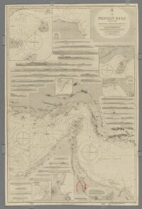
Chart 2837a.
Hydrographic chart covering the Strait of Hormuz and the adjoining sections of the Persian Gulf The historical term used to describe the body of water between the Arabian Peninsula and Iran. and Gulf of Oman. Also includes the adjacent coastal areas of Persia [Iran] and the Musandam Peninsula. Portrays hydrology, including depths by soundings Measurements of the depth of a body of water. and contours, anchorages, sands and rocks, relief by spot heights, hachures and rock drawings, vegetation, settlements, forts and place names, and includes topographical notes and navigational aids, including lights and prominent landmarks.
Includes insets of Kishm, Persia [Qeshm, Iran] at scale 1:145,826; Kais to Bandar Abbas, Persia [Kish to Bander-e Abbas] at scale 1:72,913; Henjam Island, Persia [Hengam Island] at scale 1:145,826; Charak, Persia [Bandar-e Charak] at scale 1:145,826; Chiru, Persia [Bandar-e Chiruyeh] at scale 1:72,913; Khor Fakan, Oman [Khawr Fakkan, United Arab Emirates] at scale 1:60,760; and Abu Thabi, Trucial Oman A name used by Britain from the nineteenth century to 1971 to refer to the present-day United Arab Emirates. [Abu Dhabi, United Arab Emirates] at scale 1:72,913.
Thirty-three annotated sketches of significant navigational views at unspecified scales on both the north and south coasts are also included.
Chart surveyed and compiled by Commander Charles Golding Constable and Lieutenant Arthur William Stiffe, Indian Navy (1860); also incorporates surveys by Captain John Michael Guy and Captain George Barnes Brucks, East India Marine (1821-1829); with corrections by Commander Frederic Henry Walter and Lieutenant H T Bowen, Royal Navy (1910). Engraved by J & C Walker. Published at the Admiralty 1862, with new editions 1865, 1890, 1910, 1911 and 1912, and small corrections.
The sheet bears the stamps:
'Not to be used for navigation. For reference purposes only' in red on the map face.
The number '20.2' in black in the upper right margin.
- Extent and format
- 1 map sheet
- Area map covers
- Map loading...
- Scale
- Scale approximately 1:895,000
- Scale designator
- Horizontal
- Orientation
- North
- Degree coordinates
- Top-left: 30° 48' 45" N, 53° 22' 30" E
Top-right: 30° 48' 45" N, 59° 0' 0" E
Bottom-left: 23° 10' 14.88" N, 53° 22' 30" E
Bottom-right: 23° 10' 14.88" N, 59° 0' 0" E - Physical characteristics
Materials: Printed on paper
Dimensions: 960 x 636mm, on sheet 1003 x 665mm
- Written in
- English in Latin script
- Type
- Map
Archive information for this record
- Original held at
- British Library: Map Collections
- Access conditions
Unrestricted
- Archive reference
- IOR/X/3828/2837a
- Former external reference(s)
- B 2A V II 10
- Date(s)
- 1912 (CE, Gregorian)
Access & Reference
History of this record
Related search terms
Use and share this record
- Share this record
- Cite this record in your research
'Persian Gulf. Eastern Sheet', British Library: Map Collections, IOR/X/3828/2837a, in Qatar Digital Library <https://www.qdl.qa/archive/81055/vdc_100138148395.0x000001> [accessed 5 July 2024]
- Link to this record
https://www.qdl.qa/en/archive/81055/vdc_100138148395.0x000001
- IIIF details
This record has a IIIF manifest available as follows. If you have a compatible viewer you can drag the icon to load it.https://www.qdl.qa/en/iiif/81055/vdc_100138148395.0x000001/manifestOpen in Universal viewerOpen in Mirador viewerMore options for embedding images
Copyright: How to use this content
- Reference
- IOR/X/3828/2837a
- Title
- 'Persian Gulf. Eastern Sheet'
- Pages
- 1r:1v
- Author
- Admiralty
- Usage terms
- Public Domain
- Reference
- IOR/X/3828/2837a
- Title
- 'Persian Gulf. Eastern Sheet'
- Pages
- 1r:1v
- Author
- J & C Walker
- Usage terms
- Public Domain