'Basiduh and its Approaches'
IOR/X/3828/35


2 items in this record
Search within this record
The record is made up of 1 map sheet. It was created in 1869. It was written in English. The original is part of the British Library: Map Collections.
About this record
- Content
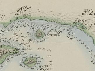
Chart 35.
Hydrographic chart covering the port of Basiduh [Basaidu] on Qeshm Island, Persia [Iran]. Also depicts the western part of Clarence [Khuran] Strait, the Persian Gulf The historical term used to describe the body of water between the Arabian Peninsula and Iran. and a fifty-mile length of the Persian mainland coast. Portrays hydrology, including depths by soundings Measurements of the depth of a body of water. and contours, sands, mud, rocks and anchorages, relief by spot heights, hachures and rock drawings, vegetation, cultivation, settlements, public buildings and place names, and includes topographical notes and navigational aids, including beacons and prominent buildings. The sheet also includes an inset A small map or other image enclosed within the margin of a larger map, map sheet, or larger image; or papers placed inside a book or archival volume. of Basiduh Anchorage at scale 1:60,500 and an annotated sketch view, at an unspecified scale, of the approach to Basiduh from the south-east.
The margins have been trimmed, with some information lost.
Chart surveyed by Commander Charles Golding. Constable, Indian Navy, and assisted by Lieutenant Arthur William Stiffe, Indian Navy, 1858-60. Soundings Measurements of the depth of a body of water. in 'hair line' from a survey by Commander George Barnes Brucks and Lieutenant Stafford Bettesworth Haines, Indian Navy, 1828. Engraved by Edward Stanford. Published at the Admiralty 1867, with corrections 1868 and 1869.
- Extent and format
- 1 map sheet
- Area map covers
- Map loading...
- Scale
- Scale 1:121,000
- Scale designator
- Horizontal
- Orientation
- North
- Degree coordinates
- Top-left: 26° 48' 15.12" N, 54° 47' 60" E
Top-right: 26° 48' 15.12" N, 55° 33' 45" E
Bottom-left: 26° 28' 45.12" N, 54° 47' 60" E
Bottom-right: 26° 28' 45.12" N, 55° 33' 45" E - Physical characteristics
Materials: Printed on paper
Dimensions: 457 x 625mm, on sheet 484 x 643mm
- Written in
- English in Latin script
- Type
- Map
Archive information for this record
- Original held at
- British Library: Map Collections
- Access conditions
Unrestricted
- Archive reference
- IOR/X/3828/35
- Former external reference(s)
- V II 13
- Date(s)
- 1869 (CE, Gregorian)
Access & Reference
History of this record
Related search terms
Use and share this record
- Share this record
- Cite this record in your research
'Basiduh and its Approaches', British Library: Map Collections, IOR/X/3828/35, in Qatar Digital Library <https://www.qdl.qa/archive/81055/vdc_100138085249.0x000001> [accessed 4 October 2024]
- Link to this record
https://www.qdl.qa/en/archive/81055/vdc_100138085249.0x000001
- IIIF details
This record has a IIIF manifest available as follows. If you have a compatible viewer you can drag the icon to load it.https://www.qdl.qa/en/iiif/81055/vdc_100138085249.0x000001/manifestOpen in Universal viewerOpen in Mirador viewerMore options for embedding images
Copyright: How to use this content
- Reference
- IOR/X/3828/35
- Title
- 'Basiduh and its Approaches'
- Pages
- 1r:1v
- Author
- Admiralty
- Usage terms
- Public Domain
- Reference
- IOR/X/3828/35
- Title
- 'Basiduh and its Approaches'
- Pages
- 1r:1v
- Author
- Stanford, Edward
- Usage terms
- Public Domain