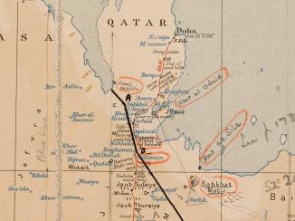
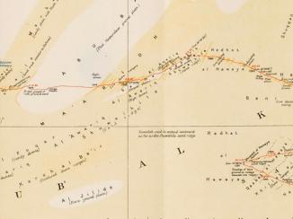
'ARABIA. Route Traverse across the RUB' AL KHALI from DHUFAR TO DOHA by BERTRAM THOMAS 1930-31'
IOR/L/PS/12/2137, f 308
2 items in this record
Search within this record
The record is made up of 1 map. It was created in Sep 1931. It was written in English. The original is part of the British Library: India Office The department of the British Government to which the Government of India reported between 1858 and 1947. The successor to the Court of Directors. Records and Private Papers Documents collected in a private capacity. .
About this record
- Content
Map published by the Royal Geographical Society. From the Geographical Journal, September 1931.
The map depicts Bertram Thomas's 1930-31 route, and earlier routes, in red. The map indicates settlements, hydrology, and also provides some indication of relief. Also included is a table of reference for symbols used on the map.
The map includes two additional lines: a line in black ink marked 'blue line' (a boundary line that formed part of the non-ratified Anglo-Ottoman Convention of 1913, and was redefined and adopted in the Anglo-Ottoman Convention of the following year), and a line in pencil outlining the suggested limits of a 'desert zone', which was considered by the British as a possible territorial concession to Saudi Arabia.
Another edition of this map can be found at IOR/R/15/2/159, f 246.
- Extent and format
- 1 map
- Area map covers
- Map loading...
- Scale
- 1:3,000,000
- Scale designator
- Horizontal
- Orientation
- North
- Projection
- Conical
- Degree coordinates
- Top-left: 26° 10' 59.16" N, 47° 47' 40.92" E
Top-right: 26° 10' 59.16" N, 60° 33' 11.52" E
Bottom-left: 16° 35' 53.88" N, 47° 47' 40.92" E
Bottom-right: 16° 35' 53.88" N, 60° 33' 11.52" E - It is part of
- 843 imagesRef: IOR/L/PS/12/2137
- Physical characteristics
Materials: Printed in colour on paper, with manuscript additions in black ink and pencil.
Dimensions: 440 x 540mm, on sheet 458 x 722mm.
- Written in
- English in Latin script
- Type
- Map
Archive information for this record
- Original held at
- British Library: India Office The department of the British Government to which the Government of India reported between 1858 and 1947. The successor to the Court of Directors. Records and Private Papers Documents collected in a private capacity.
- Access conditions
Unrestricted
- Archive reference
- IOR/L/PS/12/2137, f 308
- Date(s)
- Sep 1931 (CE, Gregorian)
Access & Reference
History of this record
Related search terms
- Places
- Rubʻ al Khālī
- People & organisations
- Royal Geographical SocietyBertram Sidney Thomas
Use and share this record
- Share this record
- Cite this record in your research
'ARABIA. Route Traverse across the RUB' AL KHALI from DHUFAR TO DOHA by BERTRAM THOMAS 1930-31', British Library: India Office Records and Private Papers, IOR/L/PS/12/2137, f 308, in Qatar Digital Library <https://www.qdl.qa/archive/81055/vdc_100049623112.0x000003> [accessed 3 April 2025]
- Link to this record
https://www.qdl.qa/en/archive/81055/vdc_100049623112.0x000003
- IIIF details
This record has a IIIF manifest available as follows. If you have a compatible viewer you can drag the icon to load it.https://www.qdl.qa/en/iiif/81055/vdc_100000000555.0x0002a3/manifestOpen in Universal viewerOpen in Mirador viewerMore options for embedding images
Copyright: How to use this content
- Reference
- IOR/L/PS/12/2137, f 308
- Title
- 'ARABIA. Route Traverse across the RUB' AL KHALI from DHUFAR TO DOHA by BERTRAM THOMAS 1930-31'
- Pages
- 308r:308v
- Author
- Royal Geographical Society
- Copyright
- ©Royal Geographical Society
- Usage terms
- Creative Commons Non-Commercial Licence


