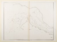
Trigonometrical Survey of Clarence’s Strait, Gulf of Persia. By Commr. G.B. Brucks and Lieutt. S.B. Haines. H.C. Marine 1828. ‘Engraved by R. Bateman. Sheet 2nd’
IOR/X/3630/28/2
2 items in this record
Search within this record
The record is made up of 1 map. It was created in 1 Sep 1831. It was written in English. The original is part of the British Library: Map Collections.
About this record
- Content
Imprint:
Published by James Horsburgh, Hydrographer to the East India Company.
Distinctive Features:
Relief shown by hachures. Depth shown by soundings Measurements of the depth of a body of water. .
Nautical chart of the Clarence Strait in the Persian Gulf The historical term used to describe the body of water between the Arabian Peninsula and Iran. compiled from the surveys carried out by the Bombay Marine’s officers between 1820 and 1829. Depicts the coastline of the mainland and the western part of the Island Kishm [Qeshm] with areas dry at low water stippled and indicated by a dotted line.
Continuation of the map entitled ‘Sheet 1’ is held at IOR/X/3630/28/1.
- Extent and format
- 1 map
- Area map covers
- Map loading...
- Scale
- Scale not given
- Scale designator
- Horizontal
- Orientation
- North
- Degree coordinates
- Top-left: 26° 48' 35.77" N, 55° 4' 13.92" E
Top-right: 26° 48' 35.77" N, 55° 33' 6.59" E
Bottom-left: 26° 29' 41.43" N, 55° 4' 13.92" E
Bottom-right: 26° 29' 41.43" N, 55° 33' 6.59" E - It is part of
- 60 imagesRef: IOR/X/3630
- Physical characteristics
Dimensions: 526 x 699 mm, on sheet 562 x 774 mm
- Written in
- English in Latin script
- Type
- Map
Archive information for this record
- Original held at
- British Library: Map Collections
- Access conditions
Unrestricted
- Archive reference
- IOR/X/3630/28/2
- Date(s)
- 1 Sep 1831 (CE, Gregorian)
Access & Reference
History of this record
Related search terms
- Places
- KishmClarence Strait
- People & organisations
- George Edward BrucksStafford Bettesworth HainesRichard BatemanJames Horsburgh
Use and share this record
- Share this record
- Cite this record in your research
Trigonometrical Survey of Clarence’s Strait, Gulf of Persia. By Commr. G.B. Brucks and Lieutt. S.B. Haines. H.C. Marine 1828. ‘Engraved by R. Bateman. Sheet 2nd’, British Library: Map Collections, IOR/X/3630/28/2, in Qatar Digital Library <https://www.qdl.qa/archive/81055/vdc_100024174406.0x000005> [accessed 18 February 2025]
- Link to this record
https://www.qdl.qa/en/archive/81055/vdc_100024174406.0x000005
- IIIF details
This record has a IIIF manifest available as follows. If you have a compatible viewer you can drag the icon to load it.https://www.qdl.qa/en/iiif/81055/vdc_100022840540.0x000001/manifestOpen in Universal viewerOpen in Mirador viewerMore options for embedding images
Copyright: How to use this content
- Reference
- IOR/X/3630/28/2
- Title
- Trigonometrical Survey of Clarence’s Strait, Gulf of Persia. By Commr. G.B. Brucks and Lieutt. S.B. Haines. H.C. Marine 1828. ‘Engraved by R. Bateman. Sheet 2nd’
- Pages
- 29r:29v
- Author
- Please see item description
- Usage terms
- Public Domain