Chart of the Persian Gulf
IOR/X/414/221


2 items in this record
Search within this record
The record is made up of 1 map. It was created in 19th century. It was written in Dutch. The original is part of the British Library: Map Collections.
About this record
- Content
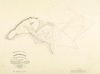
Distinctive Features:
Depths along the coasts of Persia and Oman shown by soundings Measurements of the depth of a body of water. with shoals and rocks represented by dots and crosses.
Left and bottom margins are divided and marked with numbers.
- Extent and format
- 1 map
- Area map covers
- Map loading...
- Scale
- Scale not given
- Scale designator
- Horizontal
- Orientation
- North
- Degree coordinates
- Top-left: 30° 31' 12" N, 48° 10' 48" E
Top-right: 30° 31' 12" N, 57° 17' 60" E
Bottom-left: 23° 56' 60" N, 48° 10' 48" E
Bottom-right: 23° 56' 60" N, 57° 17' 60" E - It is part of
- 8 imagesRef: IOR/X/414
- Physical characteristics
Materials:
Pen and ink with wash on tracing paper
Dimensions:
533 x 739 mm
- Written in
- Dutch in Latin script
- Type
- Map
Archive information for this record
- Original held at
- British Library: Map Collections
- Access conditions
Unrestricted
- Archive reference
- IOR/X/414/221
- Former British Library reference
- T.IV.221
- Date(s)
- 19th century (CE, Gregorian)
Access & Reference
History of this record
Related search terms
- Places
- Persian Gulf
Use and share this record
- Share this record
- Cite this record in your research
Chart of the Persian Gulf, British Library: Map Collections, IOR/X/414/221, in Qatar Digital Library <https://www.qdl.qa/archive/81055/vdc_100023807897.0x000002> [accessed 13 September 2024]
- Link to this record
https://www.qdl.qa/en/archive/81055/vdc_100023807897.0x000002
- IIIF details
This record has a IIIF manifest available as follows. If you have a compatible viewer you can drag the icon to load it.https://www.qdl.qa/en/iiif/81055/vdc_100000010890.0x000001/manifestOpen in Universal viewerOpen in Mirador viewerMore options for embedding images
Copyright: How to use this content
- Reference
- IOR/X/414/221
- Title
- Chart of the Persian Gulf
- Pages
- 3r:3v
- Author
- Please see item description
- Usage terms
- Public Domain