Four nautical charts related to the Persian Gulf and Gulf of Oman
IOR/X/414


8 items in this record
Search within this record
The record is made up of 4 manuscript charts. It was created in 19th century. It was written in Dutch. The original is part of the British Library: Map Collections.
About this record
- Content
Series of four tracings related to the Persian Gulf The historical term used to describe the body of water between the Arabian Peninsula and Iran. and Gulf of Oman copied by Frederick Charles Danvers in the late 19th century. The original charts, produced in the second half of the 17th century by an anonymous Dutch chart maker, are housed in the State Archive (Nationaal Archief), The Hague, in 'VOC – Atlas van Isaac de Graaf'.
- Extent and format
- 4 manuscript charts
- It is grouped into
- 2 imagesRef: IOR/X/414/2192 imagesRef: IOR/X/414/2202 imagesRef: IOR/X/414/2212 imagesRef: IOR/X/414/222
- Written in
- Dutch in Latin script
- Type
- Map
Archive information for this record
- Original held at
- British Library: Map Collections
- Access conditions
Unrestricted
- Archive reference
- IOR/X/414
- Date(s)
- 19th century (CE, Gregorian)
Access & Reference
History of this record
Related search terms
- People & organisations
- Frederic Charles Danvers
Use and share this record
- Share this record
- Cite this record in your research
Four nautical charts related to the Persian Gulf and Gulf of Oman, British Library: Map Collections, IOR/X/414, in Qatar Digital Library <https://www.qdl.qa/archive/81055/vdc_100000010890.0x000001> [accessed 12 July 2026]
- Link to this record
https://www.qdl.qa/en/archive/81055/vdc_100000010890.0x000001
- IIIF details
This record has a IIIF manifest available as follows. If you have a compatible viewer you can drag the icon to load it.https://www.qdl.qa/en/iiif/81055/vdc_100000010890.0x000001/manifestOpen in Universal viewerOpen in Mirador viewerMore options for embedding images
Copyright: How to use this content
- Reference
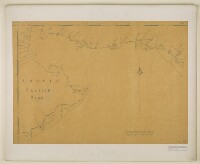
- IOR/X/414/219
- Title
- Chart of the Gulf of Oman
- Pages
- 1r:1v
- Author
- Please see item description
- Usage terms
- Public Domain
- Reference
- IOR/X/414/220
- Title
- Nautical chart of the Persian Gulf
- Pages
- 2r:2v
- Author
- Danvers, Frederick Charles
- Usage terms
- Public Domain
- Reference
- IOR/X/414/221
- Title
- Chart of the Persian Gulf
- Pages
- 3r:3v
- Author
- Please see item description
- Usage terms
- Public Domain
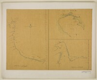
- Reference
- IOR/X/414/222
- Title
- Charts of the Gulf of Oman and Strait of Hormuz
- Pages
- 4r:4v
- Author
- Please see item description
- Usage terms
- Public Domain