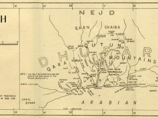
‘REDUCTION TO SHOW RELATIONSHIP of the COMBINED PLANE TABLE AND PRISMATIC COMPASS SKETCH MAP OF THE COUNTRY BETWEEN JEBEL RŌDHAH, SOHAR AND IBRI, OMAN, ARABIA, WITH THE OMAN PENINSULA’
IOR/R/15/1/625, f 18A
2 items in this record
Search within this record
The record is made up of 1 map. It was created in 1926. It was written in English. The original is part of the British Library: India Office The department of the British Government to which the Government of India reported between 1858 and 1947. The successor to the Court of Directors. Records and Private Papers Documents collected in a private capacity. .
About this record
- Content
Distinctive Features:
Relief shown by hachures and spot heights.
Includes a note on map compilation below title with a key of reference at the lower left.
On verso The back of a sheet of paper or leaf, often abbreviated to 'v'. , at the top right-hand corner: ‘OA 6021, 7-12-25’. Top left: ‘PLATE VI’. Bottom left: ‘M.R. REG., NO. 81, APRIL 1926’.
- Extent and format
- 1 map
- Area map covers
- Map loading...
- Scale
- Scale approximately 1:850,000
- Scale designator
- Horizontal
- Orientation
- North
- Degree coordinates
- Top-left: 26° 26' 40.92" N, 55° 0' 17.28" E
Top-right: 26° 26' 40.92" N, 59° 6' 51.48" E
Bottom-left: 23° 0' 26.64" N, 55° 0' 17.28" E
Bottom-right: 23° 0' 26.64" N, 59° 6' 51.48" E - It is part of
- 163 imagesRef: IOR/R/15/1/625
- Physical characteristics
Materials:
Print on fabric
Dimensions:
512 x 678 mm
- Written in
- English in Latin script
- Type
- Map
Archive information for this record
- Original held at
- British Library: India Office The department of the British Government to which the Government of India reported between 1858 and 1947. The successor to the Court of Directors. Records and Private Papers Documents collected in a private capacity.
- Access conditions
Unrestricted
- Archive reference
- IOR/R/15/1/625, f 18A
- Date(s)
- 1926 (CE, Gregorian)
Access & Reference
History of this record
Related search terms
- Places
- Oman
Use and share this record
- Share this record
- Cite this record in your research
‘REDUCTION TO SHOW RELATIONSHIP of the COMBINED PLANE TABLE AND PRISMATIC COMPASS SKETCH MAP OF THE COUNTRY BETWEEN JEBEL RŌDHAH, SOHAR AND IBRI, OMAN, ARABIA, WITH THE OMAN PENINSULA’, British Library: India Office Records and Private Papers, IOR/R/15/1/625, f 18A, in Qatar Digital Library <https://www.qdl.qa/archive/81055/vdc_100023593046.0x000004> [accessed 1 April 2025]
- Link to this record
https://www.qdl.qa/en/archive/81055/vdc_100023593046.0x000004
- IIIF details
This record has a IIIF manifest available as follows. If you have a compatible viewer you can drag the icon to load it.https://www.qdl.qa/en/iiif/81055/vdc_100000000193.0x000257/manifestOpen in Universal viewerOpen in Mirador viewerMore options for embedding images
Copyright: How to use this content
- Reference
- IOR/R/15/1/625, f 18A
- Title
- ‘REDUCTION TO SHOW RELATIONSHIP of the COMBINED PLANE TABLE AND PRISMATIC COMPASS SKETCH MAP OF THE COUNTRY BETWEEN JEBEL RŌDHAH, SOHAR AND IBRI, OMAN, ARABIA, WITH THE OMAN PENINSULA’
- Pages
- 18ar:18av
- Author
- East India Company, the Board of Control, the India Office, or other British Government Department
- Usage terms
- Open Government Licence