Coll 6/62 'Saudi-Arabia: National and provincial boundaries of –'
IOR/L/PS/12/2129


121 items in this record
Search within this record
The record is made up of 1 file (59 folios). It was created in Sep 1916-14 Dec 1934. It was written in English. The original is part of the British Library: India Office The department of the British Government to which the Government of India reported between 1858 and 1947. The successor to the Court of Directors. Records and Private Papers Documents collected in a private capacity. .
About this record
- Content
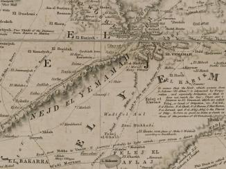
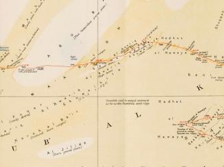
This file concerns a request, made by the Army Headquarters, India, to the British Embassy at Baghdad, for a map of Arabia showing the national and provincial boundaries of Saudi Arabia. The correspondence discusses the difficulties associated with marking out the various boundaries, owing to the fact that many of them are 'the subject of actual or potential controversy'. Also discussed are recommended revisions to the boundaries of Arabia, as shown on a National Geographic Society map of Asia (map not included).
Notable correspondents include the following: His Majesty's Minister at Jedda (Sir Andrew Ryan); officials of the Foreign Office, the India Office The department of the British Government to which the Government of India reported between 1858 and 1947. The successor to the Court of Directors. , the Persian Gulf The historical term used to describe the body of water between the Arabian Peninsula and Iran. Political Residency An office of the East India Company and, later, of the British Raj, established in the provinces and regions considered part of, or under the influence of, British India. , the British Embassy in Baghdad, and the British Library of Information in New York.
In addition to correspondence the file includes the following:
- A copy of a memorandum dated 18 April 1932, which recounts an interdepartmental conference held at the Colonial Office three days earlier, concerning the submission of the frontiers of the mandated territories (namely the Iraq- Transjordan Used in three contexts: the geographical region to the east of the River Jordan (literally ‘across the River Jordan’); a British protectorate (1921-46); an independent political entity (1946-49) now known as Jordan frontier, the Iraq-Kuwait frontier, and the Palestine-Syria frontier) for approval to the Council of the League of Nations.
- Two maps: one depicting the Arabian Peninsula and the other showing the eastern portion of the Aden Protectorate.
Whilst the date range of the file is 1916-1934, only two items (including the aforementioned memorandum) date from earlier than 1934.
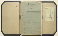
The file includes a divider which gives a list of correspondence references contained in the file by year. This is placed at the back of the correspondence (folio 2).
- Extent and format
- 1 file (59 folios)
- It is grouped into
- 2 imagesRef: IOR/L/PS/12/2129, f 592 imagesRef: IOR/L/PS/12/2129, f 60
- Arrangement
The papers are arranged in approximate chronological order from the rear to the front of the file.
- Physical characteristics
Foliation: the foliation sequence (used for referencing) commences at the inside front cover with 1, and terminates at the last folio with 60; these numbers are written in pencil, are circled, and are located in the top right corner of the recto The front of a sheet of paper or leaf, often abbreviated to 'r'. side of each folio. A previous foliation sequence, which is also circled, has been superseded and therefore crossed out.
- Written in
- English in Latin script
- Type
- Archival file
Archive information for this record
- Original held at
- British Library: India Office The department of the British Government to which the Government of India reported between 1858 and 1947. The successor to the Court of Directors. Records and Private Papers Documents collected in a private capacity.
- Access conditions
Unrestricted
- Archive reference
- IOR/L/PS/12/2129
- Former external reference(s)
- Coll 6/62
- Date(s)
- Sep 1916-14 Dec 1934 (CE, Gregorian)
Access & Reference
History of this record
Related search terms
Use and share this record
- Share this record
- Cite this record in your research
Coll 6/62 'Saudi-Arabia: National and provincial boundaries of –', British Library: India Office Records and Private Papers, IOR/L/PS/12/2129, in Qatar Digital Library <https://www.qdl.qa/archive/81055/vdc_100000000555.0x00029b> [accessed 1 April 2025]
- Link to this record
https://www.qdl.qa/en/archive/81055/vdc_100000000555.0x00029b
- IIIF details
This record has a IIIF manifest available as follows. If you have a compatible viewer you can drag the icon to load it.https://www.qdl.qa/en/iiif/81055/vdc_100000000555.0x00029b/manifestOpen in Universal viewerOpen in Mirador viewerMore options for embedding images
Copyright: How to use this content
- Reference
- IOR/L/PS/12/2129, f 60
- Title
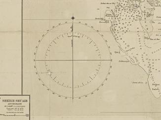
- 'ADEN PROTECTORATE (EASTERN PORTION)'
- Pages
- 60r:60v
- Author
- Lock, A H
- Usage terms
- Public Domain
- Reference
- IOR/L/PS/12/2129
- Title
- Coll 6/62 'Saudi-Arabia: National and provincial boundaries of –'
- Pages
- front, front-i, 2r:58v, back
- Author
- East India Company, the Board of Control, the India Office, or other British Government Department
- Usage terms
- Open Government Licence
- Reference
- IOR/L/PS/12/2129, f 59
- Title
- 'MAP OF ARABIA'
- Pages
- 59r:59v
- Author
- East India Company, the Board of Control, the India Office, or other British Government Department
- Usage terms
- Open Government Licence