A New Map of Arabia: Divided into Its Several Regions and Districts
12891
1 items in this record
The record is made up of 1 items. It was created in 1794. It was written in English. The original is part of the Qatar National Library.
About this record
- Content
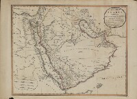
This map of Arabia, published in London in 1794, is an English translation of a map by the French cartographer and geographer Jean-Baptiste Bourguignon d’Anville (1697−1782). Appointed the first geographer to the king of France in 1773, d’Anville was one of the most important mapmakers of the 18th century, known for the accuracy and scientific quality of his maps. The work presented here is said to contain “Additions and Improvements from Mr. Niebuhr,” a reference to Carsten Niebuhr (1733–1815), a German-born Danish explorer and civil engineer who journeyed through Arabia and Yemen in 1762–67 and whose Travels through Arabia and Other Countries in the East (an abridged translation from the original German) was published in Edinburgh in 1792. The map includes cities and towns, coastlines, caravan routes to Mecca, wells, mines, and other geographic features, and brief notations on some of the peoples and kingdoms of the Arabian Peninsula. Qatar is shown as “Catura,” with the notation “Coast little Known” just south of its location. Four distance scales are given: great Arabian miles, great parasangs or Persian leagues, sea leagues, and British miles. The map was published by the London firm of Laurie & Whittle, a partnership of the engraver Robert Laurie (circa 1755−1836) and print seller James Whittle (1757−1818) that was known for its accurate maps and nautical charts.
- Extent and format
- 1 items
- Physical characteristics
1 map ; 46.5 x 59 centimeters
- Written in
- English in Latin script
- Type
- Map
Archive information for this record
- Original held at
- Qatar National Library
- Access conditions
Unrestricted
- Archive reference
- 12891
- Date(s)
- 1794 (CE, Gregorian)
Access & Reference
History of this record
Related search terms
Use and share this record
- Share this record
- Cite this record in your research
A New Map of Arabia: Divided into Its Several Regions and Districts, Qatar National Library, 12891, in Qatar Digital Library <https://www.qdl.qa/archive/qnlhc/12891> [accessed 6 October 2024]
- Link to this record
https://www.qdl.qa/en/archive/qnlhc/12891
- IIIF details
This record has a IIIF manifest available as follows. If you have a compatible viewer you can drag the icon to load it.https://www.qdl.qa/en/iiif/qnlhc/12891/manifestOpen in Universal viewerOpen in Mirador viewerMore options for embedding images
Copyright: How to use this content
- Reference
- 12891
- Title
- A New Map of Arabia: Divided into Its Several Regions and Districts
- Pages
- F-1-1 - F-1-1
- Author
- Qatar National Library
- Usage terms
- Public Domain