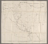
‘‘Iraq-Persia Map No. 1’
IOR/L/PS/20/C204, f 32
2 items in this record
Search within this record
The record is made up of 1 map sheet. It was created in 1926. It was written in English. The original is part of the British Library: India Office The department of the British Government to which the Government of India reported between 1858 and 1947. The successor to the Court of Directors. Records and Private Papers Documents collected in a private capacity. .
About this record
- Content
The map sheet is one of four maps numbered 1 to 4 included in IOR/L/PS/20/C204. In the body of the report it is entitled ‘General Map of Iraq’.
In addition to Iraq the map shows Kuwait, eastern Persia [Iran], and the border areas of Turkey, Syria, and modern-day Saudi Arabia.
The map portrays: the routes of rivers; the southern coast of the Caspian Sea; notable settlements; and railway routes.
Imprint ‘War Office, May, 1926’.
- Extent and format
- 1 map sheet
- Area map covers
- Map loading...
- Scale
- Scale 1:2,000,000
- Scale designator
- Horizontal
- Orientation
- North
- It is part of
- 76 imagesRef: IOR/L/PS/20/C204
- Physical characteristics
Materials: printed on paper
Dimensions: 670 x 585mm, on sheet 710 x 660mm
- Written in
- English in Latin script
- Type
- Map
Archive information for this record
- Original held at
- British Library: India Office The department of the British Government to which the Government of India reported between 1858 and 1947. The successor to the Court of Directors. Records and Private Papers Documents collected in a private capacity.
- Access conditions
Unrestricted
- Archive reference
- IOR/L/PS/20/C204, f 32
- Date(s)
- 1926 (CE, Gregorian)
Access & Reference
History of this record
Related search terms
- Subjects
- Frontiers
- Places
- Kuwait
- People & organisations
- War Office
Use and share this record
- Share this record
- Cite this record in your research
‘‘Iraq-Persia Map No. 1’, British Library: India Office Records and Private Papers, IOR/L/PS/20/C204, f 32, in Qatar Digital Library <https://www.qdl.qa/archive/81055/vdc_100159552838.0x000004> [accessed 31 July 2026]
- Link to this record
https://www.qdl.qa/en/archive/81055/vdc_100159552838.0x000004
- IIIF details
This record has a IIIF manifest available as follows. If you have a compatible viewer you can drag the icon to load it.https://www.qdl.qa/en/iiif/81055/vdc_100000000884.0x0001ab/manifestOpen in Universal viewerOpen in Mirador viewerMore options for embedding images
Copyright: How to use this content
- Reference
- IOR/L/PS/20/C204, f 32
- Title
- ‘‘Iraq-Persia Map No. 1’
- Pages
- 32r:32v
- Author
- East India Company, the Board of Control, the India Office, or other British Government Department
- Usage terms
- Public Domain