‘Map No. 3’
IOR/L/PS/20/C204, f 34


2 items in this record
Search within this record
The record is made up of 1 map sheet. It was created in 1927. It was written in English. The original is part of the British Library: India Office The department of the British Government to which the Government of India reported between 1858 and 1947. The successor to the Court of Directors. Records and Private Papers Documents collected in a private capacity. .
About this record
- Content
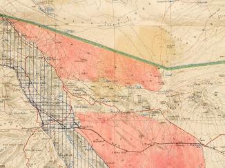
The map sheet is one of four maps, numbered 1 to 4, included in IOR/L/PS/20/C204. In the body of the report it is entitled ‘Mosul Area’.
It shows the boundaries of northern Iraq, centred on the area around the city of Mosul, and including the western border of Persia [Iran], southern border of Turkey, and eastern border of Syria. The double dotted line shows the boundary between Iraq and Syria; the dashed line shows the boundary between Turkey and Syria; the single dotted line shows the boundary between Iraq and Persia; and the thick black line shows the ‘Brussels Boundary’, the border between Iraq and Turkey agreed under League of Nations supervision by the Turkish, Iraqi, and British governments.
The map portrays: the course of rivers, including islands located in the rivers; key geological landmarks such as passes; roads; and tracks.
Imprint ‘Drawn and Printed at the War Office April, 1927’.
- Extent and format
- 1 map sheet
- Area map covers
- Map loading...
- Scale
- Scale 1:506,880
- Scale designator
- Horizontal
- Orientation
- North
- It is part of
- 76 imagesRef: IOR/L/PS/20/C204
- Physical characteristics
Materials: printed on paper
Dimensions: 631 x 450mm, on sheet 680 x 531mm
- Written in
- English in Latin script
- Type
- Map
Archive information for this record
- Original held at
- British Library: India Office The department of the British Government to which the Government of India reported between 1858 and 1947. The successor to the Court of Directors. Records and Private Papers Documents collected in a private capacity.
- Access conditions
Unrestricted
- Archive reference
- IOR/L/PS/20/C204, f 34
- Date(s)
- 1927 (CE, Gregorian)
Access & Reference
History of this record
Related search terms
- Subjects
- Frontiers
- People & organisations
- War Office
Use and share this record
- Share this record
- Cite this record in your research
‘Map No. 3’, British Library: India Office Records and Private Papers, IOR/L/PS/20/C204, f 34, in Qatar Digital Library <https://www.qdl.qa/node/9636> [accessed 17 June 2026]
- Link to this record
https://www.qdl.qa/en/archive/81055/vdc_100159552838.0x000002
- IIIF details
This record has a IIIF manifest available as follows. If you have a compatible viewer you can drag the icon to load it.https://www.qdl.qa/en/iiif/81055/vdc_100000000884.0x0001ab/manifestOpen in Universal viewerOpen in Mirador viewerMore options for embedding images
Copyright: How to use this content
- Reference
- IOR/L/PS/20/C204, f 34
- Title
- ‘Map No. 3’
- Pages
- 34r:34v
- Author
- East India Company, the Board of Control, the India Office, or other British Government Department
- Usage terms
- Public Domain