‘Map illustrating arbitral opinion on Seistan Boundary (General Goldsmid’s report 46, august 1872)’
IOR/L/PS/5/271, f 750

2 items in this record
Search within this record
The record is made up of 1 map sheet. It was created in 1872. It was written in English. The original is part of the British Library: India Office The department of the British Government to which the Government of India reported between 1858 and 1947. The successor to the Court of Directors. Records and Private Papers Documents collected in a private capacity. .
About this record
- Content
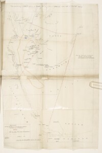
A map illustrating the frontier laid down by arbitrator, the frontier claimed by Persian Commissioner, and the frontier claimed by the Afghan Commissioner. The map is part of a report prepared by Major-General Frederic John Goldsmid and sent to the Secretary to the Government of India, Foreign Department.
The scale is stated as follows: '16 statute miles equal one inch'.
- Extent and format
- 1 map sheet
- It is part of
- 1978 imagesRef: IOR/L/PS/5/271
- Physical characteristics
Materials: coloured and black ink on paper
Dimensions: 610 x 428mm, on sheet 686 x 455mm.
- Written in
- English in Latin script
- Type
- Map
Archive information for this record
- Original held at
- British Library: India Office The department of the British Government to which the Government of India reported between 1858 and 1947. The successor to the Court of Directors. Records and Private Papers Documents collected in a private capacity.
- Access conditions
Unrestricted
- Archive reference
- IOR/L/PS/5/271, f 750
- Date(s)
- 1872 (CE, Gregorian)
Access & Reference
History of this record
Use and share this record
- Share this record
- Cite this record in your research
‘Map illustrating arbitral opinion on Seistan Boundary (General Goldsmid’s report 46, august 1872)’, British Library: India Office Records and Private Papers, IOR/L/PS/5/271, f 750, in Qatar Digital Library <https://www.qdl.qa/archive/81055/vdc_100146659252.0x000002> [accessed 17 July 2024]
- Link to this record
https://www.qdl.qa/en/archive/81055/vdc_100146659252.0x000002
- IIIF details
This record has a IIIF manifest available as follows. If you have a compatible viewer you can drag the icon to load it.https://www.qdl.qa/en/iiif/81055/vdc_100000000319.0x000056/manifestOpen in Universal viewerOpen in Mirador viewerMore options for embedding images
Copyright: How to use this content
- Reference
- IOR/L/PS/5/271, f 750
- Title
- ‘Map illustrating arbitral opinion on Seistan Boundary (General Goldsmid’s report 46, august 1872)’
- Pages
- 750r:750v
- Author
- East India Company, the Board of Control, the India Office, or other British Government Department
- Usage terms
- Open Government Licence