!['Transactions of the Bombay Geographical Society, from January 1847 to May 1849. Edited by the Secretary. Volume VIII.' [‎134] (243/496)](https://iiif.qdl.qa/iiif/images/81055/vdc_100085203449.0x000001/ST 393_ vol 8_0243.jp2/full/!1200,1200/0/default.jpg "'Transactions of the Bombay Geographical Society, from January 1847 to May 1849. Edited by the Secretary. Volume VIII.' [‎134] (243/496)")
'Transactions of the Bombay Geographical Society, from January 1847 to May 1849. Edited by the Secretary. Volume VIII.' [134] (243/496)
The record is made up of 1 volume (466 pages). It was created in 1847-1849. It was written in English. The original is part of the British Library: India Office The department of the British Government to which the Government of India reported between 1858 and 1947. The successor to the Court of Directors. Records and Private Papers Documents collected in a private capacity. .
Transcription
This transcription is created automatically. It may contain errors.
131
3 d. Lieut Ander
son’s journey in 1842.
Major Wilson also informed Sir J, Malcolm, that, from his enquiries, and from
tl ie meteorological observations he made whilst lie was at Mundleysir, it appeared
that the wind blew at this time of the year almost always from the West, increasing
with the Monsoon, and enabling boats, when the current was at its height, to
stem it, and to go in two or three, and sometimes in one day from Chiculdah to
Muheysir,
He stated, that the river between Hirun Pliall and Mundleysir was almost
straight, and that this was a great advantage to the flat-bottomed boats, as they
never had to shift sail in coming up. In going down, they were aided by the
current, and resorted to punting where that was slack and the water shallow.
Lieutenant J. Anderson, of the 17th Regiment Bombay N. I., was appointed
to survey the Nerbudda between Hindea and Hirun Phall in
October 1841, but owing to the non-arrival of the necessary
instruments, he was prevented from making any regular
survey. When ordered to join his Regiment at Bombay, he resolved to proceed
via Baroche in a canoe, “ hoping to contribute somewhat to the scanty information
already possessed regarding the very difficult portion of the river between Hirun
Phall and Soolpan. ,?
The following extract from his report gives the result of his observations as
far down as Tuliuckwara, with an account of the measures lie was compelled to
adopt when stopped in his further progress at the mouth of the Hutnee river: —
<c I left Mundleysir on the morning of the 21st March 1842, in one of the
ordinary passage boats used at the ferry: halted for the night at Kuttora, and
arrived at Chiculdah on the evening of the 22d at sunset.
i( This portion of the river, fifty-one miles in length, is navigable by boats
lightly laden until nearly the end of the dry weather, with the exception of the
rapids called Sahesur Durrah, which are about two miles below the town of
Mub ey sir.
“ This is rather a formidable obstruction, consisting of a belt of rock stretching
diagonally across the river, and intersected by a great many narrow and tortuous
channels, through which the water rushes with great impetuosity, until it is
finally precipitated over a shelf about eight or ten feet in height into a sort oi
trough, at the extremity of which it again becomes navigable. Luckily, however,
there is a back stream near the Southern bank, which affords a rather dilhcu
passage for unladen boats until within about a month of the rains, but nug 1
easily be made practicable throughout the year by means hereafter explained.
“ Between this and Chiculdah there are a few shallows and rapids, but I ob
served no obstacle particularly worthy of notice, and have no doubt that a com
paratively trifling outlay would render this portion of the river available for boa^
much larger than that 1 sailed in for nearly, if not quite, the whole of the y ea 1
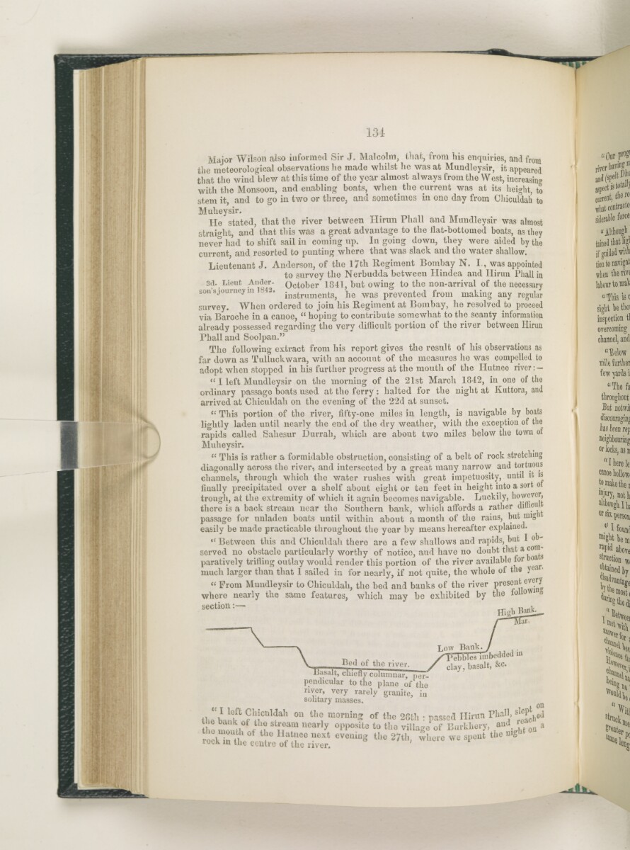
“ From Mundleysir to Chiculdah, the bed and banks of the river present evei y
where nearly the same features, which may be exhibited by the folio' a
section:—
Hi ah Bank
far.
\
\
V Bed of the river.
Basalt, chiefly columnar"
Low Bank. .
"bbles imbedded m
clay, basalt, &c.
pendicular to the plane of ^the
granite, in
on
river, very rarely
solitary masses.
tl p 1 ? 1 icuI f ah 011 ll1 ® mornin 2 of the 28th : passed Hirun Phall,
t o mo l f 1? st ™ am uearl y 0 PP°site to the village of Burkhery, and ^
rock n u 1 ° f 10 Hat f e next evellio £ the 27th, where we spent the
rock m the centre of the river.
ach<
on
About this item
- Content
Transactions of the Bombay Geographical Society, from January 1847 to May 1849. Edited by the Secretary. Volume VIII.
Publication details: Bombay: Printed at The Times' Press, by James Chesson, 1849.
- Extent and format
- 1 volume (466 pages)
- Arrangement
This volume contains a table of contents giving headings and page references. There is an index to Volumes I-XVII (1836-1864) in a separate volume (ST 393, index).
- Physical characteristics
Dimensions: 220 x 140mm
- Written in
- English in Latin script View the complete information for this record
Use and share this item
- Share this item
'Transactions of the Bombay Geographical Society, from January 1847 to May 1849. Edited by the Secretary. Volume VIII.' [134] (243/496), British Library: India Office Records and Private Papers, ST 393, vol 8, in Qatar Digital Library <https://www.qdl.qa/archive/81055/vdc_100099762283.0x00002c> [accessed 2 August 2026]
https://www.qdl.qa/en/archive/81055/vdc_100099762283.0x00002c
Copy and paste the code below into your web page where you would like to embed the image.
<meta charset="utf-8"><a href="https://www.qdl.qa/en/archive/81055/vdc_100099762283.0x00002c">'Transactions of the Bombay Geographical Society, from January 1847 to May 1849. Edited by the Secretary. Volume VIII.' [‎134] (243/496)</a> <a href="https://www.qdl.qa/en/archive/81055/vdc_100099762283.0x00002c"> <img src="https://iiif.qdl.qa/iiif/images/81055/vdc_100085203449.0x000001/ST 393_ vol 8_0243.jp2/full/!280,240/0/default.jpg" alt="" /> </a>
This record has a IIIF manifest available as follows. If you have a compatible viewer you can drag the icon to load it.https://www.qdl.qa/en/iiif/81055/vdc_100085203449.0x000001/manifestOpen in Universal viewerOpen in Mirador viewerMore options for embedding images
Copyright: How to use this content
- Reference
- ST 393, vol 8
- Title
- 'Transactions of the Bombay Geographical Society, from January 1847 to May 1849. Edited by the Secretary. Volume VIII.'
- Pages
- front, back, spine, edge, head, tail, front-i, i-r:ii-v, 1:4, 1:51, 51a, 52:85, 1:10, 10a, 10a, 11:92, 92a, 92a:92b, 92b:92c, 92c, 93:382, iii-r:iv-v, back-i
- Author
- Bombay Geographical Society
- Usage terms
- Public Domain