'The Transactions of the Bombay Geographical Society. From January 1863 to December 1864. (Edited by the Secretary.) Volume XVII.'
ST 393, vol 17


524 items in this record
Search within this record
The record is made up of 1 volume (451 pages). It was created in 1863-1864. It was written in English. The original is part of the British Library: India Office The department of the British Government to which the Government of India reported between 1858 and 1947. The successor to the Court of Directors. Records and Private Papers Documents collected in a private capacity. .
About this record
- Content
The Transactions of the Bombay Geographical Society. From January 1863 to December 1864. (Edited by the Secretary.) Volume XVII.
Publication details: Bombay: Printed at the Education Society's Press, Byculla, 1865.
With maps, etc.
- Extent and format
- 1 volume (451 pages)
- It is grouped into
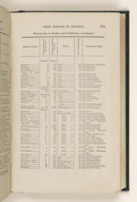
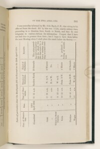
- 2 imagesRef: ST 393, vol 17, p 32a2 imagesRef: ST 393, vol 17, p 116a2 imagesRef: ST 393, vol 17, p 140a2 imagesRef: ST 393, vol 17, p 166a2 imagesRef: ST 393, vol 17, p 236a2 imagesRef: ST 393, vol 17, p 302a
- Arrangement
This volume contains a table of contents giving headings and page references, and two indexes. There is an index to Volumes I-XVII (1836-1864) in a separate volume (ST 393, index).
- Physical characteristics
Dimensions: 220 x 140mm
- Written in
- English in Latin script
- Type
- Archival file
Archive information for this record
- Original held at
- British Library: India Office The department of the British Government to which the Government of India reported between 1858 and 1947. The successor to the Court of Directors. Records and Private Papers Documents collected in a private capacity.
- Access conditions
Unrestricted
- Archive reference
- ST 393, vol 17
- Date(s)
- 1863-1864 (CE, Gregorian)
Access & Reference
History of this record
Use and share this record
- Share this record
- Cite this record in your research
'The Transactions of the Bombay Geographical Society. From January 1863 to December 1864. (Edited by the Secretary.) Volume XVII.', British Library: India Office Records and Private Papers, ST 393, vol 17, in Qatar Digital Library <https://www.qdl.qa/archive/81055/vdc_100085203917.0x000001> [accessed 4 June 2026]
- Link to this record
https://www.qdl.qa/en/archive/81055/vdc_100085203917.0x000001
- IIIF details
This record has a IIIF manifest available as follows. If you have a compatible viewer you can drag the icon to load it.https://www.qdl.qa/en/iiif/81055/vdc_100085203917.0x000001/manifestOpen in Universal viewerOpen in Mirador viewerMore options for embedding images
Copyright: How to use this content
- Reference
- ST 393, vol 17
- Title
- 'The Transactions of the Bombay Geographical Society. From January 1863 to December 1864. (Edited by the Secretary.) Volume XVII.'
- Pages
- front, back, spine, edge, head, tail, front-i, i-r:ii-v, 1, 1a:1b, 2:16, 1:132, 1:18, 18a:18b, 19:206, 206a:206b, 207:256, 256a:256b, 257:340, iii-r:iv-v, back-i
- Author
- Bombay Geographical Society
- Usage terms
- Public Domain
- Reference
- ST 393, vol 17, p 32a
- Title
- 'SKETCH of the GULF OF PERSIA. Showing the seven Classes of Jurisdiction enumerated in my letter No. 67 of 13th. April 1863.'
- Pages
- 32a:32b
- Author
- Bombay Geographical Society
- Usage terms
- Public Domain
- Reference
- ST 393, vol 17, p 116a
- Title
- 'GULF OF PERSIA. Showing our route from Bussorah to Koweit, and thence by Zobaire, Mahommerah, and the Country of the Chaab Arabs to Bushire.'
- Pages
- 116a:116b
- Author
- Bombay Geographical Society
- Usage terms
- Public Domain
- Reference
- ST 393, vol 17, p 140a
- Title
- 'BUSHIRE to SHIRAUZ and PERSEPOLIS.'
- Pages
- 140a:140b
- Author
- Bombay Geographical Society
- Usage terms
- Public Domain
- Reference
- ST 393, vol 17, p 166a
- Title
- 'GEOLOGICAL Sketch Map of the TURKO-PERSIAN FRONTIER, by W. K. LOFTUS, F.G.S.'
- Pages
- 166a:166b
- Author
- Bombay Geographical Society
- Usage terms
- Public Domain
- Reference
- ST 393, vol 17, p 236a
- Title
- 'TRACING SHOWING THE ROUTE AND COAST LINE FROM MOGOO BAY TO THE TOWN OF BUNDER ABBAS. (VIDE REPORT NO. 6 OF 1864)'
- Pages
- 236a:236b
- Author
- Bombay Geographical Society
- Usage terms
- Public Domain
- Reference
- ST 393, vol 17, p 302a
- Title
- 'ROUGH SKETCH PLAN of the DHAR YARO PLATEAU on the Summit of the KEERTHUR RIDGE of the HALA RANGE, LARKHANA DISTRICT, SIND.'
- Pages
- 302a:302b
- Author
- Bombay Geographical Society
- Usage terms
- Public Domain