‘SKETCH MAP OF BAIT AL FALAJ AREA’
IOR/R/15/6/99, ff 148-149


7 items in this record
Search within this record
The record is made up of 1 map. It was created in 1939. It was written in English. The original is part of the British Library: India Office The department of the British Government to which the Government of India reported between 1858 and 1947. The successor to the Court of Directors. Records and Private Papers Documents collected in a private capacity. .
About this record
- Content
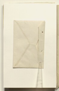
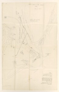
A sketch map of Bait Al-Falaj landing ground with an envelope. The map shows the proposed concrete runways in dotted lines. The map is drawn by the Air Liaison Officer at Muscat and it is part of a letter (ff 3-4) sent to the Air Headquarters, British Forces in Iraq.
- Extent and format
- 1 map
- Area map covers
- Map loading...
- Orientation
- North
- Projection
- vertical
- Degree coordinates
- Top-left: 23° 36' 55.29" N, 58° 32' 1.52" E
Top-right: 23° 36' 55.29" N, 58° 32' 49.1" E
Bottom-left: 23° 35' 43.23" N, 58° 32' 1.52" E
Bottom-right: 23° 35' 43.23" N, 58° 32' 49.1" E - It is part of
- 307 imagesRef: IOR/R/15/6/99
- Physical characteristics
Materials: manuscript ink and pencil on tissue paper.
Dimensions: 687 x 432mm.
- Written in
- English in Latin script
- Type
- Map
Archive information for this record
- Original held at
- British Library: India Office The department of the British Government to which the Government of India reported between 1858 and 1947. The successor to the Court of Directors. Records and Private Papers Documents collected in a private capacity.
- Access conditions
Unrestricted
- Archive reference
- IOR/R/15/6/99, ff 148-149
- Date(s)
- 1939 (CE, Gregorian)
Access & Reference
History of this record
Use and share this record
- Share this record
- Cite this record in your research
‘SKETCH MAP OF BAIT AL FALAJ AREA’, British Library: India Office Records and Private Papers, IOR/R/15/6/99, ff 148-149, in Qatar Digital Library <https://www.qdl.qa/archive/81055/vdc_100076686717.0x000001> [accessed 15 February 2025]
- Link to this record
https://www.qdl.qa/en/archive/81055/vdc_100076686717.0x000001
- IIIF details
This record has a IIIF manifest available as follows. If you have a compatible viewer you can drag the icon to load it.https://www.qdl.qa/en/iiif/81055/vdc_100000000831.0x0002eb/manifestOpen in Universal viewerOpen in Mirador viewerMore options for embedding images
Copyright: How to use this content
- Reference
- IOR/R/15/6/99, ff 148-149
- Title
- ‘SKETCH MAP OF BAIT AL FALAJ AREA’
- Pages
- 148r:148v, 148v:149r, 149r:149v, 149v
- Author
- East India Company, the Board of Control, the India Office, or other British Government Department
- Usage terms
- Public Domain