!['Map of Arabia and the Persian Gulf' [‎28r] (1/2)](https://iiif.qdl.qa/iiif/images/81055/vdc_100000000419.0x000231/IOR_L_PS_10_666_0061.jp2/full/!1200,1200/0/default.jpg "'Map of Arabia and the Persian Gulf' [‎28r] (1/2)")
'Map of Arabia and the Persian Gulf' [28r] (1/2)
The record is made up of 1 map. It was created in 1916. It was written in English. The original is part of the British Library: India Office The department of the British Government to which the Government of India reported between 1858 and 1947. The successor to the Court of Directors. Records and Private Papers Documents collected in a private capacity. .
About this item
- Content
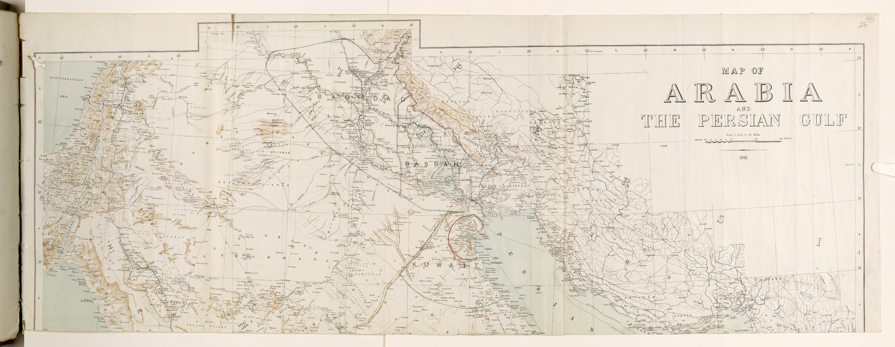
Part of a map, of which the bottom half is missing. It shows the territories of Arabia and the Persian Gulf The historical term used to describe the body of water between the Arabian Peninsula and Iran. , with the borders of Baghdad, Basra and Kuwait printed in blue, and in green. More information regarding the map is given in War Office correspondence at folio 13.
- Extent and format
- 1 map
- Area map covers
- Map loading...
- Scale
- 1:182.880
- Scale designator
- Horizontal
- Orientation
- North
- Degree coordinates
- Top-left: 35° 10' 12" N, 34° 55' 12" E
Top-right: 35° 10' 12" N, 50° 16' 48" E
Bottom-left: 27° 38' 24" N, 34° 55' 12" E
Bottom-right: 27° 38' 24" N, 50° 16' 48" E - Physical characteristics
Material: Printed on paper
Dimensions: 332 x 875mm
- Written in
- English in Latin script View the complete information for this record
Use and share this item
- Share this item
'Map of Arabia and the Persian Gulf' [28r] (1/2), British Library: India Office Records and Private Papers, IOR/L/PS/10/666, f 28, in Qatar Digital Library <https://www.qdl.qa/archive/81055/vdc_100075826204.0x00003d> [accessed 11 March 2025]
https://www.qdl.qa/en/archive/81055/vdc_100075826204.0x00003d
Copy and paste the code below into your web page where you would like to embed the image.
<meta charset="utf-8"><a href="https://www.qdl.qa/en/archive/81055/vdc_100075826204.0x00003d">'Map of Arabia and the Persian Gulf' [‎28r] (1/2)</a> <a href="https://www.qdl.qa/en/archive/81055/vdc_100075826204.0x00003d"> <img src="https://iiif.qdl.qa/iiif/images/81055/vdc_100000000419.0x000231/IOR_L_PS_10_666_0061.jp2/full/!280,240/0/default.jpg" alt="" /> </a>
This record has a IIIF manifest available as follows. If you have a compatible viewer you can drag the icon to load it.https://www.qdl.qa/en/iiif/81055/vdc_100000000419.0x000231/manifestOpen in Universal viewerOpen in Mirador viewerMore options for embedding images
Copyright: How to use this content
- Reference
- IOR/L/PS/10/666, f 28
- Title
- 'Map of Arabia and the Persian Gulf'
- Pages
- 28r:28v
- Author
- Unknown
- Usage terms
- The copyright status is unknown. Please contact [email protected] with any information you have regarding this item.