![‘Sketch Map of the Mouth of the Shatt-El-Arab’ [‎32r] (1/2)](https://iiif.qdl.qa/iiif/images/81055/vdc_100000001452.0x0003c4/Mss Eur F111_360_0067.jp2/full/!1200,1200/0/default.jpg "‘Sketch Map of the Mouth of the Shatt-El-Arab’ [‎32r] (1/2)")
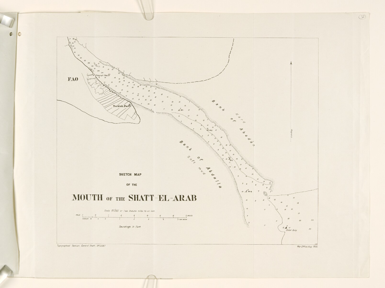
‘Sketch Map of the Mouth of the Shatt-El-Arab’ [32r] (1/2)
The record is made up of 1 map. It was created in Aug 1905. It was written in English. The original is part of the British Library: India Office The department of the British Government to which the Government of India reported between 1858 and 1947. The successor to the Court of Directors. Records and Private Papers Documents collected in a private capacity. .
About this item
- Content
The map depicts the mouth of the Shatt El Arab waterway with soundings Measurements of the depth of a body of water. in feet. It includes a diagram of the settlement of Fao, the location of the 'Turkish Fort', and the telegraph station.
The scale is stated as 1/97,280 or 1.535 statute miles to the inch. An arrow indicates magnetic north.
The map was prepared by the Topographical Section, General Staff of the War Office in 1905.
- Extent and format
- 1 map
- Area map covers
- Map loading...
- Orientation
- North
- Degree coordinates
- Top-left: 30° 14' 24" N, 47° 45' 36" E
Top-right: 30° 14' 24" N, 48° 29' 24" E
Bottom-left: 29° 30' 0" N, 47° 45' 36" E
Bottom-right: 29° 30' 0" N, 48° 29' 24" E - Physical characteristics
Materials: Printed on paper
Dimensions: 340 x 450mm
- Written in
- English in Latin script View the complete information for this record
Use and share this item
- Share this item
‘Sketch Map of the Mouth of the Shatt-El-Arab’ [32r] (1/2), British Library: India Office Records and Private Papers, Mss Eur F111/360, f 32, in Qatar Digital Library <https://www.qdl.qa/archive/81055/vdc_100074887171.0x000040> [accessed 7 February 2025]
https://www.qdl.qa/en/archive/81055/vdc_100074887171.0x000040
Copy and paste the code below into your web page where you would like to embed the image.
<meta charset="utf-8"><a href="https://www.qdl.qa/en/archive/81055/vdc_100074887171.0x000040">‘Sketch Map of the Mouth of the Shatt-El-Arab’ [‎32r] (1/2)</a> <a href="https://www.qdl.qa/en/archive/81055/vdc_100074887171.0x000040"> <img src="https://iiif.qdl.qa/iiif/images/81055/vdc_100000001452.0x0003c4/Mss Eur F111_360_0067.jp2/full/!280,240/0/default.jpg" alt="" /> </a>
This record has a IIIF manifest available as follows. If you have a compatible viewer you can drag the icon to load it.https://www.qdl.qa/en/iiif/81055/vdc_100000001452.0x0003c4/manifestOpen in Universal viewerOpen in Mirador viewerMore options for embedding images
Copyright: How to use this content
- Reference
- Mss Eur F111/360, f 32
- Title
- ‘Sketch Map of the Mouth of the Shatt-El-Arab’
- Pages
- 32r:32v
- Author
- East India Company, the Board of Control, the India Office, or other British Government Department
- Usage terms
- Open Government Licence