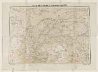
'SKETCH MAP OF CHITRAL AND SURROUNDING COUNTRIES.'
Mss Eur F111/68, f 27
2 items in this record
Search within this record
The record is made up of 1 map. It was created in Jan 1901. It was written in English. The original is part of the British Library: India Office The department of the British Government to which the Government of India reported between 1858 and 1947. The successor to the Court of Directors. Records and Private Papers Documents collected in a private capacity. .
About this record
- Content
Map showing Chitral state to the north of British India, in modern-day Pakistan. The map indicates hydrology and boundaries, as well as providing some indication of relief. Compiled and reproduced by the Intelligence Branch of the Government of India's Quarter Master General Department.
- Extent and format
- 1 map
- Area map covers
- Map loading...
- Scale
- Scale approximately 1:498,900
- Scale designator
- Horizontal
- Orientation
- North
- Degree coordinates
- Top-left: 37° 17' 55.09" N, 70° 21' 47.92" E
Top-right: 37° 17' 55.09" N, 75° 0' 52.73" E
Bottom-left: 35° 0' 59.4" N, 70° 21' 47.92" E
Bottom-right: 35° 0' 59.4" N, 75° 0' 52.73" E - It is part of
- 202 imagesRef: Mss Eur F111/68
- Physical characteristics
Materials: Printed in colour on paper.
Dimensions: 579 x 824mm, on sheet 685 x 960mm.
- Written in
- English in Latin script
- Type
- Map
Archive information for this record
- Original held at
- British Library: India Office The department of the British Government to which the Government of India reported between 1858 and 1947. The successor to the Court of Directors. Records and Private Papers Documents collected in a private capacity.
- Access conditions
Unrestricted
- Archive reference
- Mss Eur F111/68, f 27
- Date(s)
- Jan 1901 (CE, Gregorian)
Access & Reference
History of this record
Related search terms
- Places
- Chitral State
Use and share this record
- Share this record
- Cite this record in your research
'SKETCH MAP OF CHITRAL AND SURROUNDING COUNTRIES.', British Library: India Office Records and Private Papers, Mss Eur F111/68, f 27, in Qatar Digital Library <https://www.qdl.qa/archive/81055/vdc_100070524442.0x000004> [accessed 17 July 2024]
- Link to this record
https://www.qdl.qa/en/archive/81055/vdc_100070524442.0x000004
- IIIF details
This record has a IIIF manifest available as follows. If you have a compatible viewer you can drag the icon to load it.https://www.qdl.qa/en/iiif/81055/vdc_100000001452.0x0002b2/manifestOpen in Universal viewerOpen in Mirador viewerMore options for embedding images
Copyright: How to use this content
- Reference
- Mss Eur F111/68, f 27
- Title
- 'SKETCH MAP OF CHITRAL AND SURROUNDING COUNTRIES.'
- Pages
- 27r:27v
- Author
- East India Company, the Board of Control, the India Office, or other British Government Department
- Usage terms
- Public Domain