![Sketch map of Ras al Khaima area [‎120v] (2/2)](https://iiif.qdl.qa/iiif/images/81055/vdc_100000000193.0x0000fb/IOR_R_15_1_278_0271.jp2/full/!1200,1200/0/default.jpg "Sketch map of Ras al Khaima area [‎120v] (2/2)")
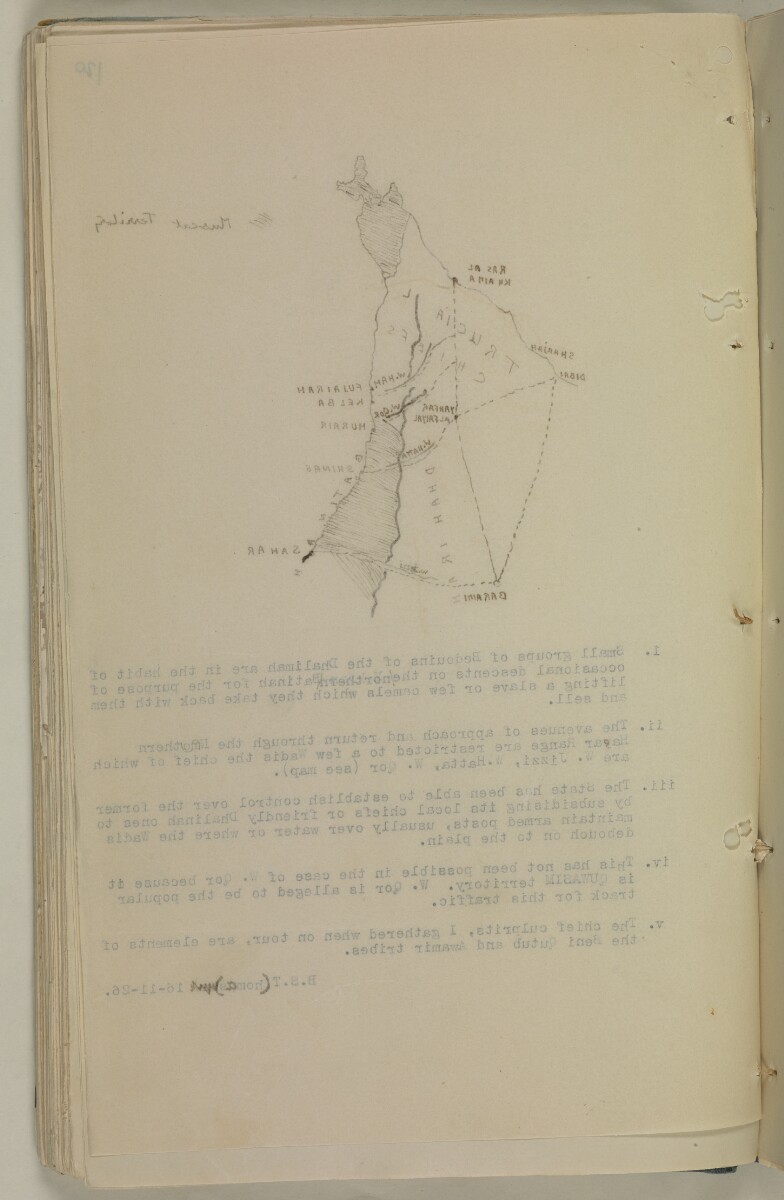
Sketch map of Ras al Khaima area [120v] (2/2)
The record is made up of 1 map. It was created in 1926. It was written in English. The original is part of the British Library: India Office The department of the British Government to which the Government of India reported between 1858 and 1947. The successor to the Court of Directors. Records and Private Papers Documents collected in a private capacity. .
About this item
- Content
Distinctive Features:
Hand-drawn map of tribal territories around Ras al Khaima with ports and valleys labelled, and routes indicated by pecked line. Muscat limits shown by hatched markings.
Below map typed explanatory notes with references to the slave traffic, signed by Bertram S. Thomas and dated ‘16-11-26’.
- Extent and format
- 1 map
- Area map covers
- Map loading...
- Scale
- Scale not given
- Scale designator
- Horizontal
- Orientation
- North
- Degree coordinates
- Top-left: 26° 25' 48" N, 55° 15' 11.88" E
Top-right: 26° 25' 48" N, 56° 59' 16.08" E
Bottom-left: 24° 12' 32.76" N, 55° 15' 11.88" E
Bottom-right: 24° 12' 32.76" N, 56° 59' 16.08" E - Physical characteristics
Materials:
Pen and ink on paper with typed text
Dimensions:
315 x 202 mm
- Written in
- English in Latin script View the complete information for this record
Use and share this item
- Share this item
Sketch map of Ras al Khaima area [120v] (2/2), British Library: India Office Records and Private Papers, IOR/R/15/1/278, f 120, in Qatar Digital Library <https://www.qdl.qa/archive/81055/vdc_100070467083.0x00003a> [accessed 31 March 2025]
https://www.qdl.qa/en/archive/81055/vdc_100070467083.0x00003a
Copy and paste the code below into your web page where you would like to embed the image.
<meta charset="utf-8"><a href="https://www.qdl.qa/en/archive/81055/vdc_100070467083.0x00003a">Sketch map of Ras al Khaima area [‎120v] (2/2)</a> <a href="https://www.qdl.qa/en/archive/81055/vdc_100070467083.0x00003a"> <img src="https://iiif.qdl.qa/iiif/images/81055/vdc_100000000193.0x0000fb/IOR_R_15_1_278_0271.jp2/full/!280,240/0/default.jpg" alt="" /> </a>
This record has a IIIF manifest available as follows. If you have a compatible viewer you can drag the icon to load it.https://www.qdl.qa/en/iiif/81055/vdc_100000000193.0x0000fb/manifestOpen in Universal viewerOpen in Mirador viewerMore options for embedding images
Copyright: How to use this content
- Reference
- IOR/R/15/1/278, f 120
- Title
- Sketch map of Ras al Khaima area
- Pages
- 120r:120v
- Author
- East India Company, the Board of Control, the India Office, or other British Government Department
- Usage terms
- Open Government Licence