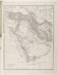
Map of the Arabian Peninsula, With the Hejaz Area Marked in Red
IOR/L/PS/10/616, f 72
2 items in this record
Search within this record
The record is made up of 1 map. It was created in c Oct 1917. It was written in English. The original is part of the British Library: India Office The department of the British Government to which the Government of India reported between 1858 and 1947. The successor to the Court of Directors. Records and Private Papers Documents collected in a private capacity. .
About this record
- Content
The map shows the Arabian Peninsula and the surrounding area, including parts of the Turkish [Ottoman] Empire, Russia, Persia [Iran], Egypt, Nubia, and Abyssinia. The Hejaz area is marked with a red line. The map indicates hydrology, railways, and submarine telegraph lines, and includes some indication of relief. The map bears the printing statement 'Stanford's Geol. Estabt., London'.
The map is referred to on folios 69 to 70 of IOR/L/PS/10/616.
- Extent and format
- 1 map
- Area map covers
- Map loading...
- Scale
- 1:6.969.600
- Scale designator
- Horizontal
- Orientation
- North
- Degree coordinates
- Top-left: 44° 1' 12" N, 32° 4' 48" E
Top-right: 44° 1' 12" N, 60° 1' 48" E
Bottom-left: 8° 1' 12" N, 32° 4' 48" E
Bottom-right: 8° 1' 12" N, 60° 1' 48" E - It is part of
- 498 imagesRef: IOR/L/PS/10/616
- Physical characteristics
Materials: Printed on paper
Dimensions: 483mm x 628mm, on sheet 540mm x 729mm
- Written in
- English in Latin script
- Type
- Map
Archive information for this record
- Original held at
- British Library: India Office The department of the British Government to which the Government of India reported between 1858 and 1947. The successor to the Court of Directors. Records and Private Papers Documents collected in a private capacity.
- Access conditions
Unrestricted
- Archive reference
- IOR/L/PS/10/616, f 72
- Former external reference(s)
- Map A 126
- Date(s)
- c Oct 1917 (CE, Gregorian)
Access & Reference
History of this record
Use and share this record
- Share this record
- Cite this record in your research
Map of the Arabian Peninsula, With the Hejaz Area Marked in Red, British Library: India Office Records and Private Papers, IOR/L/PS/10/616, f 72, in Qatar Digital Library <https://www.qdl.qa/archive/81055/vdc_100048155530.0x000001> [accessed 12 March 2025]
- Link to this record
https://www.qdl.qa/en/archive/81055/vdc_100048155530.0x000001
- IIIF details
This record has a IIIF manifest available as follows. If you have a compatible viewer you can drag the icon to load it.https://www.qdl.qa/en/iiif/81055/vdc_100000000419.0x0001ff/manifestOpen in Universal viewerOpen in Mirador viewerMore options for embedding images
Copyright: How to use this content
- Reference
- IOR/L/PS/10/616, f 72
- Title
- Map of the Arabian Peninsula, With the Hejaz Area Marked in Red
- Pages
- 72r:72v
- Author
- Stanford's Geographical Establishment
- Usage terms
- Public Domain