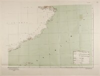
Map of the Arabian Peninsula
IOR/L/PS/12/2160B, f 43
2 items in this record
Search within this record
The record is made up of 1 map on 4 sheets. It was created in Feb 1932. It was written in English. The original is part of the British Library: India Office The department of the British Government to which the Government of India reported between 1858 and 1947. The successor to the Court of Directors. Records and Private Papers Documents collected in a private capacity. .
About this record
- Content
Map depicting the south-eastern tip of the Arabian Peninsula. The map indicates hydrology and settlements, as well as providing some indication of relief in the form of hachures. A table of symbols appears on the map.
Originally published in 1910 by the Surveyor General of India, with additions in 1916. Reprinted with minor additions and corrections by the War Office's Geographical Section, General Staff, in 1930 (this copy is dated February 1932).
- Extent and format
- 1 map on 4 sheets
- Area map covers
- Map loading...
- Scale
- Scale not given
- Scale designator
- Horizontal
- Orientation
- North
- Degree coordinates
- Top-left: 22° 51' 0" N, 50° 38' 24" E
Top-right: 22° 51' 0" N, 66° 29' 24" E
Bottom-left: 12° 0' 0" N, 50° 38' 24" E
Bottom-right: 12° 0' 0" N, 66° 29' 24" E - It is part of
- 133 imagesRef: IOR/L/PS/12/2160B
- Physical characteristics
Materials: Printed in colour on paper.
Dimensions: 656 x 861mm, on sheet 753 x 984mm.
- Written in
- English in Latin script
- Type
- Map
Archive information for this record
- Original held at
- British Library: India Office The department of the British Government to which the Government of India reported between 1858 and 1947. The successor to the Court of Directors. Records and Private Papers Documents collected in a private capacity.
- Access conditions
Unrestricted
- Archive reference
- IOR/L/PS/12/2160B, f 43
- Date(s)
- Feb 1932 (CE, Gregorian)
Access & Reference
History of this record
Use and share this record
- Share this record
- Cite this record in your research
Map of the Arabian Peninsula, British Library: India Office Records and Private Papers, IOR/L/PS/12/2160B, f 43, in Qatar Digital Library <https://www.qdl.qa/archive/81055/vdc_100042760282.0x000004> [accessed 16 February 2025]
- Link to this record
https://www.qdl.qa/en/archive/81055/vdc_100042760282.0x000004
- IIIF details
This record has a IIIF manifest available as follows. If you have a compatible viewer you can drag the icon to load it.https://www.qdl.qa/en/iiif/81055/vdc_100000000555.0x0002bb/manifestOpen in Universal viewerOpen in Mirador viewerMore options for embedding images
Copyright: How to use this content
- Reference
- IOR/L/PS/12/2160B, f 43
- Title
- Map of the Arabian Peninsula
- Pages
- 43r:43v
- Author
- East India Company, the Board of Control, the India Office, or other British Government Department
- Usage terms
- Open Government Licence