![Sketch of the East Saudi Arabian Coast [‎213r] (1/2)](https://iiif.qdl.qa/iiif/images/81055/vdc_100000000555.0x00028d/IOR_L_PS_12_2115_0435.jp2/full/!1200,1200/0/default.jpg "Sketch of the East Saudi Arabian Coast [‎213r] (1/2)")
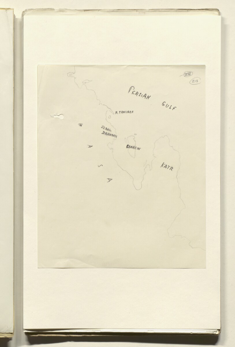
Sketch of the East Saudi Arabian Coast [213r] (1/2)
The record is made up of 1 map. It was created in 1935?. It was written in English. The original is part of the British Library: India Office The department of the British Government to which the Government of India reported between 1858 and 1947. The successor to the Court of Directors. Records and Private Papers Documents collected in a private capacity. .
About this item
- Content
Sketch in pencil and black ink depicting the eastern part of the Arabian Peninsula as well as the Persian Gulf The historical term used to describe the body of water between the Arabian Peninsula and Iran. . Marked in ink are the following: the Hasa [Al Hasa] region of eastern Saudi Arabia, R Tanurah [Ras Tanura], Jebel Dhahran [Jabal Z̧ahrān], Bahrein [Bahrain] and Katr [Qatar]. Elsewhere in the file the map is attributed to Percy Gordon Loch, Acting Political Resident A senior ranking political representative (equivalent to a Consul General) from the diplomatic corps of the Government of India or one of its subordinate provincial governments, in charge of a Political Residency. in the Persian Gulf The historical term used to describe the body of water between the Arabian Peninsula and Iran. .
- Extent and format
- 1 map
- Area map covers
- Map loading...
- Scale
- Scale not given
- Scale designator
- Horizontal
- Orientation
- North
- Degree coordinates
- Top-left: 27° 29' 37.32" N, 49° 2' 24.72" E
Top-right: 27° 29' 37.32" N, 51° 54' 37.44" E
Bottom-left: 24° 11' 48.84" N, 49° 2' 24.72" E
Bottom-right: 24° 11' 48.84" N, 51° 54' 37.44" E - Physical characteristics
Materials: Manuscript; black ink and pencil on paper
Dimensions: 212 x 175mm
- Written in
- English in Latin script View the complete information for this record
Use and share this item
- Share this item
Sketch of the East Saudi Arabian Coast [213r] (1/2), British Library: India Office Records and Private Papers, IOR/L/PS/12/2115, f 213, in Qatar Digital Library <https://www.qdl.qa/archive/81055/vdc_100040749882.0x00001c> [accessed 1 August 2026]
https://www.qdl.qa/en/archive/81055/vdc_100040749882.0x00001c
Copy and paste the code below into your web page where you would like to embed the image.
<meta charset="utf-8"><a href="https://www.qdl.qa/en/archive/81055/vdc_100040749882.0x00001c">Sketch of the East Saudi Arabian Coast [‎213r] (1/2)</a> <a href="https://www.qdl.qa/en/archive/81055/vdc_100040749882.0x00001c"> <img src="https://iiif.qdl.qa/iiif/images/81055/vdc_100000000555.0x00028d/IOR_L_PS_12_2115_0435.jp2/full/!280,240/0/default.jpg" alt="" /> </a>
This record has a IIIF manifest available as follows. If you have a compatible viewer you can drag the icon to load it.https://www.qdl.qa/en/iiif/81055/vdc_100000000555.0x00028d/manifestOpen in Universal viewerOpen in Mirador viewerMore options for embedding images
Copyright: How to use this content
- Reference
- IOR/L/PS/12/2115, f 213
- Title
- Sketch of the East Saudi Arabian Coast
- Pages
- 213r:213v
- Author
- East India Company, the Board of Control, the India Office, or other British Government Department
- Usage terms
- Public Domain