![Sketch Map of South-West Haycock Island [‎119r] (1/2)](https://iiif.qdl.qa/iiif/images/81055/vdc_100000000555.0x000292/IOR_L_PS_12_2120_0240.jp2/full/!1200,1200/0/default.jpg "Sketch Map of South-West Haycock Island [‎119r] (1/2)")
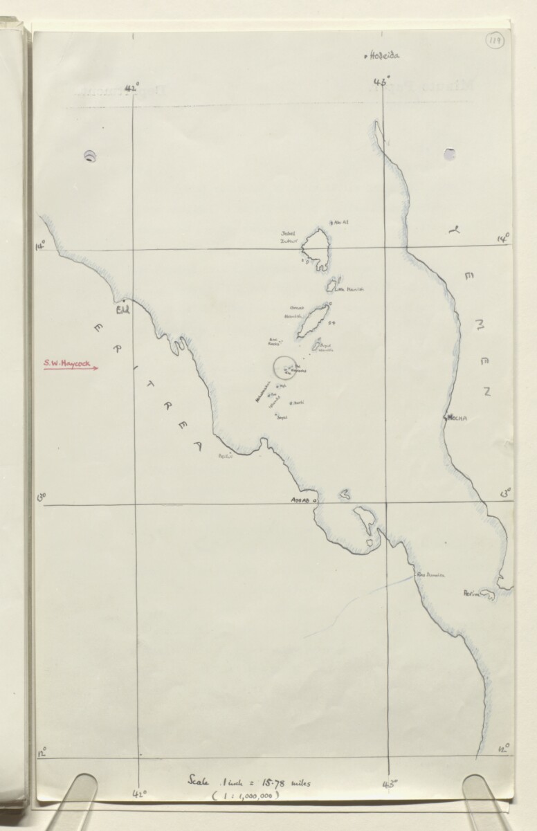
Sketch Map of South-West Haycock Island [119r] (1/2)
The record is made up of 1 map. It was created in 1930?. It was written in English. The original is part of the British Library: India Office The department of the British Government to which the Government of India reported between 1858 and 1947. The successor to the Court of Directors. Records and Private Papers Documents collected in a private capacity. .
About this item
- Content
Sketch map drawn on India Office The department of the British Government to which the Government of India reported between 1858 and 1947. The successor to the Court of Directors. minute paper, depicting South-West Haycock Island, the Hanish Islands, Jebel Zukur Island [Jazīrat Jabal Zuqar], and other islands in the Lower Red Sea. The coasts of Eritrea and Yemen are shown on the west and east side of the Red Sea respectively. South-West Haycock Island is circled in pencil. Author unknown.
- Extent and format
- 1 map
- Area map covers
- Map loading...
- Scale
- 1:1,000,000
- Scale designator
- Horizontal
- Orientation
- North
- Degree coordinates
- Top-left: 14° 39' 57.6" N, 42° 0' 2.52" E
Top-right: 14° 39' 57.6" N, 43° 37' 6.6" E
Bottom-left: 12° 36' 39.24" N, 42° 0' 2.52" E
Bottom-right: 12° 36' 39.24" N, 43° 37' 6.6" E - Physical characteristics
Materials: Manuscript; coloured ink, pencil and crayon on paper.
Dimensions: 333 x 208mm.
- Written in
- English in Latin script View the complete information for this record
Use and share this item
- Share this item
Sketch Map of South-West Haycock Island [119r] (1/2), British Library: India Office Records and Private Papers, IOR/L/PS/12/2120, f 119, in Qatar Digital Library <https://www.qdl.qa/archive/81055/vdc_100040077757.0x000028> [accessed 2 April 2025]
https://www.qdl.qa/en/archive/81055/vdc_100040077757.0x000028
Copy and paste the code below into your web page where you would like to embed the image.
<meta charset="utf-8"><a href="https://www.qdl.qa/en/archive/81055/vdc_100040077757.0x000028">Sketch Map of South-West Haycock Island [‎119r] (1/2)</a> <a href="https://www.qdl.qa/en/archive/81055/vdc_100040077757.0x000028"> <img src="https://iiif.qdl.qa/iiif/images/81055/vdc_100000000555.0x000292/IOR_L_PS_12_2120_0240.jp2/full/!280,240/0/default.jpg" alt="" /> </a>
This record has a IIIF manifest available as follows. If you have a compatible viewer you can drag the icon to load it.https://www.qdl.qa/en/iiif/81055/vdc_100000000555.0x000292/manifestOpen in Universal viewerOpen in Mirador viewerMore options for embedding images
Copyright: How to use this content
- Reference
- IOR/L/PS/12/2120, f 119
- Title
- Sketch Map of South-West Haycock Island
- Pages
- 119r:119v
- Author
- East India Company, the Board of Control, the India Office, or other British Government Department
- Usage terms
- Public Domain