![‘Sketch Map of Waziristan’ [‎258r] (1/2)](https://iiif.qdl.qa/iiif/images/81055/vdc_100000000555.0x0001f2/IOR_L_PS_12_1960_0517.jp2/full/!1200,1200/0/default.jpg "‘Sketch Map of Waziristan’ [‎258r] (1/2)")
‘Sketch Map of Waziristan’ [258r] (1/2)
The record is made up of 1 map. It was created in Mar 1938. It was written in English. The original is part of the British Library: India Office The department of the British Government to which the Government of India reported between 1858 and 1947. The successor to the Court of Directors. Records and Private Papers Documents collected in a private capacity. .
About this item
- Content
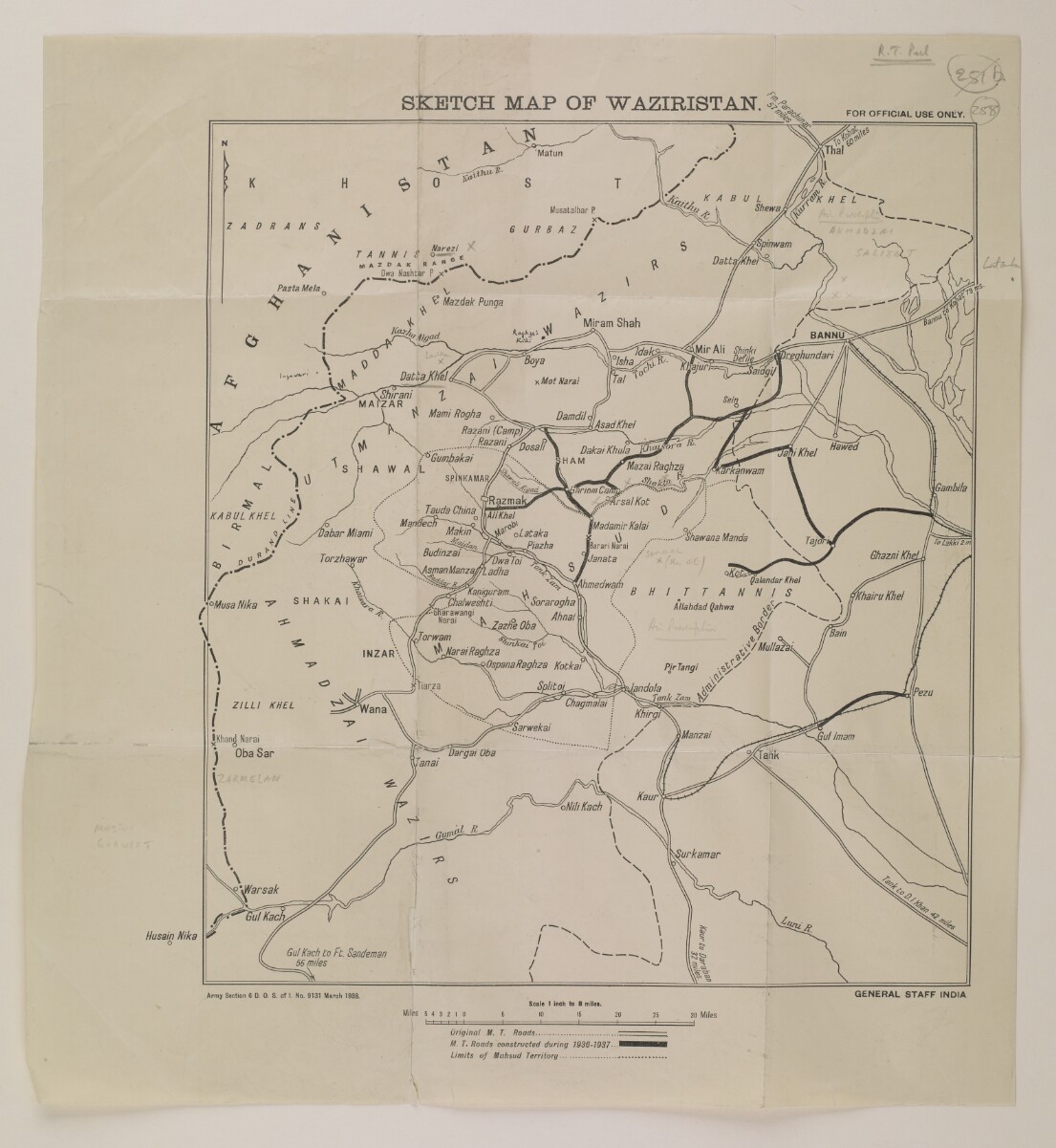
The map shows Waziristan, and the border between British India and Afghanistan. It indicates the extent of Mahsud territory, and includes road and rail links; roads built between 1936-7 have been highlighted.
The map is contained within an envelope (folio 257) bearing a broken Foreign Office wax seal. The seal bears the words ‘Secretary of State – Foreign Department’.
- Extent and format
- 1 map
- Area map covers
- Map loading...
- Scale
- 1:506880
- Scale designator
- Horizontal
- Orientation
- North
- Degree coordinates
- Top-left: 33° 23' 34.94" N, 69° 22' 33.3" E
Top-right: 33° 23' 34.94" N, 70° 41' 9.73" E
Bottom-left: 32° 28' 13.36" N, 69° 22' 33.3" E
Bottom-right: 32° 28' 13.36" N, 70° 41' 9.73" E - Physical characteristics
Materials: 1 paper folio
Dimensions: 358mm x 318mm
- Written in
- English in Latin script View the complete information for this record
Use and share this item
- Share this item
‘Sketch Map of Waziristan’ [258r] (1/2), British Library: India Office Records and Private Papers, IOR/L/PS/12/1960, f 258, in Qatar Digital Library <https://www.qdl.qa/archive/81055/vdc_100034973079.0x000073> [accessed 2 April 2025]
https://www.qdl.qa/en/archive/81055/vdc_100034973079.0x000073
Copy and paste the code below into your web page where you would like to embed the image.
<meta charset="utf-8"><a href="https://www.qdl.qa/en/archive/81055/vdc_100034973079.0x000073">‘Sketch Map of Waziristan’ [‎258r] (1/2)</a> <a href="https://www.qdl.qa/en/archive/81055/vdc_100034973079.0x000073"> <img src="https://iiif.qdl.qa/iiif/images/81055/vdc_100000000555.0x0001f2/IOR_L_PS_12_1960_0517.jp2/full/!280,240/0/default.jpg" alt="" /> </a>
This record has a IIIF manifest available as follows. If you have a compatible viewer you can drag the icon to load it.https://www.qdl.qa/en/iiif/81055/vdc_100000000555.0x0001f2/manifestOpen in Universal viewerOpen in Mirador viewerMore options for embedding images
Copyright: How to use this content
- Reference
- IOR/L/PS/12/1960, f 258
- Title
- ‘Sketch Map of Waziristan’
- Pages
- 258r:258v
- Author
- East India Company, the Board of Control, the India Office, or other British Government Department
- Usage terms
- Open Government Licence