!['Map of Damara and Great Namaqua Land and the Adjacent Countries to and beyond Lake Ngami as explored and surveyed by Messrs Galton & Andersson' [‎1r] (1/2)](https://iiif.qdl.qa/iiif/images/81055/vdc_100000001524.0x0003d7/Mss Eur F126_100_0001.jp2/full/!1200,1200/0/default.jpg "'Map of Damara and Great Namaqua Land and the Adjacent Countries to and beyond Lake Ngami as explored and surveyed by Messrs Galton & Andersson' [‎1r] (1/2)")
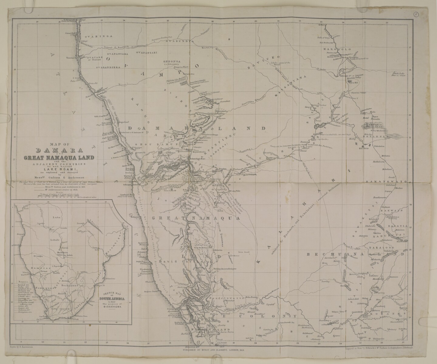
'Map of Damara and Great Namaqua Land and the Adjacent Countries to and beyond Lake Ngami as explored and surveyed by Messrs Galton & Andersson' [1r] (1/2)
The record is made up of 1 map. It was created in 1856. It was written in English. The original is part of the British Library: India Office The department of the British Government to which the Government of India reported between 1858 and 1947. The successor to the Court of Directors. Records and Private Papers Documents collected in a private capacity. .
About this item
- Content
Imprint:
London, Published by Hurst and Blackett. Drawn by E Ravenstein; Engraved on stone by Schenck and McFarlane Lithographers, Edinburgh.
Distinctive Features:
Relief shown by hachures.
Below title the note 'The coast from 20° South lat, to Walfisch Bay is from the survey of Capt. William Messum. The rest of the coast has been corrected from the observation of that navigator'.
Shows the routes of the expeditions: Messrs Galton and Andersson in 1851 by pecked line and Mr Andersson in 1853 by black line.
Includes an inset A small map or other image enclosed within the margin of a larger map, map sheet, or larger image; or papers placed inside a book or archival volume. : 'Sketch Map of South Africa to show the progress of discovery' which shows routes of various expeditions between 1812 and 1854.
- Extent and format
- 1 map
- Area map covers
- Map loading...
- Scale
- Scale approximately 1:3,301,600
- Scale designator
- Horizontal
- Orientation
- North
- Degree coordinates
- Top-left: -5° 14' 24" S, 10° 54' 0" E
Top-right: -5° 14' 24" S, 41° 31' 48" E
Bottom-left: -36° 3' 36" S, 10° 54' 0" E
Bottom-right: -36° 3' 36" S, 41° 31' 48" E - Physical characteristics
Dimensions: 421 x 512 mm; on sheet 451 x 548 mm
Foliation: The map has been foliated in the top right hand corner with a pencil number enclosed in a circle.
- Written in
- English in Latin script View the complete information for this record
Use and share this item
- Share this item
'Map of Damara and Great Namaqua Land and the Adjacent Countries to and beyond Lake Ngami as explored and surveyed by Messrs Galton & Andersson' [1r] (1/2), British Library: India Office Records and Private Papers, Mss Eur F126/100, in Qatar Digital Library <https://www.qdl.qa/archive/81055/vdc_100025717369.0x000002> [accessed 4 March 2025]
https://www.qdl.qa/en/archive/81055/vdc_100025717369.0x000002
Copy and paste the code below into your web page where you would like to embed the image.
<meta charset="utf-8"><a href="https://www.qdl.qa/en/archive/81055/vdc_100025717369.0x000002">'Map of Damara and Great Namaqua Land and the Adjacent Countries to and beyond Lake Ngami as explored and surveyed by Messrs Galton & Andersson' [‎1r] (1/2)</a> <a href="https://www.qdl.qa/en/archive/81055/vdc_100025717369.0x000002"> <img src="https://iiif.qdl.qa/iiif/images/81055/vdc_100000001524.0x0003d7/Mss Eur F126_100_0001.jp2/full/!280,240/0/default.jpg" alt="" /> </a>
This record has a IIIF manifest available as follows. If you have a compatible viewer you can drag the icon to load it.https://www.qdl.qa/en/iiif/81055/vdc_100000001524.0x0003d7/manifestOpen in Universal viewerOpen in Mirador viewerMore options for embedding images
Copyright: How to use this content
- Reference
- Mss Eur F126/100
- Title
- 'Map of Damara and Great Namaqua Land and the Adjacent Countries to and beyond Lake Ngami as explored and surveyed by Messrs Galton & Andersson'
- Pages
- 1r:1v
- Author
- Random House (xHurst and Blackett)
- Usage terms
- Public Domain