!['ROUTES IN PERSIA. SECTION III' [‎152r] (308/739)](https://iiif.qdl.qa/iiif/images/81055/vdc_100000001491.0x000114/Mss Eur F111_371_0306.jp2/full/!1200,1200/0/default.jpg "'ROUTES IN PERSIA. SECTION III' [‎152r] (308/739)")
'ROUTES IN PERSIA. SECTION III' [152r] (308/739)
The record is made up of 1 volume (367 folios). It was created in 1898. It was written in English. The original is part of the British Library: India Office The department of the British Government to which the Government of India reported between 1858 and 1947. The successor to the Court of Directors. Records and Private Papers Documents collected in a private capacity. .
Transcription
This transcription is created automatically. It may contain errors.
3%
m
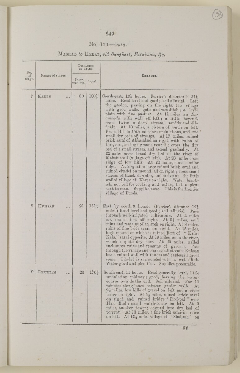
No. 136— contd,
M ashad to H erat, vid Sang hast, Faraiman, fyc.
No.
of
stage.
Names of stages.
D istances
tk miles.
Inter
mediate.
Total.
Ebmaeks.
Kabez
KuhsaN
GnrEiAN
30
21
25
mi
South-east, 121 hours. Ferrier's distance is 31|
miles. Road level and good; soil alluvial. Left
the garden, passing on the right the village
with good walls, gate and wet ditch ; a level
plain with fine pasture. At 1J- miles an Jm-
amzada with wall off left; a little beyond,
cross twice a deep stream, muddy and dif
ficult. At 10 miles, a cistern of water on left.
From 14th to 15th miles are undulations, and two '
small dry beds of streams. At 17 miles, rained
brick sarai of Abbasabad on rigjit, with ruins of
fort, etc., on high ground near it ; cross the dry
bed of a small stream, and ascend gradually. At
22 miles cross broad dry bed of the river of
Mohsinabad (village off left). At 23 miles cross
ridge of low hills. At 24 miles, cross similar
ridge. At 29i miles large ruined brick sarai and
ruined citadel on mound, all on right ; cross small
stream of brackish water, and arrive at the little
walled village of Karez on right. Water brack
ish, not bad for cooking and cattle, but unplea
sant to man. Supplies none. This is the frontier
village of Persia.
East by south 9 hours. (Ferrier's distance 17J
miles.) Road level and good ; soil alluvial. Pass
through well-irrigated cultivation. At 4 miles
is a ruined fort off right. At 6J miles, mud
ruins and remains of an arch on right. At 8 miles,
ruins of fine brick sarai on right. At 15 miles,
high mound on which is ruined Fort of " Kafir-
Kala," sarai opposite. At 19 miles., cross the river,
which is quite dry here. At 20 miles, walled
enclosures, ruins and remains of gardens. Pass
through the'village and cross small stream. Kuhsan
has a ruined wall with towers and encloses a great
space. Citadel is surrounded with a wet ditch.
Water good and plentiful. Supplies procurable.
South-east, 11 hours. Eoad generally level, little
undulating midway ; good, barring the water
course towards the end. Soil alluvial. For 10
minutes along lanes between garden walls. At
2j- miles, low hills of gravel on left, and a river
below on right. At 5^ miles, ruined brick sarai
on right, and ruined bridge " Tir-i-pul " over
Hari Kud ; small watch-tower on left. At 9
miles, another tower; descend into dry bed of
torrent. At 13 miles, a fine brick sarai»in ruins
on left. At 13J miles village of " Shabash " on
About this item
- Content
The volume is a Government of India official publication entitled Routes in Persia. Section III. Compiled in the Intelligence Branch of the Quarter Master General's Department in India (Simla: printed at the Government Central Printing Office, 1898).
The volume contains details of all land routes (numbered 1-247) in Persia starting from Russian territory and extending south as far as a line drawn from Karmanshah [Kermānshāh] south-eastwards through Burujird [Borūjerd], Isfahan [Eşfahān] and Yazd to Karman [Kermān], and thence north-east to Khabis [Khabīş] and Neh to Lash Juwain [Lāsh-e Juwayn].
The information given for each route comprises:
- number of route;
- place names forming starting point and destination of route;
- authority and date;
- number of stage;
- names of stages;
- distance in miles (intermediate and total);
- remarks (including precise details of the route, general geographical information, and information on smaller settlements, local peoples, agriculture, condition of roads, access to water, supplies of wood, and other routes).
An appendix within the volume (folios 356-359) and two separately-stored sets of loose sheets (containing routes numbers 77 (a) and 140-A, folios 363-369) give information too late for incorporation in the body of the work.
The volume also contains pockets attached to the front and back inside covers for maps. These consist of an index map showing the limits of each of the three sections of Routes in Persia (folio 2) and an index map to the routes in Section III (folio 361). There is also a fold-out map of the route from Seistan [Sīstān] to Mashad on folio 232.
An ink stamp on the front cover records the confidential nature of the publication and that it was being transmitted for the information of His Excellency the Viceroy (Victor Alexander Bruce, 9th Earl of Elgin and 16th Earl of Kincardine) only.
- Extent and format
- 1 volume (367 folios)
- Arrangement
The volume contains an alphabetical cross index (folios 6-17), and an alphabetical index to names of places (folios 18-25).
- Physical characteristics
Foliation: the foliation sequence commences at the front cover and terminates on the last page of the loose supplementary sheets (found in the small grey folder within the main folder); these numbers are written in pencil, are circled, and are located in the top right corner of the recto The front of a sheet of paper or leaf, often abbreviated to 'r'. side of each folio.
Pagination: the volume also contains a printed pagination sequence.
- Written in
- English in Latin script View the complete information for this record
Use and share this item
- Share this item
'ROUTES IN PERSIA. SECTION III' [152r] (308/739), British Library: India Office Records and Private Papers, Mss Eur F111/371, in Qatar Digital Library <https://www.qdl.qa/archive/81055/vdc_100024054421.0x00006b> [accessed 13 March 2025]
https://www.qdl.qa/en/archive/81055/vdc_100024054421.0x00006b
Copy and paste the code below into your web page where you would like to embed the image.
<meta charset="utf-8"><a href="https://www.qdl.qa/en/archive/81055/vdc_100024054421.0x00006b">'ROUTES IN PERSIA. SECTION III' [‎152r] (308/739)</a> <a href="https://www.qdl.qa/en/archive/81055/vdc_100024054421.0x00006b"> <img src="https://iiif.qdl.qa/iiif/images/81055/vdc_100000001491.0x000114/Mss Eur F111_371_0306.jp2/full/!280,240/0/default.jpg" alt="" /> </a>
This record has a IIIF manifest available as follows. If you have a compatible viewer you can drag the icon to load it.https://www.qdl.qa/en/iiif/81055/vdc_100000001491.0x000114/manifestOpen in Universal viewerOpen in Mirador viewerMore options for embedding images
Copyright: How to use this content
- Reference
- Mss Eur F111/371
- Title
- 'ROUTES IN PERSIA. SECTION III'
- Pages
- front, back, spine, edge, head, tail, front-i, 2r:58r, 59r:232r, 232r:233r, 234r:361v, back-i, 363r:363v, 365r:369v
- Author
- East India Company, the Board of Control, the India Office, or other British Government Department
- Usage terms
- Open Government Licence