!['ROUTES IN PERSIA. SECTION III' [‎146v] (297/739)](https://iiif.qdl.qa/iiif/images/81055/vdc_100000001491.0x000114/Mss Eur F111_371_0295.jp2/full/!1200,1200/0/default.jpg "'ROUTES IN PERSIA. SECTION III' [‎146v] (297/739)")
'ROUTES IN PERSIA. SECTION III' [146v] (297/739)
The record is made up of 1 volume (367 folios). It was created in 1898. It was written in English. The original is part of the British Library: India Office The department of the British Government to which the Government of India reported between 1858 and 1947. The successor to the Court of Directors. Records and Private Papers Documents collected in a private capacity. .
Transcription
This transcription is created automatically. It may contain errors.
238
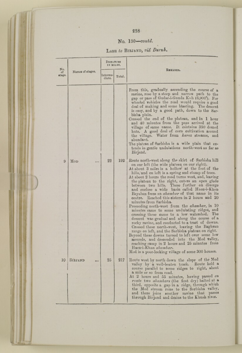
No. \2>§' mmm C0)itd.
Lash to Birjand, via Duruh*
No.
of
•tage.
DisTAircKa
IN MILES,
B BUABZEI.
%
Names of stages.
Interroe-
diate.
Total.
10
Mod
Biejand
22
25
192
217
From this, gradually ascending the course of a
ravine, rose by a steep and narrow path to the
gap or pass of Gudar-i-Gunda Kuh {6,900'). For
wheeled vehicles the road would require a good
deal of making and some blasting. The descent
is easy, and by a good path, down to the Sar-
bisha plain.
Crossed the end of the plateau, and in 1 hour
and 40 minutes from the pass arrived at the
village of same name. It contains 350 domed
buts. A good deal of corn cultivation around
the village. Water from karez streams, and
abundant.
The plateau of Sarbisba is a wide plain that ex
tends in gentle undulations north-w 7 est as far a»
Birjand.
Eoute north-west along the skirt of Sarbisha hiD
on our left (the wide plateau on our right).
At about B miles is a hollow' at the foot of the
hills, and on left is a spring and clump of trees.
At about 2 hours the road turns west, and, leaving
the plateau to the right, enters an open glade
between two hills. These further on diverge
and enclose a wide basin called Haoz-i-Khnn
Bayaban from an ahambar of that name in its-
centre. Eeached this cistern in 2 hours and 20
minutes from Sarbisha.
Proceeding north-west from the ahamhar, in 10
minutes came to some undulating ridges, and
crossing these came to a low watershed. The
descent was gradual and along the course of a
rocky ravine, and conducted to a tract of downs.
Crossed these north-west, leaving the Baghran
range on left, and the Sarbisha plateau on right.
Beyond these downs turned to left over some low
mounds, and descended into the Mod valley,
reaching camp in 2 hours and 25 minutes from
Haoz-i-Khan ahamhar*
Mod is a poor-looking village of some 300 houses.
Route west by north down the slope of the Mod
valley by a well-beaten track. Route held a
course parallel to some ridges to right, about
a mile or so from road.
At 2 hours and 55 minutes, having passed en
route two ahambars (the first dry) halted at a
third, opposite a gap in a ridge, through which
the Mod stream runs to the Sarbisha valley,
and there joins another ravine that passes
through Birjund and drains to the Khush river.
About this item
- Content
The volume is a Government of India official publication entitled Routes in Persia. Section III. Compiled in the Intelligence Branch of the Quarter Master General's Department in India (Simla: printed at the Government Central Printing Office, 1898).
The volume contains details of all land routes (numbered 1-247) in Persia starting from Russian territory and extending south as far as a line drawn from Karmanshah [Kermānshāh] south-eastwards through Burujird [Borūjerd], Isfahan [Eşfahān] and Yazd to Karman [Kermān], and thence north-east to Khabis [Khabīş] and Neh to Lash Juwain [Lāsh-e Juwayn].
The information given for each route comprises:
- number of route;
- place names forming starting point and destination of route;
- authority and date;
- number of stage;
- names of stages;
- distance in miles (intermediate and total);
- remarks (including precise details of the route, general geographical information, and information on smaller settlements, local peoples, agriculture, condition of roads, access to water, supplies of wood, and other routes).
An appendix within the volume (folios 356-359) and two separately-stored sets of loose sheets (containing routes numbers 77 (a) and 140-A, folios 363-369) give information too late for incorporation in the body of the work.
The volume also contains pockets attached to the front and back inside covers for maps. These consist of an index map showing the limits of each of the three sections of Routes in Persia (folio 2) and an index map to the routes in Section III (folio 361). There is also a fold-out map of the route from Seistan [Sīstān] to Mashad on folio 232.
An ink stamp on the front cover records the confidential nature of the publication and that it was being transmitted for the information of His Excellency the Viceroy (Victor Alexander Bruce, 9th Earl of Elgin and 16th Earl of Kincardine) only.
- Extent and format
- 1 volume (367 folios)
- Arrangement
The volume contains an alphabetical cross index (folios 6-17), and an alphabetical index to names of places (folios 18-25).
- Physical characteristics
Foliation: the foliation sequence commences at the front cover and terminates on the last page of the loose supplementary sheets (found in the small grey folder within the main folder); these numbers are written in pencil, are circled, and are located in the top right corner of the recto The front of a sheet of paper or leaf, often abbreviated to 'r'. side of each folio.
Pagination: the volume also contains a printed pagination sequence.
- Written in
- English in Latin script View the complete information for this record
Use and share this item
- Share this item
'ROUTES IN PERSIA. SECTION III' [146v] (297/739), British Library: India Office Records and Private Papers, Mss Eur F111/371, in Qatar Digital Library <https://www.qdl.qa/archive/81055/vdc_100024054421.0x000060> [accessed 13 March 2025]
https://www.qdl.qa/en/archive/81055/vdc_100024054421.0x000060
Copy and paste the code below into your web page where you would like to embed the image.
<meta charset="utf-8"><a href="https://www.qdl.qa/en/archive/81055/vdc_100024054421.0x000060">'ROUTES IN PERSIA. SECTION III' [‎146v] (297/739)</a> <a href="https://www.qdl.qa/en/archive/81055/vdc_100024054421.0x000060"> <img src="https://iiif.qdl.qa/iiif/images/81055/vdc_100000001491.0x000114/Mss Eur F111_371_0295.jp2/full/!280,240/0/default.jpg" alt="" /> </a>
This record has a IIIF manifest available as follows. If you have a compatible viewer you can drag the icon to load it.https://www.qdl.qa/en/iiif/81055/vdc_100000001491.0x000114/manifestOpen in Universal viewerOpen in Mirador viewerMore options for embedding images
Copyright: How to use this content
- Reference
- Mss Eur F111/371
- Title
- 'ROUTES IN PERSIA. SECTION III'
- Pages
- front, back, spine, edge, head, tail, front-i, 2r:58r, 59r:232r, 232r:233r, 234r:361v, back-i, 363r:363v, 365r:369v
- Author
- East India Company, the Board of Control, the India Office, or other British Government Department
- Usage terms
- Open Government Licence