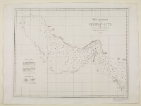
‘MAY’
IOR/X/3635/29/5
2 items in this record
Search within this record
The record is made up of 1 map. It was created in Apr 1856. It was written in English. The original is part of the British Library: Map Collections.
About this record
- Extent and format
- 1 map
- Area map covers
- Map loading...
- Scale
- Scale not given
- Scale designator
- Horizontal
- Orientation
- North
- Degree coordinates
- Top-left: 30° 39' 2.52" N, 47° 25' 21" E
Top-right: 30° 39' 2.52" N, 60° 0' 34.2" E
Bottom-left: 21° 29' 47.76" N, 47° 25' 21" E
Bottom-right: 21° 29' 47.76" N, 60° 0' 34.2" E - It is part of
- 24 imagesRef: IOR/X/3635/29
- Physical characteristics
Dimensions:
428 x 557 mm, on sheet 508 x 689 mm
- Written in
- English in Latin script
- Type
- Map
Archive information for this record
- Original held at
- British Library: Map Collections
- Access conditions
Unrestricted
- Archive reference
- IOR/X/3635/29/5
- Former British Library reference
- V.VII.29.(5.)
- Date(s)
- Apr 1856 (CE, Gregorian)
Access & Reference
History of this record
Use and share this record
- Share this record
- Cite this record in your research
‘MAY’, British Library: Map Collections, IOR/X/3635/29/5, in Qatar Digital Library <https://www.qdl.qa/universal-viewer/81055/vdc_100023867359.0x000009> [accessed 25 June 2026]
- Link to this record
https://www.qdl.qa/en/archive/81055/vdc_100023867359.0x000009
- IIIF details
This record has a IIIF manifest available as follows. If you have a compatible viewer you can drag the icon to load it.https://www.qdl.qa/en/iiif/81055/vdc_100000010812.0x000001/manifestOpen in Universal viewerOpen in Mirador viewerMore options for embedding images
Copyright: How to use this content
- Reference
- IOR/X/3635/29/5
- Title
- ‘MAY’
- Pages
- 5r:5v
- Author
- Please see item description
- Usage terms
- Public Domain