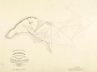
A map of pearl banks in Persian Gulf
IOR/R/15/1/616, f 13

2 items in this record
Search within this record
The record is made up of 1 map. It was created in 30 Jul 1940. It was written in Arabic. The original is part of the British Library: India Office The department of the British Government to which the Government of India reported between 1858 and 1947. The successor to the Court of Directors. Records and Private Papers Documents collected in a private capacity. .
About this record
- Content
Imprint:
‘Batliboi Litho Works, Bombay 8’.
Distinctive Features:
Pearl banks indicated by Arabic numerals, the names of topographic features including settlements, islands and pearl beds inserted in Arabic.
In the lower right-hand corner of the sheet a descriptive note from the author, this starts and ends with prayers. It includes explanation to the surveying methods and reasons for creating the map, as well as the author’s approval and stamp with his name (Shaykh Mani’ ibn al-Shaykh Rashid al-Maktum), the date: 24 Jumada II 1359 AH, and a note ‘all right reserved’.
Labels:
Stamp in purple ink which states in Arabic that the map is not to be translated to any other language without author’s permission.
- Extent and format
- 1 map
- Area map covers
- Map loading...
- Scale
- Scale not given
- Scale designator
- Horizontal
- Orientation
- North
- Degree coordinates
- Top-left: 27° 56' 31.56" N, 48° 46' 45.48" E
Top-right: 27° 56' 31.56" N, 56° 51' 23.04" E
Bottom-left: 23° 44' 51.72" N, 48° 46' 45.48" E
Bottom-right: 23° 44' 51.72" N, 56° 51' 23.04" E - It is part of
- 166 imagesRef: IOR/R/15/1/616
- Physical characteristics
Dimensions:
495 x 880 mm, on sheet 558 x 925 mm
- Written in
- Arabic in Arabic script
- Type
- Map
Archive information for this record
- Original held at
- British Library: India Office The department of the British Government to which the Government of India reported between 1858 and 1947. The successor to the Court of Directors. Records and Private Papers Documents collected in a private capacity.
- Access conditions
Unrestricted
- Archive reference
- IOR/R/15/1/616, f 13
- Date(s)
- 30 Jul 1940 (CE, Gregorian)
Access & Reference
History of this record
Related search terms
- Places
- Persian Gulf
Use and share this record
- Share this record
- Cite this record in your research
A map of pearl banks in Persian Gulf, British Library: India Office Records and Private Papers, IOR/R/15/1/616, f 13, in Qatar Digital Library <https://www.qdl.qa/archive/81055/vdc_100023720880.0x000004> [accessed 21 July 2026]
- Link to this record
https://www.qdl.qa/en/archive/81055/vdc_100023720880.0x000004
- IIIF details
This record has a IIIF manifest available as follows. If you have a compatible viewer you can drag the icon to load it.https://www.qdl.qa/en/iiif/81055/vdc_100000000193.0x00024d/manifestOpen in Universal viewerOpen in Mirador viewerMore options for embedding images
Copyright: How to use this content
- Reference
- IOR/R/15/1/616, f 13
- Title
- A map of pearl banks in Persian Gulf
- Pages
- 13r:13v
- Author
- Āl Maktūm, Shaikh Mani’ bin Rashid
- Usage terms
- The copyright status is unknown. Please contact [email protected] with any information you have regarding this item.