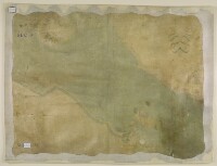
Chart of the Strait of Babellmandell made by John Friend Against ye East India hous in leaden hall Street London An.o Dn.o 1714
IOR/X/10308

2 items in this record
Search within this record
The record is made up of 1 map. It was created in 1714. It was written in English. The original is part of the British Library: Map Collections.
About this record
- Content
Distinctive Features:
Hand drawn nautical chart of the Strait of Babellmandell [Bab-el-Mandeb] at the south entrance into the Red Sea drawn by John Friend in 1714 to “A Scale of Twentey English Miles”.
Relief shown pictorially. Depths shown by soundings Measurements of the depth of a body of water. with reefs and shoals represented by crosses; positions for safe anchorage indicated.
Shows a central compass rose orienting east to the top of the map.
Includes a textual description of the Citty of Mocha with remarks on sailing directions.
MS annotation in ‘A Catalogue of Manuscript and Printed Reports, Field Books, Memoirs, Maps, etc., of the Indian Surveys, Deposited in the Map Room of the India Office’ published in 1878: ‘The chart is supposed to have belonged to Phillip Herbert Commander of the Euphrates, R. 1404/25’.
Inscriptions:
On verso The back of a sheet of paper or leaf, often abbreviated to 'v'. in the upper left in red ink: ‘R. 1404/25’ and below in black ink: ‘India Office: Map Drawer U.VI – folio 3’.
- Extent and format
- 1 map
- Area map covers
- Map loading...
- Scale
- Scale approximately 1:250,000
- Scale designator
- Horizontal
- Orientation
- East
- Degree coordinates
- Top-left: 13° 22' 28.6" N, 42° 19' 47.69" E
Top-right: 13° 22' 28.6" N, 43° 34' 54.81" E
Bottom-left: 12° 21' 58.27" N, 42° 19' 47.69" E
Bottom-right: 12° 21' 58.27" N, 43° 34' 54.81" E - Physical characteristics
Materials: Pen and ink with colour highlighting on parchment
Dimensions: 660 x 872 mm
- Written in
- English in Latin script
- Type
- Map
Archive information for this record
- Original held at
- British Library: Map Collections
- Access conditions
Unrestricted
- Archive reference
- IOR/X/10308
- Former external reference(s)
- R.X.15.
- Date(s)
- 1714 (CE, Gregorian)
Access & Reference
History of this record
Related search terms
- Places
- Babelmandel
Use and share this record
- Share this record
- Cite this record in your research
Chart of the Strait of Babellmandell made by John Friend Against ye East India hous in leaden hall Street London An.o Dn.o 1714, British Library: Map Collections, IOR/X/10308, in Qatar Digital Library <https://www.qdl.qa/archive/81055/vdc_100023622956.0x000001> [accessed 6 October 2024]
- Link to this record
https://www.qdl.qa/en/archive/81055/vdc_100023622956.0x000001
- IIIF details
This record has a IIIF manifest available as follows. If you have a compatible viewer you can drag the icon to load it.https://www.qdl.qa/en/iiif/81055/vdc_100023622956.0x000001/manifestOpen in Universal viewerOpen in Mirador viewerMore options for embedding images
Copyright: How to use this content
- Reference
- IOR/X/10308
- Title
- Chart of the Strait of Babellmandell made by John Friend Against ye East India hous in leaden hall Street London An.o Dn.o 1714
- Pages
- 1r:1v
- Author
- Friend, John
- Usage terms
- Public Domain