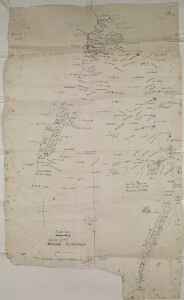
‘Rough Map of the KATAR PENINSULA’
IOR/R/15/1/370, f 164
2 items in this record
Search within this record
The record is made up of 1 map sheet. It was created in 1937?. It was written in English. The original is part of the British Library: India Office The department of the British Government to which the Government of India reported between 1858 and 1947. The successor to the Court of Directors. Records and Private Papers Documents collected in a private capacity. .
About this record
- Content
Distinctive Features:
Title corrected to: ‘Sketch map of the QATAR PENINSULA’.
Relief shown by hachures Lines drawn on a map to indicate the direction and steepness of slope. .
Coast between Zubara and Jabel al Tabena outlined in red.
Numerous additions and corrections to place names and topographical features.
‘Al Doha’ underlined in blue crayon and ‘DOHAH’ added in later hand with coordinates inserted in pencil and annotation: ‘All these villages now form the town of Dohah the capital of QATAR’.
- Extent and format
- 1 map sheet
- Area map covers
- Map loading...
- Scale
- approximately 1:250,000
- Scale designator
- Horizontal
- Orientation
- North
- Degree coordinates
- Top-left: 26° 20' 13.2" N, 50° 32' 8.88" E
Top-right: 26° 20' 13.2" N, 51° 38' 35.88" E
Bottom-left: 24° 28' 15.96" N, 50° 32' 8.88" E
Bottom-right: 24° 28' 15.96" N, 51° 38' 35.88" E - It is part of
- 444 imagesRef: IOR/R/15/1/370
- Physical characteristics
Material:
Pen and ink with wash on paper with additions in pencil
Dimensions:
765 x 460 mm
- Written in
- English in Latin script
- Type
- Map
Archive information for this record
- Original held at
- British Library: India Office The department of the British Government to which the Government of India reported between 1858 and 1947. The successor to the Court of Directors. Records and Private Papers Documents collected in a private capacity.
- Access conditions
Unrestricted
- Archive reference
- IOR/R/15/1/370, f 164
- Date(s)
- 1937? (CE, Gregorian)
Access & Reference
History of this record
Related material
Related search terms
Use and share this record
- Share this record
- Cite this record in your research
‘Rough Map of the KATAR PENINSULA’, British Library: India Office Records and Private Papers, IOR/R/15/1/370, f 164, in Qatar Digital Library <https://www.qdl.qa/archive/81055/vdc_100023556313.0x000001> [accessed 16 June 2026]
- Link to this record
https://www.qdl.qa/en/archive/81055/vdc_100023556313.0x000001
- IIIF details
This record has a IIIF manifest available as follows. If you have a compatible viewer you can drag the icon to load it.https://www.qdl.qa/en/iiif/81055/vdc_100000000193.0x000157/manifestOpen in Universal viewerOpen in Mirador viewerMore options for embedding images
Copyright: How to use this content
- Reference
- IOR/R/15/1/370, f 164
- Title
- ‘Rough Map of the KATAR PENINSULA’
- Pages
- 164r:164v
- Author
- East India Company, the Board of Control, the India Office, or other British Government Department
- Usage terms
- Open Government Licence