!['Gazetteer of the Persian Gulf. Vol. II. Geographical and Statistical. J G Lorimer. 1908' [‎420] (465/2084)](https://iiif.qdl.qa/iiif/images/81055/vdc_100000000884.0x00014b/IOR_L_PS_20_C91_4_0465.jp2/full/!1200,1200/0/default.jpg "'Gazetteer of the Persian Gulf. Vol. II. Geographical and Statistical. J G Lorimer. 1908' [‎420] (465/2084)")
'Gazetteer of the Persian Gulf. Vol. II. Geographical and Statistical. J G Lorimer. 1908' [420] (465/2084)
The record is made up of 1 volume (1952 pages). It was created in 1908. It was written in English and Arabic. The original is part of the British Library: India Office The department of the British Government to which the Government of India reported between 1858 and 1947. The successor to the Court of Directors. Records and Private Papers Documents collected in a private capacity. .
Transcription
This transcription is created automatically. It may contain errors.
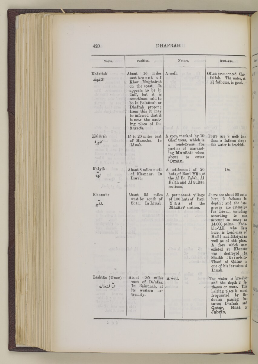
420
DHAFRAH
Name.
Position.
Nature.
Kafaifah
uakd]
About 16 miles
sout h-w est of
Khor Mughairah
on the coast. It
appears to be in
Taff, but it is
sometimes said to
be in Bainunah or
Dhafrah proper;
from this it may
be inferred tbat it
is near the meet
ing place of the
3 tracts.
A well.
Often pronounced ChU
faifah. The water, at
1^ fathoms, is good.
Kaiwrah
hji s
X.
15 to 20 miles east
of Hamaim. I d
Liwah.
A spot, marked by 10
Ghaf trees, which is
a rendezvous for
parties of maraud
ing Manasir when
about to enter
'Oman.
There are 8 wells less
than a fathom deep:
the water is brackish.
Kaiyih
W
&jS
w
ifj
About 8 miles north
of Khanrmr. In
Liwah.
A settlement of 20
huts of Bani Y5s oi
the A1 Bu Falah, A1
Falah and A1 Sultan
sections.
Do.
Khanniir
VJ
About 55 miles
west by south of
Shah. In Liwah.
A perinaDent village
of 100 huts of Bani
Y a 8 of the
MazarP section.
■
There are about 80 wells
here, 2 fathoms in
depth ; and the date
groves are extensiva
for Liwah, including
according to one
account as many as
14,000 palms. Paris-
bin-'Ali, who liveg
here, is head-man of
Hafif and Mariyah as
well as of this place.
A fort which once
existed at Khannur
was destroyed by
Shaikh Jasim-bin-
Thani of Qatar in
one of his invasions of
Liwah.
Lashtan (Umm)
About 30 miles
west of Da'afas.
In Bainunah, at
its western ex
tremity.
A well.
The water is brackish
and the depth 2 fa
thoms or more. This
halting place is much
frequented by Be
douins passing be
tween Dhafrah and
Qatar, Hasa or
Jabijin.
About this item
- Content
This volume is Volume II of the Gazetteer of the Persian Gulf The historical term used to describe the body of water between the Arabian Peninsula and Iran. , ’Omān and Central Arabia (Government of India: 1908) compiled by John Gordon Lorimer. The volume is a geographical dictionary with a series of alphabetically arranged articles relating to the physical and political conditions of the Persian Gulf The historical term used to describe the body of water between the Arabian Peninsula and Iran. and its surrounding areas.
Pages i-iv are an 'Introduction' to the volume written by John Gordon Lorimer at Strathmartine, Dundee, on 24 December 1908. Details are given within the introduction concerning the content and arrangement of principal and subordinate articles and explanations of estimates of distance and time and other statistical information.
Lorimer's introduction identifies the principal articles as:
- '’Omān Sultanate' (pages 1382-1425);
- '’Omān (Trucial)' [ Trucial Oman A name used by Britain from the nineteenth century to 1971 to refer to the present-day United Arab Emirates. ] (pages 1425-1451);
- 'Qatar' (pages 1505-1535);
- 'Bahrain Principality' (pages 233-253);
- 'Hasa Sanjāq' (pages 657-679);
- 'Kuwait Principality' (pages 1058-1077);
- 'Najd' (pages 1313-1351), supplemented by articles on 'Najd (Southern)' (pages 1351-1359), 'Qasīm' (pages 1485-1503) and 'Shammar (Jabal)' (pages 1732-1748);
- '’Irāq (Turkish)' (pages 759-882);
- '’Arabistān' (pages 115-151), suppplemented by articles on '’Arabistān (Northern)' (pages 151-157) and '’Arabistān (Southern)' (pages 157-165);
- 'Persian Coast' (pages 1455-1468);
- 'Makrān (Coast of Persian)' (pages 1130-1155).
All articles have a similar form. The English and Arabic place or tribe name appears in the right or left margin, followed by the text of the article split into sub-sections and with topographical information arranged in tables. Arabic words are given in the text next to their equivalent transliterated into Latin script, with the transliteration system employed appearing in 'Appendix S' in Volume I, Part II (IOR/L/PS/20/C91/2, pages 2737-2741).
Topics of information contained within the articles include: boundaries and sub-divisions; physical character and main features (for example, mountains and rivers); climate and seasons; natural products (vegetable, animal and mineral); agriculture and crops; livestock, including transport animals; inhabitants, with reference to racial and tribal distinctions, religious differences, mode of life, character, language, customs, dress and arms, and estimates of populations; trade (internal and external), with notice to currency, weights and measures, shipping, manufactures and industries, and miscellaneous occupations; communications by land and water, with descriptions of routes and estimates of transport; administration and government, especially police, justice, military resources, taxation and finance, and political constitution; and, international position and foreign interests, especially British and their representation in the country. Lorimer refers readers to the Appendices of Volume I, Part II (IOR/L/PS/20/C91/2, pages 2205-2741) for fuller details concerning: meteorology, health, date cultivation, transport animals and livestock, religions and sects, trade, sailing vessels, fisheries, pearl fisheries, and postal and telegraphic communications.
There are fifty-six folios lacking page numbers that contain illustrations. The images are labelled as follows:
- 'Wādi Bani Habīb in Jabal Akhdar'. Photographer: Major Percy Zachariah Cox;
- 'A Creek near Basrah from the Shatt=al=’Arab'. Photographer: Major Percy Zachariah Cox;
- 'Bridge of Boats, Baghdād'. Photographer: Major G Arbuthnot;
- 'The Hanaini well, Bahrain Island'. Photographer: John Calcott Gaskin;
- 'Ancient Tumuli, Bahrain Island'. Photographer: John Calcott Gaskin;
- 'Village of Qatārah Baraimi Oasis'. Photographer: Major Percy Zachariah Cox;
- 'The ’Ashshār creek in Basrah Town'. Photographer: Mr Albert Charles Wratislaw;
- 'The British Consulate. Basrah, from the Shatt=al=’Arab. (Consulate building on the right of picture)'. Photographer: Major Percy Zachariah Cox;
- 'Parade of British and Persian troops at Rīshehr, 1905';
- 'Part of the town of Būshehr';
- 'The Sea Front, Būshehr Town';
- 'The British Political Residency An office of the East India Company and, later, of the British Raj, established in the provinces and regions considered part of, or under the influence of, British India. , Būshehr';
- 'Bridge at Buziyeh'. Photographer: Major Percy Zachariah Cox;
- 'The Fort [Qasr al-Ḥuṣn] of the Shaikh at Abu Dhabi'. Photographer: Herr Hermann Burchardt;
- 'The Shaikh of Sharjah's Fort at Dhaid, Trucial Oman A name used by Britain from the nineteenth century to 1971 to refer to the present-day United Arab Emirates. '. Photographer: Major Percy Zachariah Cox;
- 'Dizfūl Town'. Photographer: Major G Arbuthnot;
- 'Dohah in Qatar'. Photographer: Herr Hermann Burchardt;
- 'A Canal in the Fallāhiyeh District'. Photographer: Major Percy Zachariah Cox;
- 'A Creek at Fāo'. Photographer: Mr W D Cumming;
- 'Muti at the head of Wādi Halfain'. Photographer: Major Percy Zachariah Cox;
- 'Near the village of Qārah in the Hasa Oasis'. Photographer: Herr Hermann Burchardt;
- 'The village of Qārah in the Hasa Oasis'. Photographer: Herr Hermann Burchardt;
- 'Desert bewteen the Hasa Oasis and Qatar'. Photographer: Herr Hermann Burchardt;
- 'The Imāmzādeh of Haidar Karār at the place of formation of the Hindiyān River'. Photographer: Major Percy Zachariah Cox;
- 'The Hindyān River near Zaidān'. Photographer: Major Percy Zachariah Cox;
- 'General View of Hofūf'. Photographer: Herr Hermann Burchardt;
- 'The Na’āthil Quarter, Hofūf'. Photographer: Herr Hermann Burchardt;
- 'Hormuz - View from the old Fort'. Photographer: Raja King Deen Dayal & Sons;
- 'Crowd at Rās=al-Khaimah'. Photographer: Major Percy Zachariah Cox;
- 'Rās=al-Khaimah, looking towards Ruūs=al=Jibāl'. Photographer: Major Percy Zachariah Cox;
- 'Kumzār'. Photographer: Herr Hermann Burchardt;
- 'The foreshore Kuwait, showing boat harbour'. Photographer: John Calcott Gaskin;
- 'Camel riders of the Shaikh of Kuwait'. Photographer: Raja King Deen Dayal & Sons;
- 'Lingeh';
- 'The Tīs Valley in Persian Makrān'. Photographer: Mr R H New;
- 'Country between the Bīr and Kair Rivers in Persian Makrān'. Photographer: Mr R H New;
- 'Mouth of the Tīs valley looking seawards'. Photographer: Mr R H New;
- 'The British Agency An office of the East India Company and, later, of the British Raj, headed by an agent. , Manāmah, Bahrain'. Photographer: Major Percy Zachariah Cox;
- 'An Arab of the Manāsīr tribe'. Photographer: Herr Hermann Burchardt;
- 'The Cemetery, Maqlab. (From A Photograph in the Possession of H Gabler, Esq, I E T D)';
- 'Eastern end of Masqat Town, British Consulate on the left, Sultan's palace on the right'. Photographer: Major Percy Zachariah Cox;
- 'West end of Masqat Town from Sultan's Palace. & Fort Mīrāni'. Photographer: Major Percy Zachariah Cox;
- 'Centre and Western end of Masqat Town with part of the Harbour'. Photographer: Major Percy Zachariah Cox;
- 'View of Wādi Mi’aidin from Sharaijah'. Photographer: Major Percy Zachariah Cox;
- 'River Scene Muhammareh'. Photographer: Major Percy Zachariah Cox;
- 'Two Views of Muhammareh Town'. Photographer: John Calcott Gaskin;
- 'Persian Battery at Muhammareh'. Photographer: Major Percy Zachariah Cox;
- 'View at Haz’=Dhabi, Trucial Oman A name used by Britain from the nineteenth century to 1971 to refer to the present-day United Arab Emirates. '. Photographer: Major Percy Zachariah Cox;
- '’Oqair Port'. Photographer: Herr Hermann Burchardt;
- 'Salt Rocks on Qishm Island near Namakdān'. Photographer: Raja King Deen Dayal & Sons;
- 'The "Earl Canning" lying in Elphinstone inlet, Ruus=al=Jibal 1868. [Head of Inlet.] From A Photograph in the Possession of H Gabler, Esq, I E T D)';
- ' Wadi A seasonal or intermittent watercourse, or the valley in which it flows. Samail near Hisn Samail'. Photographer: Major Percy Zachariah Cox;
- 'Eastern Face of Jabal=ash=Sham';
- 'The port of Sur'. Photographer: Major Percy Zachariah Cox;
- 'Bilād=as=Sur'. Photographer: Major Percy Zachariah Cox;
- 'The Fort of Wakrah, Qatar'. Photographer: Major Percy Zachariah Cox.
- Extent and format
- 1 volume (1952 pages)
- Arrangement
Following the title pages and 'Introduction', entries are arranged in alphabetical order from '’Abādilah' to 'Zubair Town'.
- Physical characteristics
Foliation: The foliation sequence is circled in pencil in the top right corner of the recto The front of a sheet of paper or leaf, often abbreviated to 'r'. of each folio. It begins on the first folio with text, on number 1, and ends on the last folio with text, on number 1034. It should be noted that f. 192 is followed by f. 192A.
- Written in
- English and Arabic in Latin and Arabic script View the complete information for this record
Use and share this item
- Share this item
'Gazetteer of the Persian Gulf. Vol. II. Geographical and Statistical. J G Lorimer. 1908' [420] (465/2084), British Library: India Office Records and Private Papers, IOR/L/PS/20/C91/4, in Qatar Digital Library <https://www.qdl.qa/archive/81055/vdc_100023515713.0x000042> [accessed 22 March 2025]
https://www.qdl.qa/en/archive/81055/vdc_100023515713.0x000042
Copy and paste the code below into your web page where you would like to embed the image.
<meta charset="utf-8"><a href="https://www.qdl.qa/en/archive/81055/vdc_100023515713.0x000042">'Gazetteer of the Persian Gulf. Vol. II. Geographical and Statistical. J G Lorimer. 1908' [‎420] (465/2084)</a> <a href="https://www.qdl.qa/en/archive/81055/vdc_100023515713.0x000042"> <img src="https://iiif.qdl.qa/iiif/images/81055/vdc_100000000884.0x00014b/IOR_L_PS_20_C91_4_0465.jp2/full/!280,240/0/default.jpg" alt="" /> </a>
This record has a IIIF manifest available as follows. If you have a compatible viewer you can drag the icon to load it.https://www.qdl.qa/en/iiif/81055/vdc_100000000884.0x00014b/manifestOpen in Universal viewerOpen in Mirador viewerMore options for embedding images
Copyright: How to use this content
- Reference
- IOR/L/PS/20/C91/4
- Title
- 'Gazetteer of the Persian Gulf. Vol. II. Geographical and Statistical. J G Lorimer. 1908'
- Pages
- front, back, spine, edge, head, tail, front-i, i-r:iii-v, 1:4, 1:60, 60a:60b, 61:96, 96a:96b, 97:200, 200a:200b, 201:230, 230a:230b, 231:232, 232a:232b, 233:262, 262a:262b, 263:272, 272a:272b, 273:274, 274b, 275:336, 336b, 337:340, 340b, 341:342, 342b, 343:348, 348b, 349:350, 350a:350b, 351:410, 410b, 411:434, 434a:434b, 435:484, 484a:484b, 485:488, 488b, 489:518, 518a:518b, 519:536, 536b, 537:616, 616a:616b, 617:642, 642b, 643:650, 650b, 651:660, 660b, 661:732, 732a:732b, 733:734, 734a:734b, 735:744, 744b, 745:746, 746b, 747:750, 750b, 751:1006, 1006a:1006b, 1007:1008, 1008a:1008b, 1009:1040, 1040b, 1041:1048, 1048a:1048b, 1049:1074, 1074b, 1075:1096, 1096b, 1097:1132, 1132a:1132b, 1133:1140, 1140a:1140b, 1141:1154, 1154a:1154b, 1155:1158, 1158a:1158b, 1159:1162, 1162b, 1163:1168, 1168b, 1169:1180, 1180a:1180b, 1181:1182, 1182a:1182b, 1183:1184, 1184a:1184b, 1185:1204, 1204a:1204b, 1205:1256, 1256a:1256b, 1257:1262, 1262a:1262b, 1263:1264, 1264a:1264b, 1265:1442, 1442a:1442b, 1443:1454, 1454b, 1455:1548, 1548b, 1549:1604, 1604b, 1605:1668, 1668a:1668b, 1669:1694, 1694b, 1695:1848, 1848a:1848b, 1849:1850, 1850a:1850b, 1851:1926, 1926a:1926b, 1927:1952, iv-r:iv-v, back-i
- Author
- East India Company, the Board of Control, the India Office, or other British Government Department
- Usage terms
- Open Government Licence