![‘Rough sketch showing Iraq territorial waters boundary’ [‎149r] (1/2)](https://iiif.qdl.qa/iiif/images/81055/vdc_100000000193.0x0001f8/IOR_R_15_1_531_0314.jp2/full/!1200,1200/0/default.jpg "‘Rough sketch showing Iraq territorial waters boundary’ [‎149r] (1/2)")
‘Rough sketch showing Iraq territorial waters boundary’ [149r] (1/2)
The record is made up of 1 map. It was created in 1933. It was written in English. The original is part of the British Library: India Office The department of the British Government to which the Government of India reported between 1858 and 1947. The successor to the Court of Directors. Records and Private Papers Documents collected in a private capacity. .
About this item
- Content
Distinctive Features:
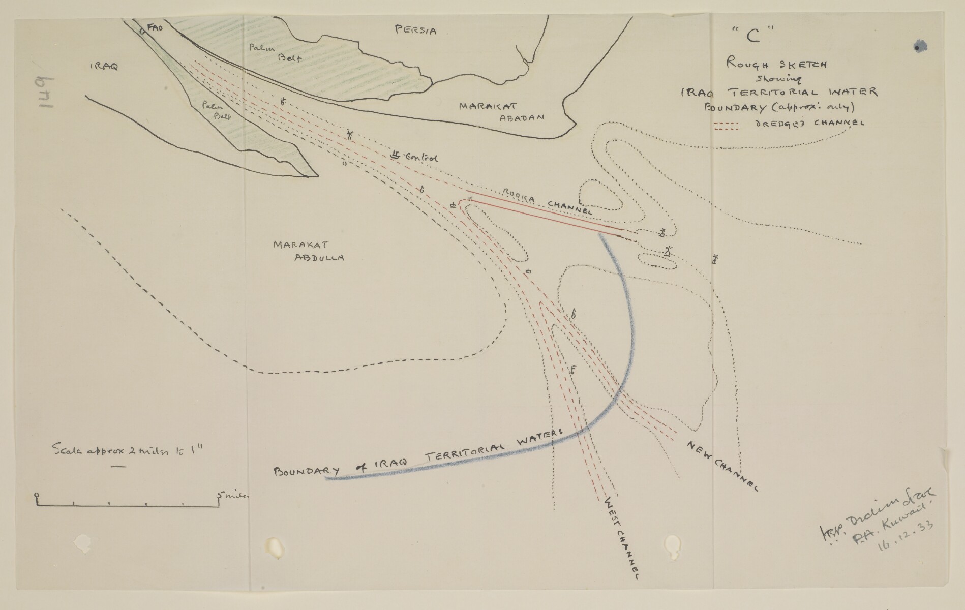
Copy a sketch map of the mouth and bar of the Shatt al Arab, attached to a letter no. 298.
Map based on material submitted by Lieutenant Thomas, R.N, Navigation Officer of H.M.S. Shoreham, showing the approximate boundary of Iraq territorial waters towards to open sea (blue line), with channels and buoys indicated. Signed in the bottom right-hand corner ‘J.R.P. Dickson, P.A. Kuwait’ and dated ’16.12.33’.
Another copy of the map can be found at folio 148.
- Extent and format
- 1 map
- Area map covers
- Map loading...
- Scale
- Scale approximately 1:125,000
- Scale designator
- Horizontal
- Orientation
- North
- Degree coordinates
- Top-left: 30° 3' 48.56" N, 48° 25' 29.41" E
Top-right: 30° 3' 48.56" N, 48° 50' 32.8" E
Bottom-left: 29° 45' 30.61" N, 48° 25' 29.41" E
Bottom-right: 29° 45' 30.61" N, 48° 50' 32.8" E - Physical characteristics
Materials: Pen and ink with crayon on tracing paper
Dimensions: 202 x 329 mm
- Written in
- English in Latin script View the complete information for this record
Use and share this item
- Share this item
‘Rough sketch showing Iraq territorial waters boundary’ [149r] (1/2), British Library: India Office Records and Private Papers, IOR/R/15/1/531, f 149, in Qatar Digital Library <https://www.qdl.qa/archive/81055/vdc_100023510123.0x000072> [accessed 1 April 2025]
https://www.qdl.qa/en/archive/81055/vdc_100023510123.0x000072
Copy and paste the code below into your web page where you would like to embed the image.
<meta charset="utf-8"><a href="https://www.qdl.qa/en/archive/81055/vdc_100023510123.0x000072">‘Rough sketch showing Iraq territorial waters boundary’ [‎149r] (1/2)</a> <a href="https://www.qdl.qa/en/archive/81055/vdc_100023510123.0x000072"> <img src="https://iiif.qdl.qa/iiif/images/81055/vdc_100000000193.0x0001f8/IOR_R_15_1_531_0314.jp2/full/!280,240/0/default.jpg" alt="" /> </a>
This record has a IIIF manifest available as follows. If you have a compatible viewer you can drag the icon to load it.https://www.qdl.qa/en/iiif/81055/vdc_100000000193.0x0001f8/manifestOpen in Universal viewerOpen in Mirador viewerMore options for embedding images
Copyright: How to use this content
- Reference
- IOR/R/15/1/531, f 149
- Title
- ‘Rough sketch showing Iraq territorial waters boundary’
- Pages
- 149r:149v
- Author
- East India Company, the Board of Control, the India Office, or other British Government Department
- Usage terms
- Open Government Licence