‘Chart of the South Coast of the Persian Gulph from Shaum to Ul Umrah by Philip Maughan. 1821. Drawn by M. Houghton’
IOR/X/3681
2 items in this record
Search within this record
The record is made up of 1 map. It was created in 1821. It was written in English. The original is part of the British Library: Map Collections.
About this record
- Content
Distinctive Features:
Relief shown by hachures. Depths shown by soundings Measurements of the depth of a body of water. .
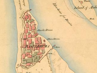
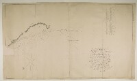
Hand drawn nautical chart of the shores of the Persian Gulf The historical term used to describe the body of water between the Arabian Peninsula and Iran. compiled from the survey carried out by the Bombay Marine’s officers in 1821 showing the western coastline from Shaum [Ash Sha‘m or Sha’am] to Ul Umrah [Jazīrah al Ḩamrā’].
Below title a note: ‘I was assisted in the execution of the Survey by Lieut.t J.M. Guy Command.s the H.C. Cruizer Psyche, & by Lieut.ts R.Cogan, W.E. Rogers & M. Houghton. P.M. [Philip Maughan]’.
Includes a descriptive note with remarks on survey execution with details on hazardous features and coastal topography. Latitude of Shaum reported; a network of triangles inserted on the map in red ink.
The location of ruins of Ras el Khyma and fishermen huts indicated with shoals and rocks represented by crosses.
Contains dedication to the Court of Directors The London-based directors of the East India Company who dealt with the daily conduct of the Company's affairs. of the United East India Company from Philip Maughan.
Oriented with south to the top.
- Extent and format
- 1 map
- Area map covers
- Map loading...
- Scale
- Scale approximately 1:48,000
- Scale designator
- Horizontal
- Orientation
- South
- Degree coordinates
- Top-left: 26° 8' 22.56" N, 55° 30' 27.36" E
Top-right: 26° 8' 22.56" N, 56° 9' 29.16" E
Bottom-left: 25° 22' 20.64" N, 55° 30' 27.36" E
Bottom-right: 25° 22' 20.64" N, 56° 9' 29.16" E - Physical characteristics
Materials: Pen and ink on paper
Dimensions: 733 x 1245 mm, on sheet 765 x 1308 mm
- Written in
- English in Latin script
- Type
- Map
Archive information for this record
- Original held at
- British Library: Map Collections
- Access conditions
Unrestricted
- Archive reference
- IOR/X/3681
- Former external reference(s)
- U.VI.36
- Date(s)
- 1821 (CE, Gregorian)
Access & Reference
History of this record
Related search terms
- Places
- Rass el Khyma
- People & organisations
- Philip MaughanJohn M. GuyRobert CoganMichael Houghton
Use and share this record
- Share this record
- Cite this record in your research
‘Chart of the South Coast of the Persian Gulph from Shaum to Ul Umrah by Philip Maughan. 1821. Drawn by M. Houghton’, British Library: Map Collections, IOR/X/3681, in Qatar Digital Library <https://www.qdl.qa/archive/81055/vdc_100023472745.0x000001> [accessed 5 July 2024]
- Link to this record
https://www.qdl.qa/en/archive/81055/vdc_100023472745.0x000001
- IIIF details
This record has a IIIF manifest available as follows. If you have a compatible viewer you can drag the icon to load it.https://www.qdl.qa/en/iiif/81055/vdc_100023472745.0x000001/manifestOpen in Universal viewerOpen in Mirador viewerMore options for embedding images
Copyright: How to use this content
- Reference
- IOR/X/3681
- Title
- ‘Chart of the South Coast of the Persian Gulph from Shaum to Ul Umrah by Philip Maughan. 1821. Drawn by M. Houghton’
- Pages
- 1r:1v
- Author
- Please see item description
- Usage terms
- Public Domain