!['CHART SHOWING PEARL BANKS ALONG ARABIAN SHORE OF THE PERSIAN GULF BETWEEN RAS TANURA AND DABAI' [‎3r] (1/2)](https://iiif.qdl.qa/iiif/images/81055/vdc_100000000193.0x00024d/IOR_R_15_1_616_0004.jp2/full/!1200,1200/0/default.jpg "'CHART SHOWING PEARL BANKS ALONG ARABIAN SHORE OF THE PERSIAN GULF BETWEEN RAS TANURA AND DABAI' [‎3r] (1/2)")
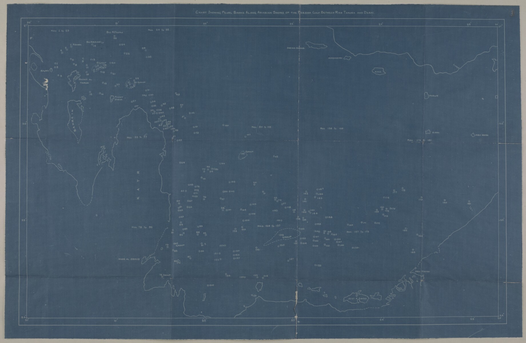
'CHART SHOWING PEARL BANKS ALONG ARABIAN SHORE OF THE PERSIAN GULF BETWEEN RAS TANURA AND DABAI' [3r] (1/2)
The record is made up of 1 map. It was created in c 1939. It was written in English. The original is part of the British Library: India Office The department of the British Government to which the Government of India reported between 1858 and 1947. The successor to the Court of Directors. Records and Private Papers Documents collected in a private capacity. .
About this item
- Content
Distinctive Features:
Blueprint showing the locations of pearling banks on the Trucial Coast A name used by Britain from the nineteenth century to 1971 to refer to the present-day United Arab Emirates. indicated by numbered small circles with a dot in centre.
- Extent and format
- 1 map
- Area map covers
- Map loading...
- Scale
- Scale not given
- Scale designator
- Horizontal
- Orientation
- North
- Degree coordinates
- Top-left: 26° 53' 28.68" N, 49° 52' 0.84" E
Top-right: 26° 53' 28.68" N, 55° 19' 5.88" E
Bottom-left: 23° 58' 7.32" N, 49° 52' 0.84" E
Bottom-right: 23° 58' 7.32" N, 55° 19' 5.88" E - Physical characteristics
Dimensions:
363 x 588 mm, on sheet 419 x 645 mm
- Written in
- English in Latin script View the complete information for this record
Use and share this item
- Share this item
'CHART SHOWING PEARL BANKS ALONG ARABIAN SHORE OF THE PERSIAN GULF BETWEEN RAS TANURA AND DABAI' [3r] (1/2), British Library: India Office Records and Private Papers, IOR/R/15/1/616, f 3, in Qatar Digital Library <https://www.qdl.qa/archive/81055/vdc_100023403859.0x000005> [accessed 27 July 2026]
https://www.qdl.qa/en/archive/81055/vdc_100023403859.0x000005
Copy and paste the code below into your web page where you would like to embed the image.
<meta charset="utf-8"><a href="https://www.qdl.qa/en/archive/81055/vdc_100023403859.0x000005">'CHART SHOWING PEARL BANKS ALONG ARABIAN SHORE OF THE PERSIAN GULF BETWEEN RAS TANURA AND DABAI' [‎3r] (1/2)</a> <a href="https://www.qdl.qa/en/archive/81055/vdc_100023403859.0x000005"> <img src="https://iiif.qdl.qa/iiif/images/81055/vdc_100000000193.0x00024d/IOR_R_15_1_616_0004.jp2/full/!280,240/0/default.jpg" alt="" /> </a>
This record has a IIIF manifest available as follows. If you have a compatible viewer you can drag the icon to load it.https://www.qdl.qa/en/iiif/81055/vdc_100000000193.0x00024d/manifestOpen in Universal viewerOpen in Mirador viewerMore options for embedding images
Copyright: How to use this content
- Reference
- IOR/R/15/1/616, f 3
- Title
- 'CHART SHOWING PEARL BANKS ALONG ARABIAN SHORE OF THE PERSIAN GULF BETWEEN RAS TANURA AND DABAI'
- Pages
- 3r:3v
- Author
- Unknown
- Usage terms
- The copyright status is unknown. Please contact [email protected] with any information you have regarding this item.