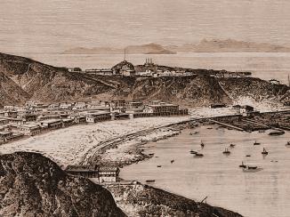
‘SKETCH OF THE PENINSULA OR CAPE OF ADEN’
IOR/X/3251


2 items in this record
Search within this record
The record is made up of 1 plan. It was created in 1846. It was written in English. The original is part of the British Library: Map Collections.
About this record
- Content
Distinctive Features:
Relief shown by contours.
Depth shown by a single line of soundings Measurements of the depth of a body of water. from Long Island to Hedjuf in Western Bay.
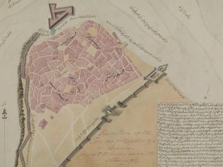
Outline plan of Aden peninsula showing positions of European, Sepoy Term used in English to refer to an Indian infantryman. Carries some derogatory connotations as sometimes used as a means of othering and emphasising race, colour, origins, or rank. and Officers Lines, Ordnance Magazine building, Custom House and Southern Gate. Existing roads coloured in orange. Additions in pencil include four circles with a 1250 yards radius from the Conical Hill on the Munsooree heights, batteries in Ras Tarshayn and Ras Morbut, and Flint Island.
Inscriptions:
On recto The front of a sheet of paper or leaf, often abbreviated to 'r'. , bottom left-hand corner:
‘Copied in the Chief Engrs. Office Bombay 26th September 1846’.
On verso The back of a sheet of paper or leaf, often abbreviated to 'v'. , bottom left-hand corner with bleed-through into the recto The front of a sheet of paper or leaf, often abbreviated to 'r'. :
‘In Bombay Secret Lre. No. 113 of 1846 Recd. via Southampton 10th Novr. 1846 Aden Fortifications’.
- Extent and format
- 1 plan
- Area map covers
- Map loading...
- Scale
- not given
- Scale designator
- Horizontal
- Orientation
- North
- Degree coordinates
- Top-left: 12° 48' 55.4" N, 44° 57' 58.64" E
Top-right: 12° 48' 55.4" N, 45° 3' 35.01" E
Bottom-left: 12° 44' 56.4" N, 44° 57' 58.64" E
Bottom-right: 12° 44' 56.4" N, 45° 3' 35.01" E - Physical characteristics
Materials:
Pen and ink with wash on tracing paper with additions in pencil
Dimensions:
699 x 1040 mm
- Written in
- English in Latin script
- Type
- Map
Archive information for this record
- Original held at
- British Library: Map Collections
- Access conditions
Unrestricted
- Archive reference
- IOR/X/3251
- Former British Library reference
- M.IX.21
- Date(s)
- 1846 (CE, Gregorian)
Access & Reference
History of this record
Related material
Use and share this record
- Share this record
- Cite this record in your research
‘SKETCH OF THE PENINSULA OR CAPE OF ADEN’, British Library: Map Collections, IOR/X/3251, in Qatar Digital Library <https://www.qdl.qa/archive/81055/vdc_100000010760.0x000001> [accessed 22 June 2026]
- Link to this record
https://www.qdl.qa/en/archive/81055/vdc_100000010760.0x000001
- IIIF details
This record has a IIIF manifest available as follows. If you have a compatible viewer you can drag the icon to load it.https://www.qdl.qa/en/iiif/81055/vdc_100000010760.0x000001/manifestOpen in Universal viewerOpen in Mirador viewerMore options for embedding images
Copyright: How to use this content
- Reference
- IOR/X/3251
- Title
- ‘SKETCH OF THE PENINSULA OR CAPE OF ADEN’
- Pages
- 1r:1v
- Author
- Please see item description
- Usage terms
- Public Domain