Five maps from C. Ritter's 'Geography of Arabia' compiled by Carl Zimmermann
IOR/X/2942/5

10 items in this record
Search within this record
The record is made up of 5 map sheets. It was created in 1846. It was written in German. The original is part of the British Library: Map Collections.
About this record
- Content
Imprint:
Berlin, Published by Dietrich Reimer and lithographed A lithograph is an image reproduced from a printing plate whose image areas attract ink and non-image areas repel it. by Hermann Delius.
Distinctive Features:
Original title: 'Fünf Karten zu C. Ritter's Erdkunde von Arabien. Bearbeitet von Carl Zimmermann'.
- Extent and format
- 5 map sheets
- It is grouped into
- 2 imagesRef: IOR/X/2942/5/12 imagesRef: IOR/X/2942/5/22 imagesRef: IOR/X/2942/5/32 imagesRef: IOR/X/2942/5/42 imagesRef: IOR/X/2942/5/5
- Written in
- German in Latin script
- Type
- Map
Archive information for this record
- Original held at
- British Library: Map Collections
- Access conditions
Unrestricted
- Archive reference
- IOR/X/2942/5
- Date(s)
- 1846 (CE, Gregorian)
Access & Reference
History of this record
Related material
Related search terms
- People & organisations
- Karl RitterHermann DeliusDietrich ReimerCarl Zimmermann
Use and share this record
- Share this record
- Cite this record in your research
Five maps from C. Ritter's 'Geography of Arabia' compiled by Carl Zimmermann, British Library: Map Collections, IOR/X/2942/5, in Qatar Digital Library <https://www.qdl.qa/archive/81055/vdc_100000000926.0x0000dd> [accessed 1 April 2025]
- Link to this record
https://www.qdl.qa/en/archive/81055/vdc_100000000926.0x0000dd
- IIIF details
This record has a IIIF manifest available as follows. If you have a compatible viewer you can drag the icon to load it.https://www.qdl.qa/en/iiif/81055/vdc_100000000926.0x0000dd/manifestOpen in Universal viewerOpen in Mirador viewerMore options for embedding images
Copyright: How to use this content
- Reference
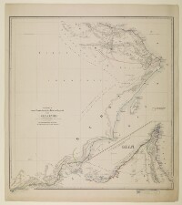
- IOR/X/2942/5/1
- Title
- 'Versuch einer Darstellung der Küsten-Gegend von Oman & Mahra'
- Pages
- 1r:1v
- Author
- Please see item description
- Usage terms
- Public Domain
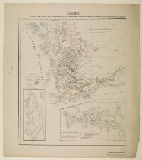
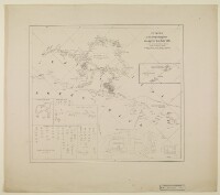
- Reference
- IOR/X/2942/5/2
- Title
- 'Jemen. Versuch einer Darstellung vom glücklichen oder südöstlichen Arabien zu C. Ritters Erdkunde (Drittes Buch West Asien Band VI)'
- Pages
- 2r:2v
- Author
- Please see item description
- Usage terms
- Public Domain
- Reference
- IOR/X/2942/5/3
- Title
- 'Hadramaut. von Carl Zimmermann, Second Lieutenant im 24ten Jnfanterie Regiment, Berlin 1846 bei G. Reimer. (Zum Atlas von Vorder Asien gehörig)'
- Pages
- 3r:3v
- Author
- Please see item description
- Usage terms
- Public Domain
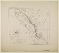
- Reference
- IOR/X/2942/5/4
- Title
- 'Entwurf zu dem Kriegsschauplatze in Asyr vor dem Jahr 1824'
- Pages
- 4r:4v
- Author
- Please see item description
- Usage terms
- Public Domain
- Reference
- IOR/X/2942/5/5
- Title
- ‘Skizze einer Karte von Asyr und einem Theile von Hedjas und Nedjd nach Chedufeaus Materialien, entworfen von den Capt. Ing. Galinier und Ferret’
- Pages
- 5r:5v
- Author
- Please see item description
- Usage terms
- Public Domain