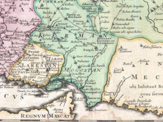
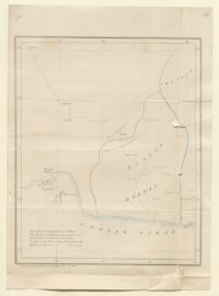
Map showing the boundary of Persia and India
Mss Eur F126/53, f 23
2 items in this record
Search within this record
The record is made up of 1 map. It was created in 1866. It was written in English. The original is part of the British Library: India Office The department of the British Government to which the Government of India reported between 1858 and 1947. The successor to the Court of Directors. Records and Private Papers Documents collected in a private capacity. .
About this record
- Content
Imprint:
Lithographed A lithograph is an image reproduced from a printing plate whose image areas attract ink and non-image areas repel it. in the Superit. Engineer’s Office P.D. April 1866.
Distinctive Features:
Outline map showing in red the traditionally perceived boundary of Persia and India and Lt-Col Goldsmid's amended boundary in blue, his travelled route in relation to these boundaries and also corrected boundaries for the Bampur district.
- Extent and format
- 1 map
- Area map covers
- Map loading...
- Scale
- Scale not given
- Scale designator
- Horizontal
- Orientation
- North
- Degree coordinates
- Top-left: 32° 7' 56.64" N, 54° 0' 51.48" E
Top-right: 32° 7' 56.64" N, 62° 29' 12.84" E
Bottom-left: 24° 59' 54.6" N, 54° 0' 51.48" E
Bottom-right: 24° 59' 54.6" N, 62° 29' 12.84" E - It is part of
- 48 imagesRef: Mss Eur F126/53
- Physical characteristics
Dimensions: 266 x 215 mm, on sheet 352 x 255 mm
- Written in
- English in Latin script
- Type
- Map
Archive information for this record
- Original held at
- British Library: India Office The department of the British Government to which the Government of India reported between 1858 and 1947. The successor to the Court of Directors. Records and Private Papers Documents collected in a private capacity.
- Access conditions
Unrestricted
- Archive reference
- Mss Eur F126/53, f 23
- Date(s)
- 1866 (CE, Gregorian)
Access & Reference
History of this record
Related search terms
- Places
- Persia
Use and share this record
- Share this record
- Cite this record in your research
Map showing the boundary of Persia and India, British Library: India Office Records and Private Papers, Mss Eur F126/53, f 23, in Qatar Digital Library <https://www.qdl.qa/archive/81055/vdc_100024065012.0x000001> [accessed 30 March 2025]
- Link to this record
https://www.qdl.qa/en/archive/81055/vdc_100024065012.0x000001
- IIIF details
This record has a IIIF manifest available as follows. If you have a compatible viewer you can drag the icon to load it.https://www.qdl.qa/en/iiif/81055/vdc_100000001524.0x0003c0/manifestOpen in Universal viewerOpen in Mirador viewerMore options for embedding images
Copyright: How to use this content
- Reference
- Mss Eur F126/53, f 23
- Title
- Map showing the boundary of Persia and India
- Pages
- 23r:23v
- Author
- East India Company, the Board of Control, the India Office, or other British Government Department
- Usage terms
- Open Government Licence