!["مخطط يُظهر الموانئ الرئيسية في الخليج الفارسي إلى جانب البلدات وطرق التجارة التي يخدمها كل واحد منها" [<span dir="ltr">ظ٢٣٩</span>] (٤/٣)](https://iiif.qdl.qa/iiif/images/81055/vdc_100000000112.0x000209/IOR_L_MIL_17_5_3283_0492.jp2/full/!1200,1200/0/default.jpg "\"مخطط يُظهر الموانئ الرئيسية في الخليج الفارسي إلى جانب البلدات وطرق التجارة التي يخدمها كل واحد منها\" [<span dir=\"ltr\">ظ٢٣٩</span>] (٤/٣)")
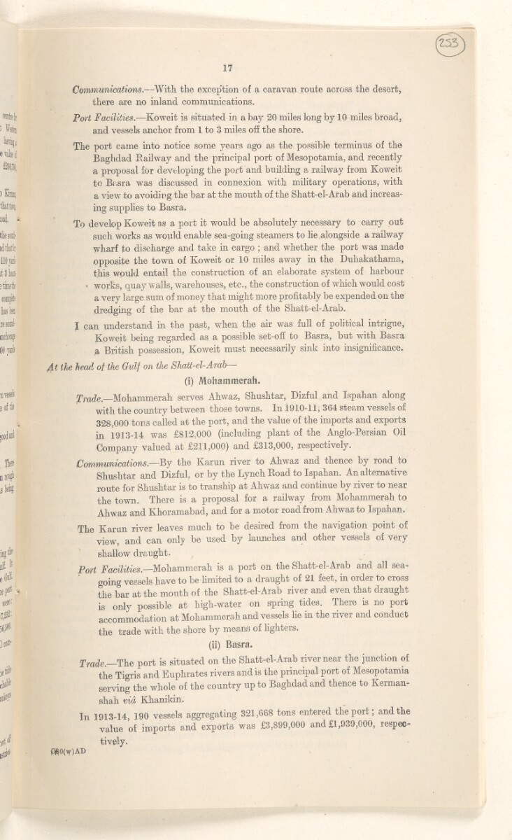
"مخطط يُظهر الموانئ الرئيسية في الخليج الفارسي إلى جانب البلدات وطرق التجارة التي يخدمها كل واحد منها" [ظ٢٣٩] (٤/٣)
محتويات السجل: لوحة خريطة واحدة. يعود تاريخه إلى ٢٠ يونيو ١٩١٧. اللغة أو اللغات المستخدمة: الإنجليزية. النسخة الأصلية محفوظة في المكتبة البريطانية: أوراق خاصة وثائق جُمعت بصفة شخصية. وسجلات من مكتب الهند إدارة الحكومة البريطانية التي كانت الحكومة في الهند ترفع إليها تقاريرها بين عامي ١٨٥٨ و١٩٤٧، حيث خلِفت مجلس إدارة شركة الهند الشرقية. .
نسخ
النسخ مستحدث آليًا ومن المرجّح أن يحتوي على أخطاء.
Communications. —With the exception of a caravan route across the desert,
there are no inland communications.
Port Facilities. —Koweit is situated in a bay 20 miles long by 10 miles broad,
and vessels anchor from 1 to 3 miles off the shore.
The port came into notice some years ago as the possible terminus of the
Baghdad Railway and the principal port of Mesopotamia, and recently
a proposal for developing the port and building a railway from Koweit
to Basra was discussed in connexion with military operations, with
a view to avoiding the bar at the mouth of the Shatt-el-Arab and increas
ing supplies to Basra.
To develop Koweit as a port it would be absolutely necessary to carry out
such works as would enable sea-going steamers to lie alongside a railway
wharf to discharge and take in cargo ; and whether the port was made
opposite the town of Koweit or 10 miles away in the Duhakathama,
this would entail the construction of an elaborate system of harbour
works, quay walls, warehouses, etc., the construction of which would cost
a very large sum of money that might more profitably be expended on the
dredging of the bar at the mouth of the Shatt-el-Arab.
I can understand in the past, when the air was full of political intrigue,
Koweit being regarded as a possible set-off to Basra, but with Basra
a British possession, Koweit must necessarily sink into insignificance.
At the head of the Gidf on the Shatt-el-Arab —
(i) Mohammerah.
Trade. Mohammerah serves Ahwaz, Shushtar, Dizful and Ispahan along
with the country between those towns. In 1910-11, 364 steam vessels of
328,000 tons called at the port, and the value of the imports and exports
in 1913-14 was £812,000 (including plant of the Anglo-Persian Oil
Company valued at £ 211 , 000 ) and £313,000, respectively.
Communications. —By the Karun river to Ahwaz and thence by road to
Shushtar and Dizful, or by the Lynch Road to Ispahan. An alternative
route for Shushtar is to tranship at Ahwaz and continue by river to near
the town. There is a proposal for a railway from Mohammerah to
Ahwaz and Khoramabad, and for a motor road from Ahwaz to Ispahan.
The Karun river leaves much to be desired fiom the navigation point ol
view, and can only be used by launches and other vessels of very
shallow draught.
Port Facilities. —Mohammerah is a port on the Shatt-el-Arab and all sea
going vessels have to be limited to a draught of 21 feet, in order to cross
the bar at the mouth of the Shatt-el-Arab river and even that draught
is only possible at high-water on spring tides. There is no port
accommodation at Mohammerah and vessels lie in the river and conduct
the trade with the shore by means of lighters.
(is) Basra.
Trade. The port is situated on the Shatt-el-Arab river near the junction of
the Tigris and Euphrates rivers and is the principal port of Mesopotamia
serving the whole of the country up to Baghdad and thence to Kerman-
shah via Khanikin.
In 1913-14 190 vessels aggregating 321,668 tons entered the port; and the
value of imports and exports was £3,899,000 and £1,939,000, respec
tively.
$S0(w)AD
حول هذه المادة
- المحتوى
تُظهر الخريطة السكك الحديدية، والحدود السياسية، والبلدات، وأعداد السكان، ونطاقات النفوذ البريطاني والروسي. وهي جزء من تقرير جورج بوكانان عن تنظيم الملاحة في شط العرب في ٢٠ يونيو ١٩١٧.
- الشكل والحيّز
- لوحة خريطة واحدة
- نطاق الخريطة
- Map loading...
- المقياس
- المقياس 1:٣١٦٨٠٠٠
- تحديد المقياس
- أفقي
- اتجاه العرض
- الشمال
- الإحداثيات
- أعلى اليسار: ٤١° ٢٠` ٢,٤`` ش، ٣٧° ٩` ١٩,٠٨`` ق
أعلى اليمين: ٤١° ٢٠` ٢,٤`` ش، ٦٣° ٢٨` ٤٢,٩٦`` ق
أسفل اليسار: ٢٣° ٤٠` ٢٢,٠٨`` ش، ٣٧° ٩` ١٩,٠٨`` ق
أسفل اليمين: ٢٣° ٤٠` ٢٢,٠٨`` ش، ٦٣° ٢٨` ٤٢,٩٦`` ق - الخصائص المادية
المواد: مطبوعة على ورق
الأبعاد: ٧٩٦ x ٧٣٣ مم
- لغة الكتابة
- الإنجليزية بالأحرف اللاتينية للاطّلاع على المعلومات الكاملة لهذا السجل
استخدام وإعادة نشر هذه المادة
- إعادة نشر هذه المادة
"مخطط يُظهر الموانئ الرئيسية في الخليج الفارسي إلى جانب البلدات وطرق التجارة التي يخدمها كل واحد منها" [ظ٢٣٩] (٤/٣)و المكتبة البريطانية: أوراق خاصة وسجلات من مكتب الهندو IOR/L/MIL/17/5/3283, f 239و مكتبة قطر الرقمية <https://www.qdl.qa/archive/81055/vdc_100137829834.0x00005d> [تم الوصول إليها في ٢٦ غشت ٢٠٢٤]
https://www.qdl.qa/العربية/archive/81055/vdc_100137829834.0x00005d
يمكنك نسخ ولصق الفقرة التالية لتضمين الصورة في صفحة الويب الخاصة بك.
<meta charset="utf-8"><a href="https://www.qdl.qa/العربية/archive/81055/vdc_100137829834.0x00005d">"مخطط يُظهر الموانئ الرئيسية في الخليج الفارسي إلى جانب البلدات وطرق التجارة التي يخدمها كل واحد منها" [<span dir="ltr">ظ٢٣٩</span>] (٤/٣)</a> <a href="https://www.qdl.qa/العربية/archive/81055/vdc_100137829834.0x00005d"> <img src="https://iiif.qdl.qa/iiif/images/81055/vdc_100000000112.0x000209/IOR_L_MIL_17_5_3283_0492.jp2/full/!280,240/0/default.jpg" alt="" /> </a>
هذا التسجيل IIIF له ملف ظاهر متوفر كما يلي. إذا كان لديك عارض متوافق للصور يمكنك سحب الأيقونة لتحميله.https://www.qdl.qa/العربية/iiif/81055/vdc_100000000112.0x000209/manifestافتح في المتصفح العامافتح في عارض IIIF ميرادورطرق إضافية لاستخدام صور الأرشيف الرقمي
حقوق النسخ والتأليف: كيفية استخدام هذا المحتوى
- رقم الاستدعاء
- IOR/L/MIL/17/5/3283, f 239
- العنوان
- "مخطط يُظهر الموانئ الرئيسية في الخليج الفارسي إلى جانب البلدات وطرق التجارة التي يخدمها كل واحد منها"
- الصفحات
- ظ٢٣٩ ،ظ٢٣٩:و٢٣٩ ،و٢٣٩
- المؤلف
- شركة الهند الشرقية ولجنة البرلمان البريطاني لشئون الهند ومكتب الهند وإدارات الحكومة البريطانية الأخرى
- شروط الاستخدام
- ترخيص حكومي عام