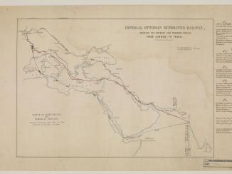
‘Map showing (A) Air Routes, established and projected; (B) Islands in the Persian Gulf; (C) Boundaries of Kuwait and Trucial Area. Map II'
IOR/R/15/1/730, f 88

2 items in this record
Search within this record
The record is made up of 1 map. It was created in 1928. It was written in English. The original is part of the British Library: India Office The department of the British Government to which the Government of India reported between 1858 and 1947. The successor to the Court of Directors. Records and Private Papers Documents collected in a private capacity. .
About this record
- Content
Imprint:
Printed at the War Office, October 1928. Geographical Section. General Staff. No. 3869.
Distinctive Features:
Relief shown by gradient tints and spot heights.
Classified "Secret".
Shows various air routes with established aerodromes, proposed refuelling and emergency stations. International boundaries coloured with a table of reference and an explanatory note provided at the lower right of map.
Coastline and islands outlined in pencil.
- Extent and format
- 1 map
- Area map covers
- Map loading...
- Scale
- Scale approximately 1:4,000,000
- Scale designator
- Horizontal
- Orientation
- North
- Degree coordinates
- Top-left: 32° 2' 40.2" N, 43° 55' 9.12" E
Top-right: 32° 2' 40.2" N, 70° 2' 16.44" E
Bottom-left: 20° 2' 31.56" N, 43° 55' 9.12" E
Bottom-right: 20° 2' 31.56" N, 70° 2' 16.44" E - It is part of
- 188 imagesRef: IOR/R/15/1/730
- Physical characteristics
Dimensions:
331 x 700 mm, on sheet 417 x 763 mm
- Written in
- English in Latin script
- Type
- Map
Archive information for this record
- Original held at
- British Library: India Office The department of the British Government to which the Government of India reported between 1858 and 1947. The successor to the Court of Directors. Records and Private Papers Documents collected in a private capacity.
- Access conditions
Unrestricted
- Archive reference
- IOR/R/15/1/730, f 88
- Date(s)
- 1928 (CE, Gregorian)
Access & Reference
History of this record
Related search terms
- Places
- Persian Gulf
Use and share this record
- Share this record
- Cite this record in your research
‘Map showing (A) Air Routes, established and projected; (B) Islands in the Persian Gulf; (C) Boundaries of Kuwait and Trucial Area. Map II', British Library: India Office Records and Private Papers, IOR/R/15/1/730, f 88, in Qatar Digital Library <https://www.qdl.qa/archive/81055/vdc_100023133704.0x000002> [accessed 14 March 2025]
- Link to this record
https://www.qdl.qa/en/archive/81055/vdc_100023133704.0x000002
- IIIF details
This record has a IIIF manifest available as follows. If you have a compatible viewer you can drag the icon to load it.https://www.qdl.qa/en/iiif/81055/vdc_100000000193.0x0002c0/manifestOpen in Universal viewerOpen in Mirador viewerMore options for embedding images
Copyright: How to use this content
- Reference
- IOR/R/15/1/730, f 88
- Title
- ‘Map showing (A) Air Routes, established and projected; (B) Islands in the Persian Gulf; (C) Boundaries of Kuwait and Trucial Area. Map II'
- Pages
- 88r:88v
- Author
- East India Company, the Board of Control, the India Office, or other British Government Department
- Usage terms
- Open Government Licence