Explore Qatar Digital Library
- Items in the archive (2,456,573)
- Articles from our experts (239)
- Search tips Tips and syntax for searching
Showing records 21 to 30
-

‘Persian Gulf – Duria Dowlut – Bugla – Piracy of – Further proceedings of Government in obtaining compensation for the losses sustained on that occasion Vol. 2’
This item consists of copies of correspondence, consultations, memoranda, resolutions, and minutes cited in, or enclosed with, political letters from the ...
264 images in record Ref: IOR/F/4/1767/72462 Date(s): 13 Jul 1835-11 Apr 1838
![]()
![]()
![]()
![]()
![]()
![]()
![]()
![]()
![]()
![]()
![]()
![]()
![]()
![]()
![]()
![]()
![]()
![]()
![]()
![]()
![]()
![]()
![]()
![]()
![]()
![]()
![]()
![]()
![]()
![]()
-

'Relative to the expense and establishment of the Persian Mission.'
The item consists of correspondence regarding the expenses of the East India Company’s Persian Mission. The bulk of the correspondence dates from the ...
108 images in record Ref: IOR/F/4/1137/30251 Date(s): 30 Jul 1823-21 Jul 1829
![]()
![]()
![]()
![]()
![]()
![]()
![]()
![]()
![]()
![]()
![]()
![]()
![]()
![]()
![]()
![]()
![]()
![]()
![]()
![]()
![]()
![]()
![]()
![]()
![]()
![]()
![]()
![]()
![]()
![]()
-
File 57/1928 Pt 6 'Iraq-Nejd Relations: Koweit Situation. Air and Car Reconnaisances.'
The volume concerns the defence of the frontier of Koweit [Kuwait] against raids by Akhwan [Ikhwan] tribesmen (also referred to as 'Wahabis') from the ...
1,126 images in record Ref: IOR/L/PS/10/1238 Date(s): 13 Dec 1927-18 May 1929
![]()
![]()
![]()
![]()
![]()
![]()
![]()
![]()
![]()
![]()
![]()
![]()
![]()
![]()
![]()
![]()
![]()
![]()
![]()
![]()
![]()
![]()
![]()
![]()
![]()
![]()
![]()
![]()
![]()
![]()
-
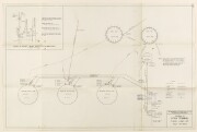
'THE BAHREIN PETROLEUM COMPANY CO. LTD. PRODUCING DEPARTMENT - SITRA TERMINAL TANK LINK-UP'
This technical diagram illustrates the correct connections between tanks at the Sitra Terminal giving information on gates, size of crude oil tanks, drains ...
2 images in record Ref: IOR/L/PS/10/1004 f 38 Date(s): 1935
![]()
![]()
-
File 2794/1921 Pt 16 'Persian Gulf: Oil Bahrain. Calibration of Tanks and measurement of oil.'
The file comprises telegrams, despatches, correspondence, memoranda, and notes relating to the calibration and measurement of the oil storage tanks of ...
358 images in record Ref: IOR/L/PS/10/1004 Date(s): 1934-1942
![]()
![]()
![]()
![]()
![]()
![]()
![]()
![]()
![]()
![]()
![]()
![]()
![]()
![]()
![]()
![]()
![]()
![]()
![]()
![]()
![]()
![]()
![]()
![]()
![]()
![]()
![]()
![]()
![]()
![]()
-
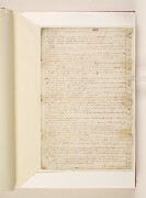
‘Steward’s Account of Disbursements for the Month of February 1721’
Steward's account of expenditure for the month of February 1721 [New Style date February 1722], signed by Francis Dickinson and dated Mocha, 1 March 1721. ...
2 images in record Ref: IOR/G/17/1 Part 1 f.43 Date(s): 1 Mar 1722
![]()
![]()
-

Letter from the Supervisor to Mr Edward Say
Letter to Mr Edward Say containing the Supervisor's enquiries about the discharge of Mr John Hill. The letter was delivered in Council, 26 June 1721, and ...
4 images in record Ref: IOR/G/17/1 Part 1 f.44-45 Date(s): 19 Mar 1722
![]()
![]()
![]()
![]()
-

‘Acco:t Loss of weight of two Chests Treasures of Ship Sunderland’
Account certifying that two chests from the ship Sunderland were found short of weight. It is dated Mocha, 30 June 1721, and signed by Henry Albert, Warehouse ...
2 images in record Ref: IOR/G/17/1 Part 1 f.46 Date(s): 22 Apr 1722
![]()
![]()
-

‘Stewards Acco’ of Disbursements for ye month of June 1721’
Steward's account of expenditure for the month of June 1721. It was drawn up by Thomas Rammell and is dated 30 June 1721. It lists the amount spent on ...
4 images in record Ref: IOR/G/17/1 Part 1 ff.47-48 Date(s): 19 Mar 1722
![]()
![]()
![]()
![]()
-

‘Factory Charges for the Month of June 1721’
Account of Factory charges and general charges in Spanish dollars for the month of June 1721. It was drawn up by Thomas Rammell and is dated 30 June 1721. ...
2 images in record Ref: IOR/G/17/1 Part 1 f.49 Date(s): 19 Mar 1722
![]()
![]()


