!['Military Report on the Arabian Shores of the Persian Gulf, Kuwait, Bahrein, Hasa, Qatar, Trucial Oman and Oman' [‎169] (183/226)](https://iiif.qdl.qa/iiif/images/81055/vdc_100000000239.0x0001d1/IOR_L_MIL_17_15_141_0184.jp2/full/!1200,1200/0/default.jpg "'Military Report on the Arabian Shores of the Persian Gulf, Kuwait, Bahrein, Hasa, Qatar, Trucial Oman and Oman' [‎169] (183/226)")
'Military Report on the Arabian Shores of the Persian Gulf, Kuwait, Bahrein, Hasa, Qatar, Trucial Oman and Oman' [169] (183/226)
The record is made up of 1 volume (112 folios). It was created in 1933. It was written in English. The original is part of the British Library: India Office The department of the British Government to which the Government of India reported between 1858 and 1947. The successor to the Court of Directors. Records and Private Papers Documents collected in a private capacity. .
Transcription
This transcription is created automatically. It may contain errors.
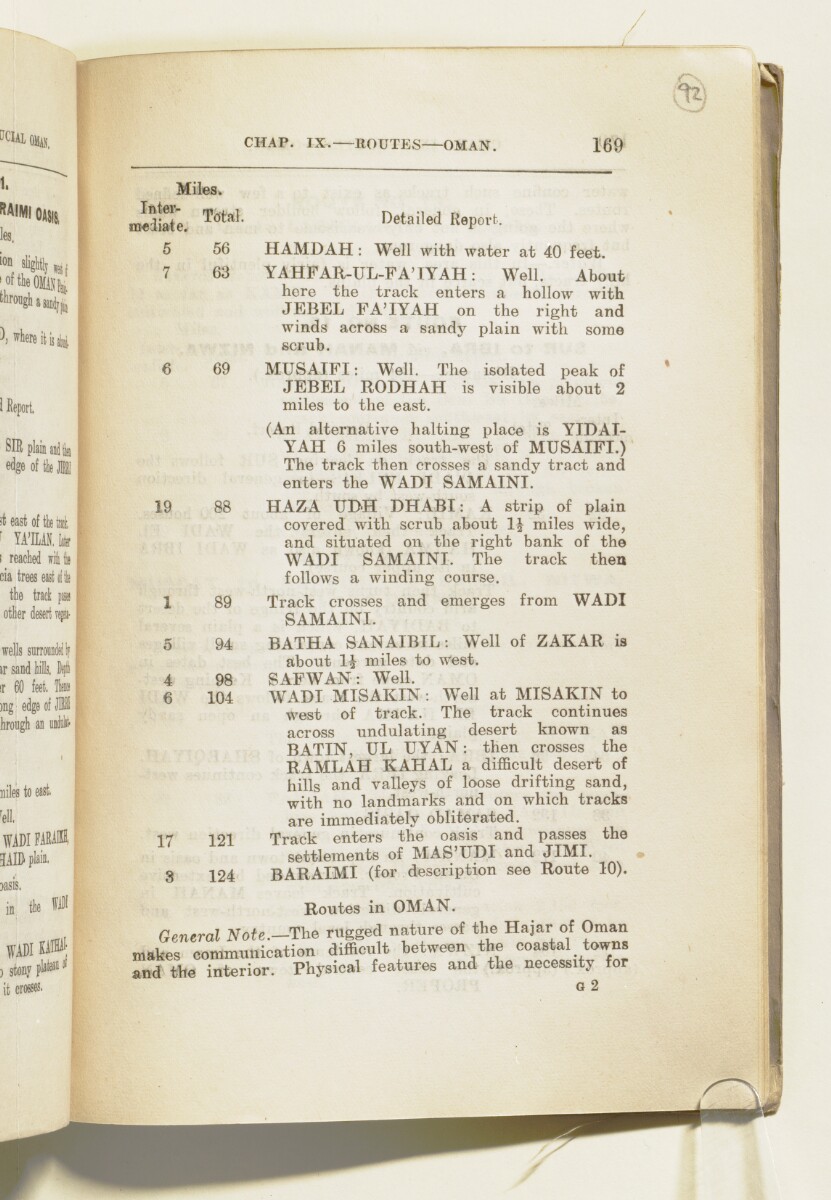
CHAP. IX. ROUTES OMAN.
169
Miles.
mciiate, TcftaL Detailed Report.
5 56 H AMD AH : Well with Avater at 40 feet.
7 63 YAHFAR-UL-FA'IYAH: Well. About
here the track enters a hollow with
JEBEL FA'IYAH on the right and
winds across a sandy plain with some
scrub.
6 69 MUSAIFI: Well. The isolated peak of
JEBEL RODHAH is visible about 2
miles to the east.
(An alternative halting place is YIDAI-
YAH 6 miles south-west of MUSAIFI.)
The track then crosses a sandy tract and
enters the
WADI
A seasonal or intermittent watercourse, or the valley in which it flows.
SAMAINI.
19 88 HAZA TJDH DHABI: A strip of plain
covered with scrub about miles wide,
and situated on the right bank of the
WADI
A seasonal or intermittent watercourse, or the valley in which it flows.
SAMAINI. The track then
follows a winding course.
1 89 Track crosses and emerges from
WADI
A seasonal or intermittent watercourse, or the valley in which it flows.
SAMAINI.
5 94 BATHA SANAIBIL; Well of ZAKAR is
about li miles to west.
4 98 SAFWAN: Well.
6 104
WADI
A seasonal or intermittent watercourse, or the valley in which it flows.
MISAKIN : Well at MISAKIN to
west of track. The track continues
across undulating desert known as
BATIN, UL UYAN: then crosses the
RAMLAH KAHAL a difficult desert of
hills and valleys of loose drifting sand,
with no landmarks and on which tracks
are immediately obliterated.
-17 ioI Track enters the oasis and passes the
settlements of MAS'UDI and JIMI.
8 124 BARAIMI (for description see Route 10).
Routes in OMAN.
General Note.—The rugged nature of the Hajar of Oman
makes communication difficult between the coastal towns
and the interior. Physical features and the necessity for
G 2
About this item
- Content
The volume is Military Report on the Arabian Shores of the Persian Gulf The historical term used to describe the body of water between the Arabian Peninsula and Iran. , Kuwait, Bahrein, Hasa, Qatar, Trucial Oman A name used by Britain from the nineteenth century to 1971 to refer to the present-day United Arab Emirates. and Oman (Calcutta: Government of India Press, 1933). The volume was produced by the General Staff, India. The place name Bahrain is rendered in the title and elsewhere in the volume in the spelling 'Bahrein'.
The volume contains information in separate sections for each of the places listed in the title under the following chapter headings:
- I Historical (ff 8-14);
- II Geography, Climate, Health (ff 15-54);
- III Population (ff 54-67);
- IV Water Supply; Resources (ff 68-70);
- V Armed Forces (ff 70-75);
- VI Aviation (ff 75-78);
- VII Political (ff 79-81);
- VIII Inter-Communication [wireless and telegraph] (ff 81-82);
- IX Communications [land routes] (ff 83-98).
There are three appendices, which follow the same format:
- I Currency, Weights and Measures (f 99-102);
- II Landing Facilities - Maritime (ff 103-106);
- III List of Maps (f 106).
The volume includes five maps of the region (ff 109-113).
- Extent and format
- 1 volume (112 folios)
- Arrangement
There is a list of contents on ff 6-7, which contains an inaccuracy in the title and number of the last chapter.
- Physical characteristics
Foliation: the foliation sequence commences at 1 on the front cover and terminates at 113 on the last of the five maps inserted in a pocket attached to the back cover. The numbers are written in pencil, are circled, and appear in the top right hand corner of the recto The front of a sheet of paper or leaf, often abbreviated to 'r'. page of each folio. All five maps (ff 109, 110, 111, 112, 113) need to folded out to be examined. This is the system used to determine the sequence of pages in the volume.
Pagination: an original printed pagination sequence, numbered 2-198 appears between ff 8-106.
- Written in
- English in Latin script View the complete information for this record
Use and share this item
- Share this item
'Military Report on the Arabian Shores of the Persian Gulf, Kuwait, Bahrein, Hasa, Qatar, Trucial Oman and Oman' [169] (183/226), British Library: India Office Records and Private Papers, IOR/L/MIL/17/15/141, in Qatar Digital Library <https://www.qdl.qa/archive/81055/vdc_100023509623.0x0000b9> [accessed 5 April 2025]
https://www.qdl.qa/en/archive/81055/vdc_100023509623.0x0000b9
Copy and paste the code below into your web page where you would like to embed the image.
<meta charset="utf-8"><a href="https://www.qdl.qa/en/archive/81055/vdc_100023509623.0x0000b9">'Military Report on the Arabian Shores of the Persian Gulf, Kuwait, Bahrein, Hasa, Qatar, Trucial Oman and Oman' [‎169] (183/226)</a> <a href="https://www.qdl.qa/en/archive/81055/vdc_100023509623.0x0000b9"> <img src="https://iiif.qdl.qa/iiif/images/81055/vdc_100000000239.0x0001d1/IOR_L_MIL_17_15_141_0184.jp2/full/!280,240/0/default.jpg" alt="" /> </a>
This record has a IIIF manifest available as follows. If you have a compatible viewer you can drag the icon to load it.https://www.qdl.qa/en/iiif/81055/vdc_100000000239.0x0001d1/manifestOpen in Universal viewerOpen in Mirador viewerMore options for embedding images
Copyright: How to use this content
- Reference
- IOR/L/MIL/17/15/141
- Title
- 'Military Report on the Arabian Shores of the Persian Gulf, Kuwait, Bahrein, Hasa, Qatar, Trucial Oman and Oman'
- Pages
- front, front-i, i-r:iii-r, ii-v, iv-r:iv-v, 1:4, 1:208, v-r:v-v, back-i, back
- Author
- East India Company, the Board of Control, the India Office, or other British Government Department
- Usage terms
- Open Government Licence